No Photo
Property Record
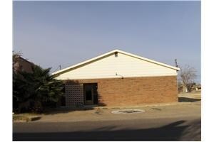
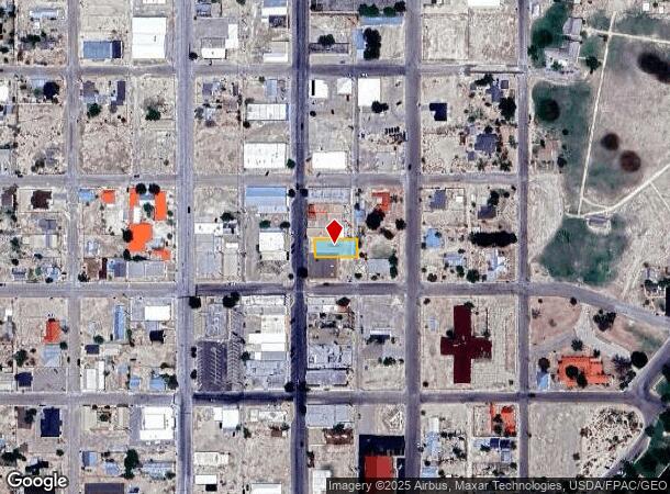
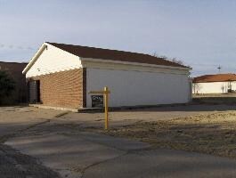
206 S Main St, Fort Stockton, TX 79735
NEARBY LISTINGS FOR SALE OR LEASE
-
-
View all Fort Stockton listings for sale on LoopNet.com
Property Detail
206 S Main St
Other Market Areas
Old Fort
01540-02200-12000-000000
11 22 OLD FORT EXC N1F -E57F- & ALL 12-15
Taxexempt
Pecos
2025
Texas
2025
0.37 AC
950300
Texas West Area
6,375 SF
DEMOGRAPHICS near 206 S Main St
1 Mile
3 Mile
5 Mile
2024 Total Population
5,025
10,431
11,621
2029 Population
4,906
10,117
11,244
Pop Growth 2024-2029
(2.37%)
(3.01%)
(3.24%)
Average Age
37
38
38
2024 Total Households
1,867
3,574
4,004
HH Growth 2024-2029
(2.52%)
(3.39%)
(3.60%)
Median Household Inc
$38,749
$53,463
$52,946
Avg Household Size
2.70
2.70
2.70
2024 Avg HH Vehicles
2.00
2.00
2.00
Median Home Value
$111,927
$127,578
$121,780
Median Year Built
1972
1975
1976
Nearby Places
Map Layers
Map Styles
 Street
 Aerial
- Restaurants
- Banks
- Shops
- Fitness
- Groceries
Nearby Properties
Address
Land Use
TOTAL SIZE
Lot Size
Zoning
Address
Land Use
TOTAL SIZE
Lot Size
Zoning
85,314 SF
2.25 AC
Address
Land Use
TOTAL SIZE
Lot Size
Zoning
236,285 SF
17.26 AC
Address
Land Use
TOTAL SIZE
Lot Size
Zoning
161,954 SF
3.60 AC
Address
Land Use
TOTAL SIZE
Lot Size
Zoning
Address
Land Use
TOTAL SIZE
Lot Size
Zoning
124,199 SF
3.60 AC
Address
Land Use
TOTAL SIZE
Lot Size
Zoning
42,528 SF
2.52 AC
Address
Land Use
TOTAL SIZE
Lot Size
Zoning
29,338 SF
0.89 AC
Address
Land Use
TOTAL SIZE
Lot Size
Zoning
50,347 SF
2.07 AC
Address
Land Use
TOTAL SIZE
Lot Size
Zoning
71,300 SF
1.40 AC
Address
Land Use
TOTAL SIZE
Lot Size
Zoning
429,583 SF
8.99 AC
Address
Land Use
TOTAL SIZE
Lot Size
Zoning
109,883 SF
60.58 AC
Address
Land Use
TOTAL SIZE
Lot Size
Zoning
196,521 SF
6.55 AC
Address
Land Use
TOTAL SIZE
Lot Size
Zoning
71,784 SF
2.11 AC
Address
Land Use
TOTAL SIZE
Lot Size
Zoning
227,405 SF
4.67 AC
Address
Land Use
TOTAL SIZE
Lot Size
Zoning
13,774 SF
9.94 AC
Address
Land Use
TOTAL SIZE
Lot Size
Zoning
109,017 SF
1.47 AC
Address
Land Use
TOTAL SIZE
Lot Size
Zoning
276,502 SF
8.30 AC
Address
Land Use
TOTAL SIZE
Lot Size
Zoning
71,905 SF
2.31 AC
Address
Land Use
TOTAL SIZE
Lot Size
Zoning
11,257 SF
2.10 AC
Address
Land Use
TOTAL SIZE
Lot Size
Zoning
42,625 SF
2.07 AC
Address
Land Use
TOTAL SIZE
Lot Size
Zoning
153,293 SF
10.42 AC
Address
Land Use
TOTAL SIZE
Lot Size
Zoning
277,032 SF
10.91 AC
Address
Land Use
TOTAL SIZE
Lot Size
Zoning
58,971 SF
28.96 AC
Address
Land Use
TOTAL SIZE
Lot Size
Zoning
87,532 SF
2.07 AC
Address
Land Use
TOTAL SIZE
Lot Size
Zoning
68,900 SF
3.89 AC
Address
Land Use
TOTAL SIZE
Lot Size
Zoning
255,380 SF
7 AC
Address
Land Use
TOTAL SIZE
Lot Size
Zoning
42,500 SF
1.77 AC
Address
Land Use
TOTAL SIZE
Lot Size
Zoning
42,933 SF
2.25 AC
Address
Land Use
TOTAL SIZE
Lot Size
Zoning
46,315 SF
0.01 AC
Address
Land Use
TOTAL SIZE
Lot Size
Zoning
14,434 SF
0.44 AC
The World's #1 Commercial Real Estate Marketplace
Connect with us
© 2025 CoStar Group
The information above has been obtained from sources believed reliable. While we do not doubt its accuracy we have not verified it and make no guarantee, warranty or representation about it. It is your responsibility to independently confirm its accuracy and completeness. Any projections, opinions, assumptions, or estimates used are for example only and do not represent the current or future performance of the property. The value of this transaction to you depends on tax and other factors which should be evaluated by your tax, financial, and legal advisors. You and your advisors should conduct a careful, independent investigation of the property to determine to your satisfaction the suitability of the property for your needs.