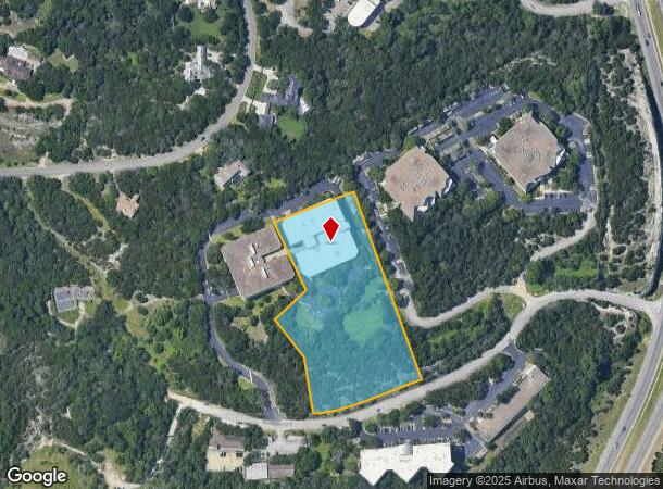
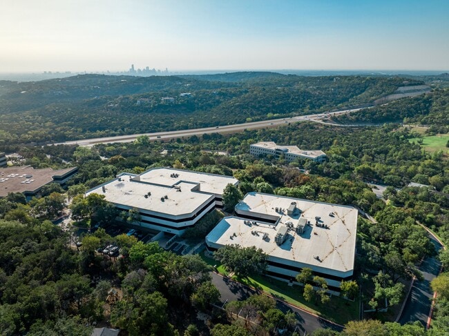
Property Record
134 Wild Basin Rd, Austin, TX 78746

This Property Is For Sale
Current Lease Availabilities
NEARBY LISTINGS FOR SALE OR LEASE
Property Detail
134 Wild Basin Rd
Austin-Round Rock-San Marcos, TX
Monte Verde Subd
120046
LOT 2 MONTE VERDE SUBD
Officebuilding
Travis
X
Texas
48453C0440J
2
2024
3.99 AC
2025
Southwest
001918
Austin
102,971 SF
DEMOGRAPHICS near 134 Wild Basin Rd
1 Mile
3 Mile
5 Mile
2024 Total Population
1,538
25,439
108,760
2029 Population
1,656
27,433
117,290
Pop Growth 2024-2029
+ 7.67%
+ 7.84%
+ 7.84%
Average Age
43
43
41
2024 Total Households
552
9,275
46,069
HH Growth 2024-2029
+ 8.33%
+ 8.68%
+ 8.64%
Median Household Inc
$189,166
$205,943
$139,937
Avg Household Size
2.70
2.70
2.30
2024 Avg HH Vehicles
2.00
2.00
2.00
Median Home Value
$1,063,818
$1,044,083
$936,830
Median Year Built
1989
1990
1989
Nearby Places
Map Layers
Map Styles
 Street
 Aerial
- Restaurants
- Banks
- Shops
- Fitness
- Groceries
PUBLIC TRANSPORTATION
COMMUTER RAIL
Highland Station (Capital MetroRail - Capital Metropolitan Transportation Authority Rail (MetroRail))
DRIVE
WALK
Distance
Highland Station (Capital MetroRail - Capital Metropolitan Transportation Authority Rail (MetroRail))
17 min
9.7 mi
AIRPORT
Austin-Bergstrom International
DRIVE
WALK
Distance
Austin-Bergstrom International
20 min
16.1 mi
Nearby Properties
Address
Land Use
TOTAL SIZE
Lot Size
Zoning
Address
Land Use
TOTAL SIZE
Lot Size
Zoning
632.50 AC
Address
Land Use
TOTAL SIZE
Lot Size
Zoning
599,648 SF
16.83 AC
Address
Land Use
TOTAL SIZE
Lot Size
Zoning
133,092 SF
54.32 AC
Address
Land Use
TOTAL SIZE
Lot Size
Zoning
377,128 SF
14.99 AC
Address
Land Use
TOTAL SIZE
Lot Size
Zoning
221,273 SF
48.10 AC
Address
Land Use
TOTAL SIZE
Lot Size
Zoning
217,490 SF
19.03 AC
Address
Land Use
TOTAL SIZE
Lot Size
Zoning
344,392 SF
24.53 AC
Address
Land Use
TOTAL SIZE
Lot Size
Zoning
71,812 SF
9.18 AC
Address
Land Use
TOTAL SIZE
Lot Size
Zoning
349,535 SF
245.89 AC
Address
Land Use
TOTAL SIZE
Lot Size
Zoning
560,549 SF
8.07 AC
Address
Land Use
TOTAL SIZE
Lot Size
Zoning
210,000 SF
12.74 AC
Address
Land Use
TOTAL SIZE
Lot Size
Zoning
250,000 SF
9.22 AC
Address
Land Use
TOTAL SIZE
Lot Size
Zoning
149,610 SF
12.67 AC
Address
Land Use
TOTAL SIZE
Lot Size
Zoning
12.17 AC
Address
Land Use
TOTAL SIZE
Lot Size
Zoning
135,103 SF
20.58 AC
Address
Land Use
TOTAL SIZE
Lot Size
Zoning
170,058 SF
28.28 AC
Address
Land Use
TOTAL SIZE
Lot Size
Zoning
202,346 SF
16.50 AC
Address
Land Use
TOTAL SIZE
Lot Size
Zoning
153,404 SF
13.60 AC
Address
Land Use
TOTAL SIZE
Lot Size
Zoning
130,476 SF
13.60 AC
Address
Land Use
TOTAL SIZE
Lot Size
Zoning
149,352 SF
20.99 AC
Address
Land Use
TOTAL SIZE
Lot Size
Zoning
161,450 SF
19.03 AC
Address
Land Use
TOTAL SIZE
Lot Size
Zoning
83,110 SF
32 AC
Address
Land Use
TOTAL SIZE
Lot Size
Zoning
156,682 SF
3.45 AC
Address
Land Use
TOTAL SIZE
Lot Size
Zoning
110,911 SF
13.37 AC
Address
Land Use
TOTAL SIZE
Lot Size
Zoning
112,455 SF
21.04 AC
Address
Land Use
TOTAL SIZE
Lot Size
Zoning
164,188 SF
6.36 AC
Address
Land Use
TOTAL SIZE
Lot Size
Zoning
294,733 SF
14.62 AC
Address
Land Use
TOTAL SIZE
Lot Size
Zoning
142,000 SF
7.82 AC
Address
Land Use
TOTAL SIZE
Lot Size
Zoning
156,682 SF
3.15 AC
Address
Land Use
TOTAL SIZE
Lot Size
Zoning
141,927 SF
21.20 AC
The World's #1 Commercial Real Estate Marketplace
Connect with us
© 2026 CoStar Group
The information above has been obtained from sources believed reliable. While we do not doubt its accuracy we have not verified it and make no guarantee, warranty or representation about it. It is your responsibility to independently confirm its accuracy and completeness. Any projections, opinions, assumptions, or estimates used are for example only and do not represent the current or future performance of the property. The value of this transaction to you depends on tax and other factors which should be evaluated by your tax, financial, and legal advisors. You and your advisors should conduct a careful, independent investigation of the property to determine to your satisfaction the suitability of the property for your needs.