Property Record
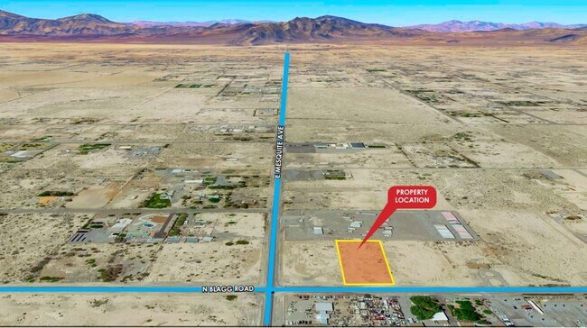
2060 N Blagg Rd, Pahrump, NV 89060


Property Detail
2060 N Blagg Rd
Pahrump, NV
T19S R53E S33 F#460446 P.3 1.17AC MESQUITE RANCH ESTATES
29-182-11
NYE
Commercialacreage
Nevada
NC
20
C and X Area of minimal flood hazard, usually depicted on FIRMs as above the 500-year flood level.
1.17 AC
2024
Carson City/Nevada Area
2025
Other Market Areas
960413
NEARBY LISTINGS FOR SALE OR LEASE
-
-
-
-
-
-
No Photo
-
-
View all Pahrump listings for sale on LoopNet.com
DEMOGRAPHICS near 2060 N Blagg Rd
1 mile
3 mile
5 mile
2025 Total Population
1,184
10,498
25,837
2030 Population
1,276
11,093
27,395
Pop Growth 2025-2030
+ 7.77%
+ 5.67%
+ 6.03%
Average Age
49
50
49
2025 Total Households
449
4,293
11,009
HH Growth 2025-2030
+ 8.46%
+ 5.94%
+ 6.11%
Median Household Inc
$65,000
$53,179
$53,986
Avg Household Size
2.30
2.20
2.30
2025 Avg HH Vehicles
2.00
2.00
2.00
Median Home Value
$256,372
$246,871
$266,865
Median Year Built
1995
1996
1996
Nearby Places
Map Layers
Map Styles
 Street
 Aerial
Layers
 Traffic
 Biking
Places
Listings with unknown addresses are not visible on the map
- Restaurants
- Banks
- Shops
- Fitness
- Groceries
SALE & LEASE HISTORY
LISTING DATE
SALE/LEASE

Nov 03, 2021
For Sale
Aug 04, 2022
For Sale
Nearby Properties
Address
Land Use
TOTAL SIZE
Lot Size
Zoning
Address
Land Use
TOTAL SIZE
Lot Size
Zoning
191,653 SF
118.11 AC
CF
Address
Land Use
TOTAL SIZE
Lot Size
Zoning
76,885 SF
12.53 AC
LI
Address
Land Use
TOTAL SIZE
Lot Size
Zoning
128,429 SF
19.39 AC
CF
Address
Land Use
TOTAL SIZE
Lot Size
Zoning
51,128 SF
24.15 AC
M
Address
Land Use
TOTAL SIZE
Lot Size
Zoning
156,375 SF
13.60 AC
GC
Address
Land Use
TOTAL SIZE
Lot Size
Zoning
106,309 SF
12.24 AC
GC
Address
Land Use
TOTAL SIZE
Lot Size
Zoning
57,418 SF
18.28 AC
CF
Address
Land Use
TOTAL SIZE
Lot Size
Zoning
62,279 SF
7.09 AC
GC
Address
Land Use
TOTAL SIZE
Lot Size
Zoning
6.91 AC
LI
Address
Land Use
TOTAL SIZE
Lot Size
Zoning
12,000 SF
9.54 AC
CF
Address
Land Use
TOTAL SIZE
Lot Size
Zoning
48,436 SF
5 AC
M
Address
Land Use
TOTAL SIZE
Lot Size
Zoning
560 SF
5.30 AC
LI
Address
Land Use
TOTAL SIZE
Lot Size
Zoning
10,282 SF
34.27 AC
OS
Address
Land Use
TOTAL SIZE
Lot Size
Zoning
13,885 SF
2.01 AC
M
Address
Land Use
TOTAL SIZE
Lot Size
Zoning
18,746 SF
5.08 AC
NC
Address
Land Use
TOTAL SIZE
Lot Size
Zoning
12,160 SF
1.26 AC
M
Address
Land Use
TOTAL SIZE
Lot Size
Zoning
12,000 SF
5 AC
CM
Address
Land Use
TOTAL SIZE
Lot Size
Zoning
7,656 SF
5.75 AC
CF
Address
Land Use
TOTAL SIZE
Lot Size
Zoning
40,514 SF
142.77 AC
Address
Land Use
TOTAL SIZE
Lot Size
Zoning
24,400 SF
1.10 AC
GC
Address
Land Use
TOTAL SIZE
Lot Size
Zoning
8,400 SF
2.17 AC
GC
Address
Land Use
TOTAL SIZE
Lot Size
Zoning
9,306 SF
4.69 AC
MU
Address
Land Use
TOTAL SIZE
Lot Size
Zoning
20,575 SF
1.63 AC
GC
Address
Land Use
TOTAL SIZE
Lot Size
Zoning
17,070 SF
2.11 AC
GC
Address
Land Use
TOTAL SIZE
Lot Size
Zoning
4,931 SF
1.21 AC
GC
Address
Land Use
TOTAL SIZE
Lot Size
Zoning
0.46 AC
AO
Address
Land Use
TOTAL SIZE
Lot Size
Zoning
11,368 SF
4.71 AC
HI
Address
Land Use
TOTAL SIZE
Lot Size
Zoning
20,000 SF
4.60 AC
LI
Address
Land Use
TOTAL SIZE
Lot Size
Zoning
19,543 SF
1.47 AC
GC
Address
Land Use
TOTAL SIZE
Lot Size
Zoning
11,813 SF
1.30 AC
GC
The World's #1 Commercial Real Estate Marketplace
Connect with us
© 2026 CoStar Group
The information above has been obtained from sources believed reliable. While we do not doubt its accuracy we have not verified it and make no guarantee, warranty or representation about it. It is your responsibility to independently confirm its accuracy and completeness. Any projections, opinions, assumptions, or estimates used are for example only and do not represent the current or future performance of the property. The value of this transaction to you depends on tax and other factors which should be evaluated by your tax, financial, and legal advisors. You and your advisors should conduct a careful, independent investigation of the property to determine to your satisfaction the suitability of the property for your needs.