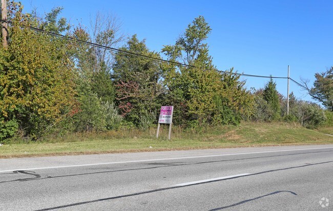
Property Record
2060 State Route 125, Batavia, OH 45103
NEARBY LISTINGS FOR SALE OR LEASE
Property Detail
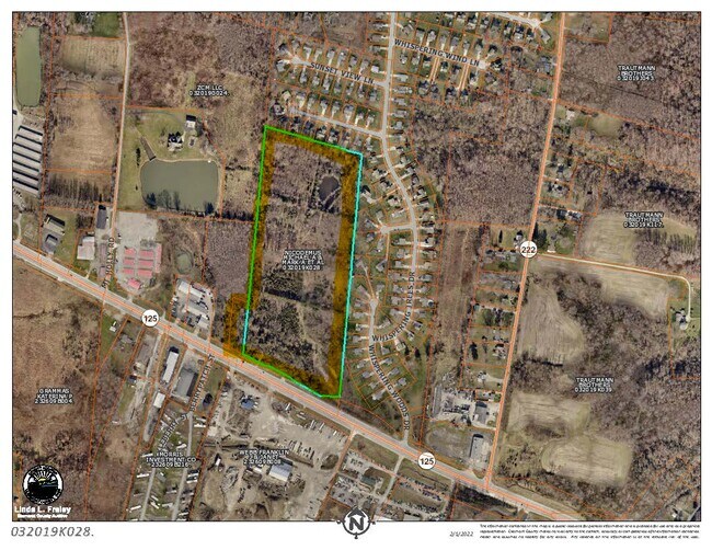
2060 State Route 125
Cincinnati, OH-KY-IN
Jones M S No 934
03-20-19K-028
06TY .175 TO 282.
Agriculturalland
Clermont
X
Ohio
39025C0245G
21.39 AC
2024
Eastgate/Anderson Twp
2024
Cincinnati/Dayton
041001
DEMOGRAPHICS near 2060 State Route 125
1 Mile
3 Mile
5 Mile
2024 Total Population
2,374
16,743
44,770
2029 Population
2,455
17,394
46,186
Pop Growth 2024-2029
+ 3.41%
+ 3.89%
+ 3.16%
Average Age
40
38
39
2024 Total Households
876
6,338
16,940
HH Growth 2024-2029
+ 3.54%
+ 3.90%
+ 3.22%
Median Household Inc
$55,144
$60,227
$66,170
Avg Household Size
2.60
2.60
2.60
2024 Avg HH Vehicles
2.00
2.00
2.00
Median Home Value
$166,455
$182,816
$207,141
Median Year Built
1990
1994
1990
Nearby Places
Map Layers
Map Styles
 Street
 Aerial
- Restaurants
- Banks
- Shops
- Fitness
- Groceries
PUBLIC TRANSPORTATION
AIRPORT
Cincinnati/Northern Kentucky International
DRIVE
WALK
Distance
Cincinnati/Northern Kentucky International
47 min
31.8 mi
SALE & LEASE HISTORY
LISTING DATE
SALE/LEASE

Mar 08, 2022
For Sale
Nearby Properties
Address
Land Use
TOTAL SIZE
Lot Size
Zoning
Address
Land Use
TOTAL SIZE
Lot Size
Zoning
16.02 AC
Address
Land Use
TOTAL SIZE
Lot Size
Zoning
1,380 SF
8.78 AC
Address
Land Use
TOTAL SIZE
Lot Size
Zoning
216,760 SF
26.34 AC
Address
Land Use
TOTAL SIZE
Lot Size
Zoning
19,654 SF
11.57 AC
Address
Land Use
TOTAL SIZE
Lot Size
Zoning
44.65 AC
Address
Land Use
TOTAL SIZE
Lot Size
Zoning
7,200 SF
58.94 AC
Address
Land Use
TOTAL SIZE
Lot Size
Zoning
23,674 SF
3.95 AC
Address
Land Use
TOTAL SIZE
Lot Size
Zoning
10,731 SF
6.92 AC
Address
Land Use
TOTAL SIZE
Lot Size
Zoning
16.85 AC
Address
Land Use
TOTAL SIZE
Lot Size
Zoning
23.04 AC
Address
Land Use
TOTAL SIZE
Lot Size
Zoning
16,100 SF
2.80 AC
Address
Land Use
TOTAL SIZE
Lot Size
Zoning
45,684 SF
6.07 AC
Address
Land Use
TOTAL SIZE
Lot Size
Zoning
10,640 SF
1.27 AC
Address
Land Use
TOTAL SIZE
Lot Size
Zoning
13,318 SF
5 AC
Address
Land Use
TOTAL SIZE
Lot Size
Zoning
2,540 SF
33.14 AC
Address
Land Use
TOTAL SIZE
Lot Size
Zoning
14,476 SF
2.60 AC
Address
Land Use
TOTAL SIZE
Lot Size
Zoning
1,600 SF
5.87 AC
Address
Land Use
TOTAL SIZE
Lot Size
Zoning
12,150 SF
3.72 AC
Address
Land Use
TOTAL SIZE
Lot Size
Zoning
2,448 SF
5.58 AC
Address
Land Use
TOTAL SIZE
Lot Size
Zoning
10,004 SF
1.38 AC
Address
Land Use
TOTAL SIZE
Lot Size
Zoning
Address
Land Use
TOTAL SIZE
Lot Size
Zoning
Address
Land Use
TOTAL SIZE
Lot Size
Zoning
14,372 SF
4.95 AC
Address
Land Use
TOTAL SIZE
Lot Size
Zoning
8,721 SF
15.69 AC
Address
Land Use
TOTAL SIZE
Lot Size
Zoning
5,702 SF
4.62 AC
Address
Land Use
TOTAL SIZE
Lot Size
Zoning
31.91 AC
Address
Land Use
TOTAL SIZE
Lot Size
Zoning
8,727 SF
1.82 AC
Address
Land Use
TOTAL SIZE
Lot Size
Zoning
5,288 SF
1.17 AC
Address
Land Use
TOTAL SIZE
Lot Size
Zoning
9,100 SF
1.33 AC
Address
Land Use
TOTAL SIZE
Lot Size
Zoning
17,442 SF
0.50 AC
The World's #1 Commercial Real Estate Marketplace
Connect with us
© 2025 CoStar Group
The information above has been obtained from sources believed reliable. While we do not doubt its accuracy we have not verified it and make no guarantee, warranty or representation about it. It is your responsibility to independently confirm its accuracy and completeness. Any projections, opinions, assumptions, or estimates used are for example only and do not represent the current or future performance of the property. The value of this transaction to you depends on tax and other factors which should be evaluated by your tax, financial, and legal advisors. You and your advisors should conduct a careful, independent investigation of the property to determine to your satisfaction the suitability of the property for your needs.