Property Record
2060 Williams Rd, Columbus, OH 43207


NEARBY LISTINGS FOR SALE OR LEASE
Property Detail
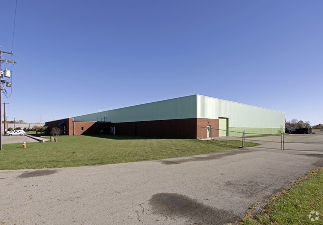
2060 Williams Rd
Columbus
Matthews Survey Congress Lands
Columbus, OH
2060 WILLIAMS RD. R22 T4 S12 13.948 ACRES
530-111821
Franklin
Warehouse
Ohio
2024
1
2025
18.51 AC
008812
Southeast
72,399 SF
DEMOGRAPHICS near 2060 Williams Rd
1 mile
3 mile
5 mile
2024 Total Population
4,936
47,246
165,685
2029 Population
4,863
47,500
167,040
Pop Growth 2024-2029
(1.48%)
+ 0.54%
+ 0.82%
Average Age
38
39
38
2024 Total Households
1,905
18,649
68,212
HH Growth 2024-2029
(1.47%)
+ 0.58%
+ 0.82%
Median Household Inc
$66,205
$56,620
$53,774
Avg Household Size
2.60
2.50
2.30
2024 Avg HH Vehicles
2.00
2.00
2.00
Median Home Value
$159,041
$147,227
$172,734
Median Year Built
1984
1973
1963
Nearby Places
Map Layers
Map Styles
 Street
 Aerial
Transit
 Traffic
 Biking
Places
Listings with unknown addresses are not visible on the map
- Restaurants
- Banks
- Shops
- Fitness
- Groceries
PUBLIC TRANSPORTATION
AIRPORT
Rickenbacker International
Drive
Walk
Distance
Rickenbacker International
10 min
5.5 mi
John Glenn Columbus International
Drive
Walk
Distance
John Glenn Columbus International
19 min
10.6 mi
Freight Ports
Port of Toledo
Drive
Walk
Distance
Port of Toledo
196 min
152.4 mi
SALE & LEASE HISTORY
LISTING DATE
SALE/LEASE

Jan 22, 2025
For Lease
Nearby Properties
Address
Land Use
TOTAL SIZE
Lot Size
Zoning
Address
Land Use
TOTAL SIZE
Lot Size
Zoning
471,215 SF
49.74 AC
Address
Land Use
TOTAL SIZE
Lot Size
Zoning
1,021,020 SF
68.44 AC
Address
Land Use
TOTAL SIZE
Lot Size
Zoning
785,854 SF
30.85 AC
Address
Land Use
TOTAL SIZE
Lot Size
Zoning
541,910 SF
36.84 AC
Address
Land Use
TOTAL SIZE
Lot Size
Zoning
743,315 SF
42.17 AC
Address
Land Use
TOTAL SIZE
Lot Size
Zoning
130,865 SF
9.97 AC
Address
Land Use
TOTAL SIZE
Lot Size
Zoning
655,288 SF
40.76 AC
Address
Land Use
TOTAL SIZE
Lot Size
Zoning
705,600 SF
43.41 AC
Address
Land Use
TOTAL SIZE
Lot Size
Zoning
737,054 SF
37.15 AC
Address
Land Use
TOTAL SIZE
Lot Size
Zoning
250,174 SF
178.12 AC
Address
Land Use
TOTAL SIZE
Lot Size
Zoning
642,331 SF
25.16 AC
Address
Land Use
TOTAL SIZE
Lot Size
Zoning
478,544 SF
23.04 AC
Address
Land Use
TOTAL SIZE
Lot Size
Zoning
478,544 SF
24.25 AC
Address
Land Use
TOTAL SIZE
Lot Size
Zoning
462,840 SF
27.07 AC
Address
Land Use
TOTAL SIZE
Lot Size
Zoning
483,620 SF
28.80 AC
Address
Land Use
TOTAL SIZE
Lot Size
Zoning
107,200 SF
24.72 AC
Address
Land Use
TOTAL SIZE
Lot Size
Zoning
107,676 SF
14.15 AC
Address
Land Use
TOTAL SIZE
Lot Size
Zoning
352,500 SF
20.75 AC
Address
Land Use
TOTAL SIZE
Lot Size
Zoning
516,025 SF
24.18 AC
Address
Land Use
TOTAL SIZE
Lot Size
Zoning
389,476 SF
18.84 AC
Address
Land Use
TOTAL SIZE
Lot Size
Zoning
406,364 SF
22.03 AC
Address
Land Use
TOTAL SIZE
Lot Size
Zoning
455,654 SF
24.55 AC
Address
Land Use
TOTAL SIZE
Lot Size
Zoning
311,190 SF
21.90 AC
Address
Land Use
TOTAL SIZE
Lot Size
Zoning
494,823 SF
28.93 AC
Address
Land Use
TOTAL SIZE
Lot Size
Zoning
257,400 SF
18.71 AC
Address
Land Use
TOTAL SIZE
Lot Size
Zoning
235,600 SF
11.25 AC
Address
Land Use
TOTAL SIZE
Lot Size
Zoning
604,078 SF
50.18 AC
Address
Land Use
TOTAL SIZE
Lot Size
Zoning
386,400 SF
21.24 AC
Address
Land Use
TOTAL SIZE
Lot Size
Zoning
324,000 SF
20.91 AC
Address
Land Use
TOTAL SIZE
Lot Size
Zoning
115,095 SF
14.02 AC
The World's #1 Commercial Real Estate Marketplace
Connect with us
© 2026 CoStar Group
The information above has been obtained from sources believed reliable. While we do not doubt its accuracy we have not verified it and make no guarantee, warranty or representation about it. It is your responsibility to independently confirm its accuracy and completeness. Any projections, opinions, assumptions, or estimates used are for example only and do not represent the current or future performance of the property. The value of this transaction to you depends on tax and other factors which should be evaluated by your tax, financial, and legal advisors. You and your advisors should conduct a careful, independent investigation of the property to determine to your satisfaction the suitability of the property for your needs.