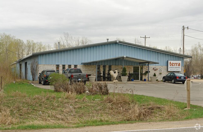
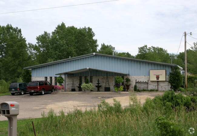
Property Record
20600 Kenrick Ave, Lakeville, MN 55044

NEARBY LISTINGS FOR SALE OR LEASE
Property Detail
20600 Kenrick Ave
22-02500-51-010
010000 2511421 PT OF N 1/2 OF SW 1/4 BEG E R/W HGWY 65 & S R/W RR S ON E R/W HGWY 150 FT TO BEG E AT RT ANG 600 FT S PARR HGWY R/W 726 FT W AT RT ANG 600FT TO R/W HGWY N ON R/W HGWY TO BEG SECTION 25 TWN 114 RANGE 21
Industrialgeneral
Dakota
X
Minnesota
27037C0193E
10
2024
10 AC
2024
South Central
060835
Minneapolis/St Paul
20,920 SF
Minneapolis-St. Paul-Bloomington, MN-WI
DEMOGRAPHICS near 20600 Kenrick Ave
1 Mile
3 Mile
5 Mile
2024 Total Population
2,610
27,191
61,074
2029 Population
2,648
28,065
63,284
Pop Growth 2024-2029
+ 1.46%
+ 3.21%
+ 3.62%
Average Age
38
38
38
2024 Total Households
850
9,298
20,907
HH Growth 2024-2029
+ 1.41%
+ 3.29%
+ 3.72%
Median Household Inc
$153,588
$124,978
$124,102
Avg Household Size
3.10
2.90
2.90
2024 Avg HH Vehicles
2.00
2.00
2.00
Median Home Value
$438,351
$435,170
$418,993
Median Year Built
1997
1999
1998
Nearby Places
Map Layers
Map Styles
 Street
 Aerial
- Restaurants
- Banks
- Shops
- Fitness
- Groceries
PUBLIC TRANSPORTATION
AIRPORT
Minneapolis-St Paul International/Wold-Chamberlain
DRIVE
WALK
Distance
Minneapolis-St Paul International/Wold-Chamberlain
28 min
20.8 mi
Nearby Properties
Address
Land Use
TOTAL SIZE
Lot Size
Zoning
Address
Land Use
TOTAL SIZE
Lot Size
Zoning
749,550 SF
71.74 AC
Address
Land Use
TOTAL SIZE
Lot Size
Zoning
286,137 SF
7.96 AC
Address
Land Use
TOTAL SIZE
Lot Size
Zoning
512,208 SF
90.38 AC
Address
Land Use
TOTAL SIZE
Lot Size
Zoning
355,380 SF
75.32 AC
Address
Land Use
TOTAL SIZE
Lot Size
Zoning
292,384 SF
39.16 AC
Address
Land Use
TOTAL SIZE
Lot Size
Zoning
342,606 SF
18.21 AC
Address
Land Use
TOTAL SIZE
Lot Size
Zoning
245,486 SF
5.29 AC
Address
Land Use
TOTAL SIZE
Lot Size
Zoning
107,036 SF
1.51 AC
Address
Land Use
TOTAL SIZE
Lot Size
Zoning
146,451 SF
10.63 AC
Address
Land Use
TOTAL SIZE
Lot Size
Zoning
179,859 SF
43.48 AC
Address
Land Use
TOTAL SIZE
Lot Size
Zoning
282,100 SF
18.86 AC
Address
Land Use
TOTAL SIZE
Lot Size
Zoning
191,090 SF
34.53 AC
Address
Land Use
TOTAL SIZE
Lot Size
Zoning
103,070 SF
10.76 AC
Address
Land Use
TOTAL SIZE
Lot Size
Zoning
172,249 SF
69.47 AC
Address
Land Use
TOTAL SIZE
Lot Size
Zoning
139,772 SF
3.15 AC
Address
Land Use
TOTAL SIZE
Lot Size
Zoning
157,593 SF
11.10 AC
Address
Land Use
TOTAL SIZE
Lot Size
Zoning
168,000 SF
14.31 AC
Address
Land Use
TOTAL SIZE
Lot Size
Zoning
183,049 SF
15.23 AC
Address
Land Use
TOTAL SIZE
Lot Size
Zoning
187,993 SF
21.88 AC
Address
Land Use
TOTAL SIZE
Lot Size
Zoning
121,600 SF
27.55 AC
Address
Land Use
TOTAL SIZE
Lot Size
Zoning
130,180 SF
9.01 AC
Address
Land Use
TOTAL SIZE
Lot Size
Zoning
151,109 SF
14.55 AC
Address
Land Use
TOTAL SIZE
Lot Size
Zoning
53,022 SF
11.89 AC
Address
Land Use
TOTAL SIZE
Lot Size
Zoning
109,440 SF
8.92 AC
Address
Land Use
TOTAL SIZE
Lot Size
Zoning
93,883 SF
4.17 AC
Address
Land Use
TOTAL SIZE
Lot Size
Zoning
78,220 SF
5.96 AC
The World's #1 Commercial Real Estate Marketplace
Connect with us
© 2026 CoStar Group
The information above has been obtained from sources believed reliable. While we do not doubt its accuracy we have not verified it and make no guarantee, warranty or representation about it. It is your responsibility to independently confirm its accuracy and completeness. Any projections, opinions, assumptions, or estimates used are for example only and do not represent the current or future performance of the property. The value of this transaction to you depends on tax and other factors which should be evaluated by your tax, financial, and legal advisors. You and your advisors should conduct a careful, independent investigation of the property to determine to your satisfaction the suitability of the property for your needs.