Property Record
20603 Clay Rd, Katy, TX 77449
NEARBY LISTINGS FOR SALE OR LEASE
-
-
View all Katy listings for sale on LoopNet.com
Property Detail
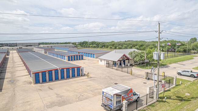
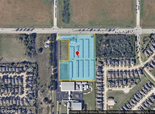
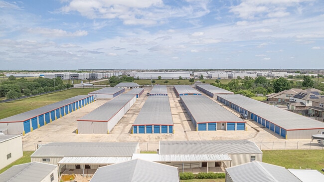
20603 Clay Rd
0460870000063
Abst 986 E Probert
Outdoorrecreationbeachmountaindesert
TR 1B-2 ABST 986 E PROBERT
X
Harris
48201C0605M
Texas
2024
5.97 AC
2025
Katy/Grand Parkway West
542305
Houston
95,126 SF
Houston-Pasadena-The Woodlands, TX
DEMOGRAPHICS near 20603 Clay Rd
1 Mile
3 Mile
5 Mile
2024 Total Population
18,438
139,711
318,633
2029 Population
19,047
143,538
327,711
Pop Growth 2024-2029
+ 3.30%
+ 2.74%
+ 2.85%
Average Age
34
34
35
2024 Total Households
5,171
42,072
100,331
HH Growth 2024-2029
+ 3.23%
+ 2.64%
+ 2.79%
Median Household Inc
$84,073
$79,890
$83,407
Avg Household Size
3.50
3.30
3.10
2024 Avg HH Vehicles
2.00
2.00
2.00
Median Home Value
$210,469
$211,630
$225,915
Median Year Built
2006
2005
2003
Nearby Places
Map Layers
Map Styles
 Street
 Aerial
- Restaurants
- Banks
- Shops
- Fitness
- Groceries
PUBLIC TRANSPORTATION
AIRPORT
George Bush Intcntl/Houston
DRIVE
WALK
Distance
George Bush Intcntl/Houston
46 min
34.1 mi
Freight Ports
Port of Houston
DRIVE
WALK
Distance
Port of Houston
52 min
35.9 mi
SALE & LEASE HISTORY
LISTING DATE
SALE/LEASE

May 20, 2025
For Sale
Nearby Properties
Address
Land Use
TOTAL SIZE
Lot Size
Zoning
Address
Land Use
TOTAL SIZE
Lot Size
Zoning
807,360 SF
54.15 AC
Address
Land Use
TOTAL SIZE
Lot Size
Zoning
838,700 SF
36.68 AC
Address
Land Use
TOTAL SIZE
Lot Size
Zoning
439,347 SF
13.50 AC
Address
Land Use
TOTAL SIZE
Lot Size
Zoning
891,129 SF
44.39 AC
Address
Land Use
TOTAL SIZE
Lot Size
Zoning
339,835 SF
12.09 AC
Address
Land Use
TOTAL SIZE
Lot Size
Zoning
343,605 SF
11.90 AC
Address
Land Use
TOTAL SIZE
Lot Size
Zoning
324,201 SF
12.39 AC
Address
Land Use
TOTAL SIZE
Lot Size
Zoning
290,973 SF
15 AC
Address
Land Use
TOTAL SIZE
Lot Size
Zoning
347,834 SF
15.25 AC
Address
Land Use
TOTAL SIZE
Lot Size
Zoning
272,033 SF
12.74 AC
Address
Land Use
TOTAL SIZE
Lot Size
Zoning
335,899 SF
12.62 AC
Address
Land Use
TOTAL SIZE
Lot Size
Zoning
395,495 SF
13.83 AC
Address
Land Use
TOTAL SIZE
Lot Size
Zoning
331,263 SF
11.36 AC
Address
Land Use
TOTAL SIZE
Lot Size
Zoning
266,532 SF
6.45 AC
Address
Land Use
TOTAL SIZE
Lot Size
Zoning
292,645 SF
12.71 AC
Address
Land Use
TOTAL SIZE
Lot Size
Zoning
439,808 SF
23.75 AC
Address
Land Use
TOTAL SIZE
Lot Size
Zoning
290,607 SF
14.50 AC
Address
Land Use
TOTAL SIZE
Lot Size
Zoning
385,744 SF
25.88 AC
Address
Land Use
TOTAL SIZE
Lot Size
Zoning
236,406 SF
11.40 AC
Address
Land Use
TOTAL SIZE
Lot Size
Zoning
367,873 SF
15.75 AC
Address
Land Use
TOTAL SIZE
Lot Size
Zoning
305,624 SF
Address
Land Use
TOTAL SIZE
Lot Size
Zoning
375,152 SF
19.57 AC
Address
Land Use
TOTAL SIZE
Lot Size
Zoning
262,174 SF
11.64 AC
Address
Land Use
TOTAL SIZE
Lot Size
Zoning
334,971 SF
18.43 AC
Address
Land Use
TOTAL SIZE
Lot Size
Zoning
262,943 SF
11.51 AC
Address
Land Use
TOTAL SIZE
Lot Size
Zoning
131,544 SF
19.04 AC
Address
Land Use
TOTAL SIZE
Lot Size
Zoning
235,154 SF
13 AC
Address
Land Use
TOTAL SIZE
Lot Size
Zoning
347,192 SF
16.10 AC
Address
Land Use
TOTAL SIZE
Lot Size
Zoning
693,781 SF
6.86 AC
Address
Land Use
TOTAL SIZE
Lot Size
Zoning
420,370 SF
17.05 AC
The World's #1 Commercial Real Estate Marketplace
Connect with us
© 2026 CoStar Group
The information above has been obtained from sources believed reliable. While we do not doubt its accuracy we have not verified it and make no guarantee, warranty or representation about it. It is your responsibility to independently confirm its accuracy and completeness. Any projections, opinions, assumptions, or estimates used are for example only and do not represent the current or future performance of the property. The value of this transaction to you depends on tax and other factors which should be evaluated by your tax, financial, and legal advisors. You and your advisors should conduct a careful, independent investigation of the property to determine to your satisfaction the suitability of the property for your needs.