Property Record
2061 Highway 52, Moncks Corner, SC 29461
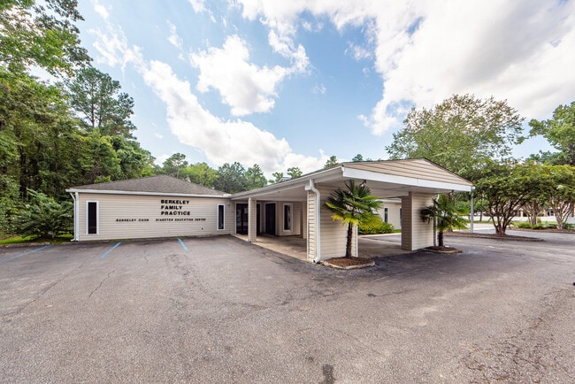

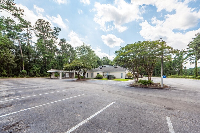
This Property Is For Sale
Property Detail
2061 Highway 52
181-00-01-028
ASSESSMENT DISTRICT: 961DOCTOR OFFICE(SECT 15 PG 20)
Medicalbuilding
Berkeley
BERKELEY C
South Carolina
B and X Area of moderate flood hazard, usually the area between the limits of the 100-year and 500-year floods.
2.06 AC
2025
Outlying Berkeley County
2025
Charleston/N Charleston
020601
Charleston-North Charleston, SC
16,605 SF
NEARBY LISTINGS FOR SALE OR LEASE
-
-
View all Moncks Corner listings for sale on LoopNet.com
DEMOGRAPHICS near 2061 Highway 52
1 mile
3 mile
5 mile
2025 Total Population
1,207
17,285
52,212
2030 Population
1,360
19,561
59,509
Pop Growth 2025-2030
+ 12.68%
+ 13.17%
+ 13.98%
Average Age
38
37
38
2025 Total Households
430
5,963
18,454
HH Growth 2025-2030
+ 13.02%
+ 13.65%
+ 14.34%
Median Household Inc
$93,469
$96,332
$92,628
Avg Household Size
2.80
2.90
2.80
2025 Avg HH Vehicles
3.00
2.00
2.00
Median Home Value
$330,184
$345,844
$355,576
Median Year Built
2003
2008
2010
Nearby Places
Map Layers
Map Styles
 Street
 Aerial
Layers
 Traffic
 Biking
Places
Listings with unknown addresses are not visible on the map
- Restaurants
- Banks
- Shops
- Fitness
- Groceries
PUBLIC TRANSPORTATION
AIRPORT
Charleston AFB/International
Drive
Walk
Distance
Charleston AFB/International
30 min
20.4 mi
Freight Ports
North Charleston Terminal
Drive
Walk
Distance
North Charleston Terminal
24 min
18.8 mi
Nearby Properties
Address
Land Use
TOTAL SIZE
Lot Size
Zoning
Address
Land Use
TOTAL SIZE
Lot Size
Zoning
615,000 SF
85.05 AC
Address
Land Use
TOTAL SIZE
Lot Size
Zoning
96,375 SF
49.17 AC
MONCKS COR
Address
Land Use
TOTAL SIZE
Lot Size
Zoning
200,772 SF
30.94 AC
BERKELEY C
Address
Land Use
TOTAL SIZE
Lot Size
Zoning
93,800 SF
15 AC
BERKELEY C
Address
Land Use
TOTAL SIZE
Lot Size
Zoning
83,500 SF
6 AC
BERKELEY C
Address
Land Use
TOTAL SIZE
Lot Size
Zoning
54,600 SF
21.23 AC
BERKELEY C
Address
Land Use
TOTAL SIZE
Lot Size
Zoning
3,000 SF
130.80 AC
Address
Land Use
TOTAL SIZE
Lot Size
Zoning
18,200 SF
6 AC
MONCKS COR
Address
Land Use
TOTAL SIZE
Lot Size
Zoning
7,810 SF
1.24 AC
MONCKS COR
Address
Land Use
TOTAL SIZE
Lot Size
Zoning
4,000 SF
12.83 AC
BERKELEY C
Address
Land Use
TOTAL SIZE
Lot Size
Zoning
6,308 SF
6.14 AC
BERKELEY C
Address
Land Use
TOTAL SIZE
Lot Size
Zoning
4,992 SF
1.53 AC
MONCKS COR
Address
Land Use
TOTAL SIZE
Lot Size
Zoning
46.46 AC
BERKELEY C
Address
Land Use
TOTAL SIZE
Lot Size
Zoning
20,730 SF
12.58 AC
BERKELEY C
Address
Land Use
TOTAL SIZE
Lot Size
Zoning
12,180 SF
5.07 AC
MONCKS COR
Address
Land Use
TOTAL SIZE
Lot Size
Zoning
21.60 AC
BERKELEY C
Address
Land Use
TOTAL SIZE
Lot Size
Zoning
10,780 SF
1.50 AC
MONCKS COR
Address
Land Use
TOTAL SIZE
Lot Size
Zoning
2,116 SF
MONCKS COR
Address
Land Use
TOTAL SIZE
Lot Size
Zoning
1,131 SF
22 AC
Address
Land Use
TOTAL SIZE
Lot Size
Zoning
4,002 SF
0.87 AC
MONCKS COR
Address
Land Use
TOTAL SIZE
Lot Size
Zoning
27.88 AC
MONCKS COR
Address
Land Use
TOTAL SIZE
Lot Size
Zoning
3,000 SF
154.36 AC
MONCKS COR
Address
Land Use
TOTAL SIZE
Lot Size
Zoning
9,000 SF
0.99 AC
MONCKS COR
Address
Land Use
TOTAL SIZE
Lot Size
Zoning
31,920 SF
9.71 AC
BERKELEY C
Address
Land Use
TOTAL SIZE
Lot Size
Zoning
17.60 AC
MONCKS COR
Address
Land Use
TOTAL SIZE
Lot Size
Zoning
2,549 SF
0.77 AC
MONCKS COR
Address
Land Use
TOTAL SIZE
Lot Size
Zoning
19,166 SF
177.36 AC
BERKELEY C
Address
Land Use
TOTAL SIZE
Lot Size
Zoning
17,536 SF
4.89 AC
BERKELEY C
The World's #1 Commercial Real Estate Marketplace
Connect with us
© 2026 CoStar Group
The information above has been obtained from sources believed reliable. While we do not doubt its accuracy we have not verified it and make no guarantee, warranty or representation about it. It is your responsibility to independently confirm its accuracy and completeness. Any projections, opinions, assumptions, or estimates used are for example only and do not represent the current or future performance of the property. The value of this transaction to you depends on tax and other factors which should be evaluated by your tax, financial, and legal advisors. You and your advisors should conduct a careful, independent investigation of the property to determine to your satisfaction the suitability of the property for your needs.