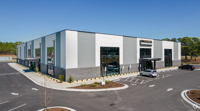
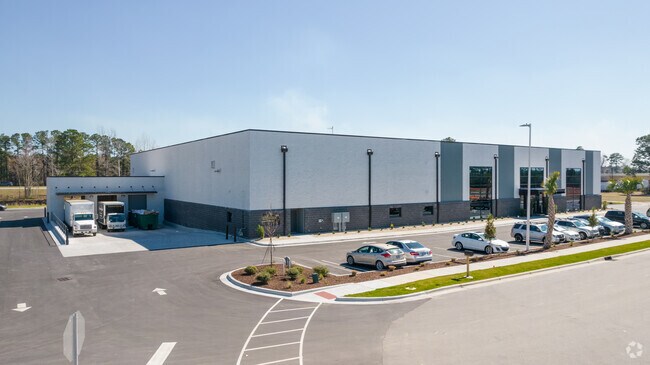
Property Record
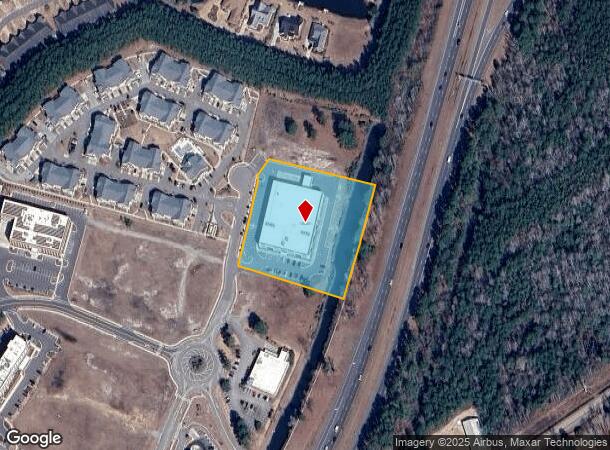
2062 Olde Regent Way, Leland, NC 28451
NEARBY LISTINGS FOR SALE OR LEASE
-
-
View all Leland listings for sale on LoopNet.com
Property Detail
2062 Olde Regent Way
Myrtle Beach-Conway-North Myrtle Beach, SC-NC
Recombination Of Lots 15 And 16
037MI001
L-15R 3.12AC WATERFORD COMMERCIAL PL 125/28
Departmentstore
Brunswick
X
North Carolina
3720219700K
15r
2024
3.12 AC
2025
Leland
020105
Wilmington
45,074 SF
DEMOGRAPHICS near 2062 Olde Regent Way
1 Mile
3 Mile
5 Mile
2024 Total Population
4,645
25,419
54,722
2029 Population
5,982
32,770
67,099
Pop Growth 2024-2029
+ 28.78%
+ 28.92%
+ 22.62%
Average Age
45
45
43
2024 Total Households
2,117
10,762
24,521
HH Growth 2024-2029
+ 28.58%
+ 28.79%
+ 22.00%
Median Household Inc
$74,650
$73,941
$64,573
Avg Household Size
2.20
2.30
2.20
2024 Avg HH Vehicles
2.00
2.00
2.00
Median Home Value
$326,369
$291,373
$280,484
Median Year Built
2006
2006
2001
Nearby Places
Map Layers
Map Styles
 Street
 Aerial
- Restaurants
- Banks
- Shops
- Fitness
- Groceries
PUBLIC TRANSPORTATION
AIRPORT
Wilmington International
DRIVE
WALK
Distance
Wilmington International
24 min
12.2 mi
Freight Ports
Port of Wilmington
DRIVE
WALK
Distance
Port of Wilmington
15 min
7.9 mi
Nearby Properties
Address
Land Use
TOTAL SIZE
Lot Size
Zoning
Address
Land Use
TOTAL SIZE
Lot Size
Zoning
207,055 SF
28.96 AC
CBD
Address
Land Use
TOTAL SIZE
Lot Size
Zoning
1,495 SF
22.50 AC
MF
Address
Land Use
TOTAL SIZE
Lot Size
Zoning
25,392 SF
15.91 AC
MF
Address
Land Use
TOTAL SIZE
Lot Size
Zoning
50,441 SF
19.08 AC
MF
Address
Land Use
TOTAL SIZE
Lot Size
Zoning
31,509 SF
24.06 AC
T4O
Address
Land Use
TOTAL SIZE
Lot Size
Zoning
23,868 SF
15.20 AC
CLD
Address
Land Use
TOTAL SIZE
Lot Size
Zoning
206,487 SF
10.68 AC
MF
Address
Land Use
TOTAL SIZE
Lot Size
Zoning
16,152 SF
25.44 AC
MF
Address
Land Use
TOTAL SIZE
Lot Size
Zoning
170,188 SF
59.74 AC
OI
Address
Land Use
TOTAL SIZE
Lot Size
Zoning
448.80 AC
MF
Address
Land Use
TOTAL SIZE
Lot Size
Zoning
10,122 SF
8.46 AC
MF
Address
Land Use
TOTAL SIZE
Lot Size
Zoning
22,785 SF
10.19 AC
I
Address
Land Use
TOTAL SIZE
Lot Size
Zoning
103,751 SF
26.88 AC
R75
Address
Land Use
TOTAL SIZE
Lot Size
Zoning
11,158 SF
2.47 AC
T5
Address
Land Use
TOTAL SIZE
Lot Size
Zoning
204,120 SF
16.94 AC
LI
Address
Land Use
TOTAL SIZE
Lot Size
Zoning
25,098 SF
9.54 AC
T4O
Address
Land Use
TOTAL SIZE
Lot Size
Zoning
336,085 SF
59.02 AC
HI
Address
Land Use
TOTAL SIZE
Lot Size
Zoning
28,198 SF
6.50 AC
MF
Address
Land Use
TOTAL SIZE
Lot Size
Zoning
81,572 SF
5.53 AC
MF
Address
Land Use
TOTAL SIZE
Lot Size
Zoning
178,677 SF
23.66 AC
C2
Address
Land Use
TOTAL SIZE
Lot Size
Zoning
48,662 SF
11.45 AC
C2
Address
Land Use
TOTAL SIZE
Lot Size
Zoning
106,450 SF
36.50 AC
OI
Address
Land Use
TOTAL SIZE
Lot Size
Zoning
15,132 SF
3.28 AC
T4O
Address
Land Use
TOTAL SIZE
Lot Size
Zoning
54,900 SF
3.55 AC
C2
Address
Land Use
TOTAL SIZE
Lot Size
Zoning
27,930 SF
2.23 AC
T4O
Address
Land Use
TOTAL SIZE
Lot Size
Zoning
Address
Land Use
TOTAL SIZE
Lot Size
Zoning
43,792 SF
2.58 AC
C2
Address
Land Use
TOTAL SIZE
Lot Size
Zoning
56,482 SF
1.68 AC
C2
Address
Land Use
TOTAL SIZE
Lot Size
Zoning
1,930 SF
6.16 AC
PUD
Address
Land Use
TOTAL SIZE
Lot Size
Zoning
22,344 SF
4 AC
I
The World's #1 Commercial Real Estate Marketplace
Connect with us
© 2025 CoStar Group
The information above has been obtained from sources believed reliable. While we do not doubt its accuracy we have not verified it and make no guarantee, warranty or representation about it. It is your responsibility to independently confirm its accuracy and completeness. Any projections, opinions, assumptions, or estimates used are for example only and do not represent the current or future performance of the property. The value of this transaction to you depends on tax and other factors which should be evaluated by your tax, financial, and legal advisors. You and your advisors should conduct a careful, independent investigation of the property to determine to your satisfaction the suitability of the property for your needs.