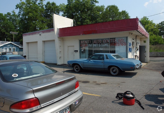
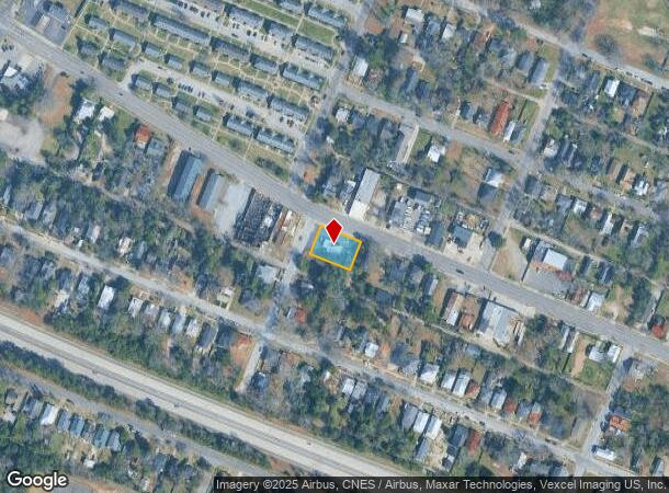
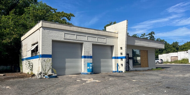
Property Record
2064 Broad St, Augusta, GA 30904
NEARBY LISTINGS FOR SALE OR LEASE
Property Detail
2064 Broad St
0273140000
2064 BROAD ST
Commercialacreage
Richmond
X
Georgia
13245C0110G
0.26 AC
2025
Downtown Augusta
2025
Augusta/Richmond County
000200
Augusta-Richmond County, GA-SC
1,460 SF
DEMOGRAPHICS near 2064 Broad St
1 Mile
3 Mile
5 Mile
2024 Total Population
7,678
59,705
128,989
2029 Population
7,840
60,805
131,219
Pop Growth 2024-2029
+ 2.11%
+ 1.84%
+ 1.73%
Average Age
40
41
39
2024 Total Households
3,490
27,799
57,093
HH Growth 2024-2029
+ 2.06%
+ 1.80%
+ 1.51%
Median Household Inc
$32,404
$46,644
$48,162
Avg Household Size
2.10
2.00
2.20
2024 Avg HH Vehicles
1.00
1.00
2.00
Median Home Value
$183,508
$187,918
$169,657
Median Year Built
1953
1966
1972
Nearby Places
Map Layers
Map Styles
 Street
 Aerial
- Restaurants
- Banks
- Shops
- Fitness
- Groceries
PUBLIC TRANSPORTATION
AIRPORT
Augusta Regional at Bush Field
DRIVE
WALK
Distance
Augusta Regional at Bush Field
22 min
10.0 mi
Freight Ports
Georgia Ports - Savannah
DRIVE
WALK
Distance
Georgia Ports - Savannah
159 min
121.7 mi
SALE & LEASE HISTORY
LISTING DATE
SALE/LEASE

Jul 25, 2024
For Sale
Nearby Properties
Address
Land Use
TOTAL SIZE
Lot Size
Zoning
Address
Land Use
TOTAL SIZE
Lot Size
Zoning
954,084 SF
18.30 AC
B-2
Address
Land Use
TOTAL SIZE
Lot Size
Zoning
8,993 SF
351.84 AC
R-1_B-2
Address
Land Use
TOTAL SIZE
Lot Size
Zoning
52,025 SF
6.46 AC
Address
Land Use
TOTAL SIZE
Lot Size
Zoning
627,990 SF
20 AC
P-1
Address
Land Use
TOTAL SIZE
Lot Size
Zoning
1,100 SF
97.38 AC
R-1A
Address
Land Use
TOTAL SIZE
Lot Size
Zoning
197,726 SF
2.93 AC
B-2
Address
Land Use
TOTAL SIZE
Lot Size
Zoning
169,662 SF
3.09 AC
B-2
Address
Land Use
TOTAL SIZE
Lot Size
Zoning
4,214 SF
12.73 AC
LI_B-2
Address
Land Use
TOTAL SIZE
Lot Size
Zoning
202,994 SF
19.25 AC
P-1
Address
Land Use
TOTAL SIZE
Lot Size
Zoning
6,694 SF
17.75 AC
R-3B
Address
Land Use
TOTAL SIZE
Lot Size
Zoning
179,743 SF
9.52 AC
007
Address
Land Use
TOTAL SIZE
Lot Size
Zoning
33,784 SF
22.27 AC
B-2
Address
Land Use
TOTAL SIZE
Lot Size
Zoning
102,429 SF
7.31 AC
PUD
Address
Land Use
TOTAL SIZE
Lot Size
Zoning
255,834 SF
5.56 AC
B-1
Address
Land Use
TOTAL SIZE
Lot Size
Zoning
102,748 SF
22.60 AC
R-3B
Address
Land Use
TOTAL SIZE
Lot Size
Zoning
6,516 SF
15.33 AC
R-3B
Address
Land Use
TOTAL SIZE
Lot Size
Zoning
179,779 SF
5.91 AC
B-2
Address
Land Use
TOTAL SIZE
Lot Size
Zoning
1,000 SF
4.45 AC
Address
Land Use
TOTAL SIZE
Lot Size
Zoning
3,447 SF
16.67 AC
R-3B
Address
Land Use
TOTAL SIZE
Lot Size
Zoning
267,960 SF
2.13 AC
B-2
Address
Land Use
TOTAL SIZE
Lot Size
Zoning
61,769 SF
12.06 AC
B-2
Address
Land Use
TOTAL SIZE
Lot Size
Zoning
152,352 SF
1.51 AC
Address
Land Use
TOTAL SIZE
Lot Size
Zoning
114,153 SF
12.91 AC
B-2
Address
Land Use
TOTAL SIZE
Lot Size
Zoning
137,062 SF
4.45 AC
B-2
Address
Land Use
TOTAL SIZE
Lot Size
Zoning
127,728 SF
1.34 AC
B-2
Address
Land Use
TOTAL SIZE
Lot Size
Zoning
109,076 SF
4.23 AC
R-3C
Address
Land Use
TOTAL SIZE
Lot Size
Zoning
106,500 SF
1.41 AC
Address
Land Use
TOTAL SIZE
Lot Size
Zoning
25,504 SF
9.87 AC
B-2
Address
Land Use
TOTAL SIZE
Lot Size
Zoning
21,615 SF
207.78 AC
R-1
Address
Land Use
TOTAL SIZE
Lot Size
Zoning
2,355 SF
12.97 AC
B-2
The World's #1 Commercial Real Estate Marketplace
Connect with us
© 2025 CoStar Group
The information above has been obtained from sources believed reliable. While we do not doubt its accuracy we have not verified it and make no guarantee, warranty or representation about it. It is your responsibility to independently confirm its accuracy and completeness. Any projections, opinions, assumptions, or estimates used are for example only and do not represent the current or future performance of the property. The value of this transaction to you depends on tax and other factors which should be evaluated by your tax, financial, and legal advisors. You and your advisors should conduct a careful, independent investigation of the property to determine to your satisfaction the suitability of the property for your needs.