Property Record
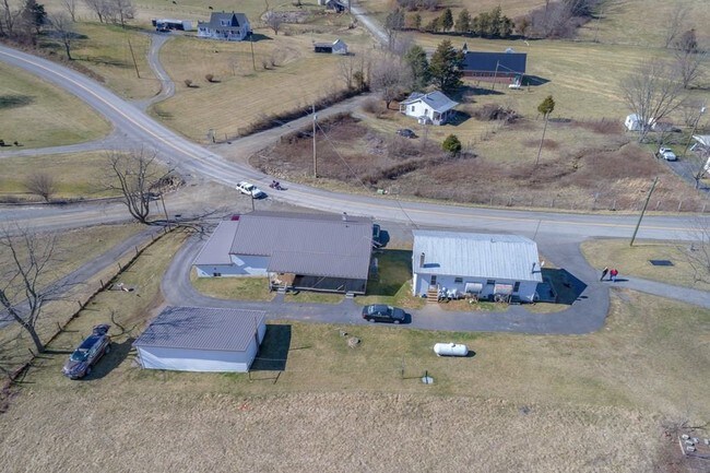
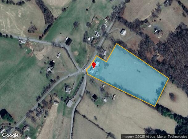
2067 Castleton Rd, Max Meadows, VA 24360
Property Detail
2067 Castleton Rd
Apartment
BETWEEN POPLAR CAMP & PATTERSON
X
Wythe
51155C0225H
Virginia
2024
5 AC
2024
Blacksburg & Wytheville
050402
Other Market Areas
3,660 SF
062-000-0000-0105
NEARBY LISTINGS FOR SALE OR LEASE
-
-
View all Max Meadows listings for sale on LoopNet.com
DEMOGRAPHICS near 2067 Castleton Rd
1 mile
3 mile
5 mile
2024 Total Population
237
1,512
3,540
2029 Population
235
1,500
3,525
Pop Growth 2024-2029
(0.84%)
(0.79%)
(0.42%)
Average Age
43
44
44
2024 Total Households
96
618
1,472
HH Growth 2024-2029
(1.04%)
(0.81%)
(0.48%)
Median Household Inc
$38,408
$43,420
$45,864
Avg Household Size
2.50
2.50
2.40
2024 Avg HH Vehicles
3.00
3.00
3.00
Median Home Value
$136,363
$134,269
$118,493
Median Year Built
1987
1990
1986
Nearby Places
Map Layers
Map Styles
 Street
 Aerial
Transit
 Traffic
 Biking
Places
Listings with unknown addresses are not visible on the map
- Restaurants
- Banks
- Shops
- Fitness
- Groceries
SALE & LEASE HISTORY
LISTING DATE
SALE/LEASE

Jul 09, 2018
For Sale
Nearby Properties
Address
Land Use
TOTAL SIZE
Lot Size
Zoning
Address
Land Use
TOTAL SIZE
Lot Size
Zoning
703.17 AC
Address
Land Use
TOTAL SIZE
Lot Size
Zoning
3,334 SF
13.22 AC
Address
Land Use
TOTAL SIZE
Lot Size
Zoning
8,911 SF
2.02 AC
Address
Land Use
TOTAL SIZE
Lot Size
Zoning
8,320 SF
1.66 AC
Address
Land Use
TOTAL SIZE
Lot Size
Zoning
57.85 AC
Address
Land Use
TOTAL SIZE
Lot Size
Zoning
1,000.55 AC
Address
Land Use
TOTAL SIZE
Lot Size
Zoning
816 SF
1,000.55 AC
Address
Land Use
TOTAL SIZE
Lot Size
Zoning
1,997 SF
433.08 AC
Address
Land Use
TOTAL SIZE
Lot Size
Zoning
2,108 SF
40.01 AC
Address
Land Use
TOTAL SIZE
Lot Size
Zoning
81.39 AC
Address
Land Use
TOTAL SIZE
Lot Size
Zoning
3,800 SF
153.94 AC
Address
Land Use
TOTAL SIZE
Lot Size
Zoning
98.28 AC
Address
Land Use
TOTAL SIZE
Lot Size
Zoning
126.82 AC
Address
Land Use
TOTAL SIZE
Lot Size
Zoning
Address
Land Use
TOTAL SIZE
Lot Size
Zoning
1,120 SF
235.87 AC
Address
Land Use
TOTAL SIZE
Lot Size
Zoning
Address
Land Use
TOTAL SIZE
Lot Size
Zoning
5.86 AC
Address
Land Use
TOTAL SIZE
Lot Size
Zoning
2,544 SF
53.25 AC
Address
Land Use
TOTAL SIZE
Lot Size
Zoning
Address
Land Use
TOTAL SIZE
Lot Size
Zoning
Address
Land Use
TOTAL SIZE
Lot Size
Zoning
74.84 AC
Address
Land Use
TOTAL SIZE
Lot Size
Zoning
Address
Land Use
TOTAL SIZE
Lot Size
Zoning
4,931 SF
40.97 AC
Address
Land Use
TOTAL SIZE
Lot Size
Zoning
6,680 SF
14.43 AC
Address
Land Use
TOTAL SIZE
Lot Size
Zoning
5,441 SF
8.32 AC
Address
Land Use
TOTAL SIZE
Lot Size
Zoning
4,106 SF
6.08 AC
Address
Land Use
TOTAL SIZE
Lot Size
Zoning
15.50 AC
Address
Land Use
TOTAL SIZE
Lot Size
Zoning
45.98 AC
Address
Land Use
TOTAL SIZE
Lot Size
Zoning
5,160 SF
5.81 AC
Address
Land Use
TOTAL SIZE
Lot Size
Zoning
3,102 SF
6.95 AC
The World's #1 Commercial Real Estate Marketplace
Connect with us
© 2026 CoStar Group
The information above has been obtained from sources believed reliable. While we do not doubt its accuracy we have not verified it and make no guarantee, warranty or representation about it. It is your responsibility to independently confirm its accuracy and completeness. Any projections, opinions, assumptions, or estimates used are for example only and do not represent the current or future performance of the property. The value of this transaction to you depends on tax and other factors which should be evaluated by your tax, financial, and legal advisors. You and your advisors should conduct a careful, independent investigation of the property to determine to your satisfaction the suitability of the property for your needs.