Property Record
2065 Route 37 E, Manchester, NJ 08759
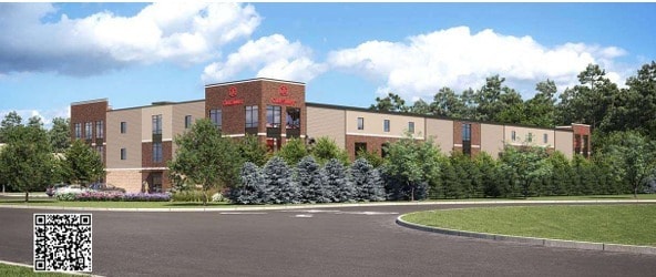
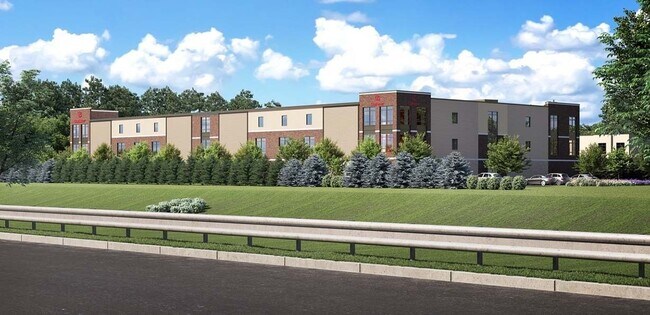

This Property Is For Sale
NEARBY LISTINGS FOR SALE OR LEASE
-
-
View all Manchester listings for sale on LoopNet.com
Property Detail
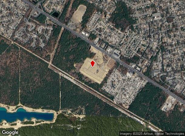
2065 Route 37 E
19-00044-0000-00015-01
6.579AC
Vacantlandnec
Ocean
X
New Jersey
34029C0168F
15.4
2024
6.58 AC
2025
Ocean County
720105
Northern New Jersey
2,922 SF
New York-Jersey City-White Plains, NY-NJ
DEMOGRAPHICS near 2065 Route 37 E
1 Mile
3 Mile
5 Mile
2024 Total Population
6,151
38,968
91,266
2029 Population
6,329
40,844
95,801
Pop Growth 2024-2029
+ 2.89%
+ 4.81%
+ 4.97%
Average Age
45
55
50
2024 Total Households
2,635
19,225
41,040
HH Growth 2024-2029
+ 1.44%
+ 4.23%
+ 4.22%
Median Household Inc
$67,371
$53,814
$56,496
Avg Household Size
2.20
1.90
2.10
2024 Avg HH Vehicles
2.00
2.00
2.00
Median Home Value
$230,546
$218,290
$238,834
Median Year Built
1985
1979
1981
Nearby Places
Map Layers
Map Styles
 Street
 Aerial
- Restaurants
- Banks
- Shops
- Fitness
- Groceries
Nearby Properties
Address
Land Use
TOTAL SIZE
Lot Size
Zoning
Address
Land Use
TOTAL SIZE
Lot Size
Zoning
1,065.50 AC
MI
Address
Land Use
TOTAL SIZE
Lot Size
Zoning
75,558 SF
43.30 AC
R15
Address
Land Use
TOTAL SIZE
Lot Size
Zoning
9,730 SF
98.31 AC
RC
Address
Land Use
TOTAL SIZE
Lot Size
Zoning
123,881 SF
93.73 AC
FAAF
Address
Land Use
TOTAL SIZE
Lot Size
Zoning
1,973 SF
22.84 AC
PRCD
Address
Land Use
TOTAL SIZE
Lot Size
Zoning
12,383 SF
39.07 AC
HD-3
Address
Land Use
TOTAL SIZE
Lot Size
Zoning
19,509 SF
717.61 AC
RC2
Address
Land Use
TOTAL SIZE
Lot Size
Zoning
52.06 AC
TC
Address
Land Use
TOTAL SIZE
Lot Size
Zoning
8.66 AC
RHB
Address
Land Use
TOTAL SIZE
Lot Size
Zoning
61,142 SF
23.53 AC
R40
Address
Land Use
TOTAL SIZE
Lot Size
Zoning
35,800 SF
24.53 AC
RHB
Address
Land Use
TOTAL SIZE
Lot Size
Zoning
71.59 AC
R10
Address
Land Use
TOTAL SIZE
Lot Size
Zoning
21,441 SF
54.88 AC
PORL
Address
Land Use
TOTAL SIZE
Lot Size
Zoning
115,528 SF
17.59 AC
SPLT
Address
Land Use
TOTAL SIZE
Lot Size
Zoning
14,432 SF
15.69 AC
RHB
Address
Land Use
TOTAL SIZE
Lot Size
Zoning
38,172 SF
7.36 AC
MF
Address
Land Use
TOTAL SIZE
Lot Size
Zoning
48,688 SF
9.60 AC
TC
Address
Land Use
TOTAL SIZE
Lot Size
Zoning
3.73 AC
R-2
Address
Land Use
TOTAL SIZE
Lot Size
Zoning
78,980 SF
4.88 AC
R40
Address
Land Use
TOTAL SIZE
Lot Size
Zoning
158 SF
23.51 AC
MP
Address
Land Use
TOTAL SIZE
Lot Size
Zoning
18,024 SF
5.94 AC
MF
Address
Land Use
TOTAL SIZE
Lot Size
Zoning
38,172 SF
10.61 AC
MF
Address
Land Use
TOTAL SIZE
Lot Size
Zoning
0.47 AC
RC
Address
Land Use
TOTAL SIZE
Lot Size
Zoning
72.96 AC
PR40
Address
Land Use
TOTAL SIZE
Lot Size
Zoning
5.73 AC
PRRC
Address
Land Use
TOTAL SIZE
Lot Size
Zoning
7,040 SF
5.69 AC
RHB
Address
Land Use
TOTAL SIZE
Lot Size
Zoning
4.70 AC
RC
Address
Land Use
TOTAL SIZE
Lot Size
Zoning
13,154 SF
167.85 AC
SPLT
Address
Land Use
TOTAL SIZE
Lot Size
Zoning
18,024 SF
6.96 AC
MF
Address
Land Use
TOTAL SIZE
Lot Size
Zoning
66,162 SF
7.38 AC
RHB
The World's #1 Commercial Real Estate Marketplace
Connect with us
© 2026 CoStar Group
The information above has been obtained from sources believed reliable. While we do not doubt its accuracy we have not verified it and make no guarantee, warranty or representation about it. It is your responsibility to independently confirm its accuracy and completeness. Any projections, opinions, assumptions, or estimates used are for example only and do not represent the current or future performance of the property. The value of this transaction to you depends on tax and other factors which should be evaluated by your tax, financial, and legal advisors. You and your advisors should conduct a careful, independent investigation of the property to determine to your satisfaction the suitability of the property for your needs.