Property Record
20672 Niobrara Blvd, La Salle, CO 80645
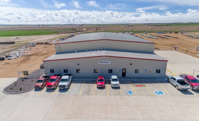

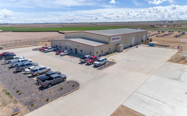
Property Detail
20672 Niobrara Blvd
Greeley, CO
L4 WELD COUNTY INDUSTRIAL PARK
R6785435
Weld
Warehouse
Colorado
B and X Area of moderate flood hazard, usually the area between the limits of the 100-year and 500-year floods.
4
2025
8.28 AC
2026
Weld County
001700
Denver
18,048 SF
NEARBY LISTINGS FOR SALE OR LEASE
-
-
View all La Salle listings for sale on LoopNet.com
DEMOGRAPHICS near 20672 Niobrara Blvd
1 mile
3 mile
5 mile
2025 Total Population
149
1,532
10,641
2030 Population
158
1,623
11,667
Pop Growth 2025-2030
+ 6.04%
+ 5.94%
+ 9.64%
Average Age
41
40
38
2025 Total Households
54
529
3,583
HH Growth 2025-2030
+ 7.41%
+ 6.43%
+ 9.91%
Median Household Inc
$84,375
$76,351
$82,694
Avg Household Size
2.70
2.90
2.90
2025 Avg HH Vehicles
3.00
3.00
3.00
Median Home Value
$450,000
$359,278
$355,295
Median Year Built
1972
1973
1994
Nearby Places
Map Layers
Map Styles
 Street
 Aerial
Layers
 Traffic
 Biking
Places
Listings with unknown addresses are not visible on the map
- Restaurants
- Banks
- Shops
- Fitness
- Groceries
SALE & LEASE HISTORY
LISTING DATE
SALE/LEASE

May 24, 2017
For Sale
Nearby Properties
Address
Land Use
TOTAL SIZE
Lot Size
Zoning
Address
Land Use
TOTAL SIZE
Lot Size
Zoning
132.20 AC
Address
Land Use
TOTAL SIZE
Lot Size
Zoning
30,095 SF
16.69 AC
Address
Land Use
TOTAL SIZE
Lot Size
Zoning
105,200 SF
4.13 AC
Address
Land Use
TOTAL SIZE
Lot Size
Zoning
15,256 SF
8.65 AC
Address
Land Use
TOTAL SIZE
Lot Size
Zoning
43,942 SF
5.03 AC
Address
Land Use
TOTAL SIZE
Lot Size
Zoning
20,276 SF
3.51 AC
Address
Land Use
TOTAL SIZE
Lot Size
Zoning
22,792 SF
19.53 AC
Address
Land Use
TOTAL SIZE
Lot Size
Zoning
71,344 SF
239.74 AC
Address
Land Use
TOTAL SIZE
Lot Size
Zoning
14,992 SF
9.05 AC
Address
Land Use
TOTAL SIZE
Lot Size
Zoning
15,150 SF
14.21 AC
Address
Land Use
TOTAL SIZE
Lot Size
Zoning
36,506 SF
469.50 AC
Address
Land Use
TOTAL SIZE
Lot Size
Zoning
38,782 SF
4.13 AC
Address
Land Use
TOTAL SIZE
Lot Size
Zoning
28,810 SF
9.98 AC
Address
Land Use
TOTAL SIZE
Lot Size
Zoning
12,685 SF
46.88 AC
Address
Land Use
TOTAL SIZE
Lot Size
Zoning
46,248 SF
118.17 AC
Address
Land Use
TOTAL SIZE
Lot Size
Zoning
14.47 AC
Address
Land Use
TOTAL SIZE
Lot Size
Zoning
9,600 SF
3.52 AC
Address
Land Use
TOTAL SIZE
Lot Size
Zoning
12,270 SF
34.50 AC
Address
Land Use
TOTAL SIZE
Lot Size
Zoning
5,321 SF
9.33 AC
Address
Land Use
TOTAL SIZE
Lot Size
Zoning
10,005 SF
6.94 AC
Address
Land Use
TOTAL SIZE
Lot Size
Zoning
34,470 SF
1.89 AC
Address
Land Use
TOTAL SIZE
Lot Size
Zoning
8,055 SF
4.99 AC
Address
Land Use
TOTAL SIZE
Lot Size
Zoning
5,000 SF
7.85 AC
Address
Land Use
TOTAL SIZE
Lot Size
Zoning
2,944 SF
6.96 AC
Address
Land Use
TOTAL SIZE
Lot Size
Zoning
7,520 SF
20 AC
Address
Land Use
TOTAL SIZE
Lot Size
Zoning
8,396 SF
100 AC
Address
Land Use
TOTAL SIZE
Lot Size
Zoning
9,100 SF
77.30 AC
Address
Land Use
TOTAL SIZE
Lot Size
Zoning
3,690 SF
0.45 AC
The World's #1 Commercial Real Estate Marketplace
Connect with us
© 2026 CoStar Group
The information above has been obtained from sources believed reliable. While we do not doubt its accuracy we have not verified it and make no guarantee, warranty or representation about it. It is your responsibility to independently confirm its accuracy and completeness. Any projections, opinions, assumptions, or estimates used are for example only and do not represent the current or future performance of the property. The value of this transaction to you depends on tax and other factors which should be evaluated by your tax, financial, and legal advisors. You and your advisors should conduct a careful, independent investigation of the property to determine to your satisfaction the suitability of the property for your needs.