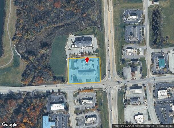
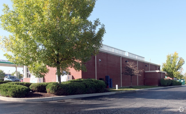
Property Record
2068 E Hadley Rd, Plainfield, IN 46168

NEARBY LISTINGS FOR SALE OR LEASE
Property Detail
2068 E Hadley Rd
32-15-01-300-002.000-012
PT SW 1-14-1E 2.23AC
Conveniencestore
Hendricks
X
Indiana
18097C0215F
2.23 AC
2024
Hendricks County
2024
Indianapolis
210608
Indianapolis-Carmel-Greenwood, IN
4,360 SF
DEMOGRAPHICS near 2068 E Hadley Rd
1 mile
3 mile
5 mile
2024 Total Population
2,006
26,880
75,700
2029 Population
2,227
29,960
82,175
Pop Growth 2024-2029
+ 11.02%
+ 11.46%
+ 8.55%
Average Age
43
40
39
2024 Total Households
790
10,068
27,678
HH Growth 2024-2029
+ 11.27%
+ 11.69%
+ 8.67%
Median Household Inc
$88,848
$72,761
$79,037
Avg Household Size
2.40
2.40
2.60
2024 Avg HH Vehicles
2.00
2.00
2.00
Median Home Value
$252,491
$227,702
$223,638
Median Year Built
1986
1983
1996
Nearby Places
Map Layers
Map Styles
 Street
 Aerial
Transit
 Traffic
 Biking
Places
Listings with unknown addresses are not visible on the map
- Restaurants
- Banks
- Shops
- Fitness
- Groceries
PUBLIC TRANSPORTATION
AIRPORT
Indianapolis International
Drive
Walk
Distance
Indianapolis International
13 min
6.3 mi
Nearby Properties
Address
Land Use
TOTAL SIZE
Lot Size
Zoning
Address
Land Use
TOTAL SIZE
Lot Size
Zoning
796,988 SF
48.51 AC
Address
Land Use
TOTAL SIZE
Lot Size
Zoning
950,625 SF
58.11 AC
Address
Land Use
TOTAL SIZE
Lot Size
Zoning
41.50 AC
Address
Land Use
TOTAL SIZE
Lot Size
Zoning
923,980 SF
60.08 AC
Address
Land Use
TOTAL SIZE
Lot Size
Zoning
822,500 SF
45.66 AC
Address
Land Use
TOTAL SIZE
Lot Size
Zoning
9,728 SF
23.10 AC
Address
Land Use
TOTAL SIZE
Lot Size
Zoning
799,264 SF
43.44 AC
Address
Land Use
TOTAL SIZE
Lot Size
Zoning
5,064 SF
25.50 AC
Address
Land Use
TOTAL SIZE
Lot Size
Zoning
750,820 SF
64.15 AC
Address
Land Use
TOTAL SIZE
Lot Size
Zoning
747,256 SF
41.32 AC
Address
Land Use
TOTAL SIZE
Lot Size
Zoning
720,000 SF
39.03 AC
Address
Land Use
TOTAL SIZE
Lot Size
Zoning
595,938 SF
35.31 AC
Address
Land Use
TOTAL SIZE
Lot Size
Zoning
51,884 SF
14.73 AC
Address
Land Use
TOTAL SIZE
Lot Size
Zoning
650,960 SF
31.95 AC
Address
Land Use
TOTAL SIZE
Lot Size
Zoning
651,610 SF
63.52 AC
Address
Land Use
TOTAL SIZE
Lot Size
Zoning
292,315 SF
28.97 AC
Address
Land Use
TOTAL SIZE
Lot Size
Zoning
635,585 SF
28.37 AC
Address
Land Use
TOTAL SIZE
Lot Size
Zoning
24.62 AC
Address
Land Use
TOTAL SIZE
Lot Size
Zoning
10,953 SF
18.52 AC
Address
Land Use
TOTAL SIZE
Lot Size
Zoning
518,536 SF
25.66 AC
Address
Land Use
TOTAL SIZE
Lot Size
Zoning
551,424 SF
31.39 AC
Address
Land Use
TOTAL SIZE
Lot Size
Zoning
599,744 SF
34.65 AC
Address
Land Use
TOTAL SIZE
Lot Size
Zoning
500,192 SF
33.15 AC
Address
Land Use
TOTAL SIZE
Lot Size
Zoning
595,100 SF
28.35 AC
Address
Land Use
TOTAL SIZE
Lot Size
Zoning
695,702 SF
39.68 AC
ZO03
Address
Land Use
TOTAL SIZE
Lot Size
Zoning
480,000 SF
40.60 AC
Address
Land Use
TOTAL SIZE
Lot Size
Zoning
4,514 SF
18.08 AC
Address
Land Use
TOTAL SIZE
Lot Size
Zoning
462,275 SF
25.83 AC
ZO01
Address
Land Use
TOTAL SIZE
Lot Size
Zoning
500,000 SF
28.58 AC
Address
Land Use
TOTAL SIZE
Lot Size
Zoning
357,000 SF
27.34 AC
The World's #1 Commercial Real Estate Marketplace
Connect with us
© 2026 CoStar Group
The information above has been obtained from sources believed reliable. While we do not doubt its accuracy we have not verified it and make no guarantee, warranty or representation about it. It is your responsibility to independently confirm its accuracy and completeness. Any projections, opinions, assumptions, or estimates used are for example only and do not represent the current or future performance of the property. The value of this transaction to you depends on tax and other factors which should be evaluated by your tax, financial, and legal advisors. You and your advisors should conduct a careful, independent investigation of the property to determine to your satisfaction the suitability of the property for your needs.