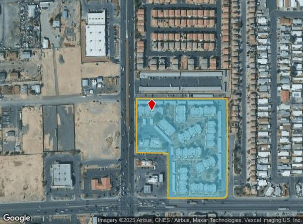
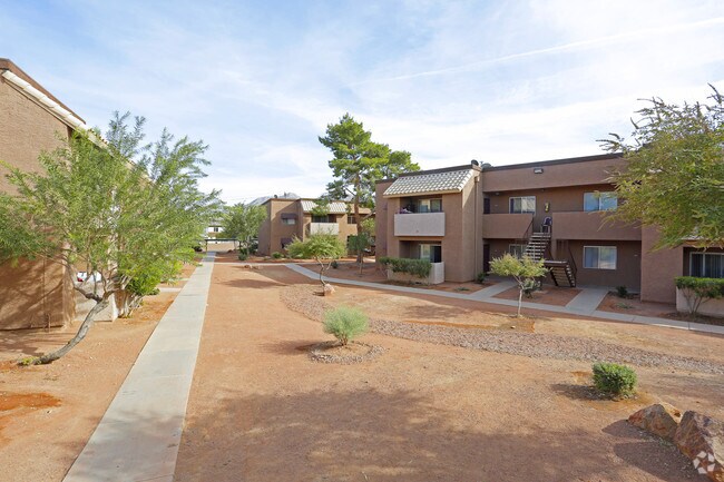
Property Record
2068 N Nellis Blvd, Las Vegas, NV 89115


NEARBY LISTINGS FOR SALE OR LEASE
Property Detail
2068 N Nellis Blvd
Las Vegas-Henderson-Paradise, NV
Parcel Map File 14 Page 49
140-21-201-009
PARCEL MAP FILE 14 PAGE 49 LOT 2 & PT SW4 NW4 SEC 21 20 62
Apartment
Clark
X
Nevada
32003C2185F
2
2025
7.01 AC
2025
Sunrise Manor
006201
Las Vegas
1,880 SF
DEMOGRAPHICS near 2068 N Nellis Blvd
1 Mile
3 Mile
5 Mile
2024 Total Population
16,609
187,177
374,445
2029 Population
17,771
199,969
400,315
Pop Growth 2024-2029
+ 7.00%
+ 6.83%
+ 6.91%
Average Age
33
34
35
2024 Total Households
4,859
56,580
120,866
HH Growth 2024-2029
+ 6.96%
+ 6.85%
+ 6.97%
Median Household Inc
$38,259
$43,597
$41,348
Avg Household Size
3.30
3.20
3.00
2024 Avg HH Vehicles
2.00
2.00
2.00
Median Home Value
$198,836
$241,315
$243,670
Median Year Built
1986
1987
1986
Nearby Places
Map Layers
Map Styles
 Street
 Aerial
- Restaurants
- Banks
- Shops
- Fitness
- Groceries
PUBLIC TRANSPORTATION
AIRPORT
Harry Reid International
DRIVE
WALK
Distance
Harry Reid International
22 min
13.7 mi
Boulder City Municipal
DRIVE
WALK
Distance
Boulder City Municipal
37 min
24.9 mi
Freight Ports
Port of Long Beach
DRIVE
WALK
Distance
Port of Long Beach
326 min
290.2 mi
Nearby Properties
Address
Land Use
TOTAL SIZE
Lot Size
Zoning
Address
Land Use
TOTAL SIZE
Lot Size
Zoning
90.41 AC
Address
Land Use
TOTAL SIZE
Lot Size
Zoning
747,196 SF
40.03 AC
Address
Land Use
TOTAL SIZE
Lot Size
Zoning
546,249 SF
28.58 AC
Address
Land Use
TOTAL SIZE
Lot Size
Zoning
67,649 SF
13.42 AC
CV
Address
Land Use
TOTAL SIZE
Lot Size
Zoning
29.35 AC
CV
Address
Land Use
TOTAL SIZE
Lot Size
Zoning
342,160 SF
37.72 AC
RT
Address
Land Use
TOTAL SIZE
Lot Size
Zoning
201,218 SF
36.38 AC
Address
Land Use
TOTAL SIZE
Lot Size
Zoning
20.91 AC
PF
Address
Land Use
TOTAL SIZE
Lot Size
Zoning
1,008 SF
31.47 AC
PF
Address
Land Use
TOTAL SIZE
Lot Size
Zoning
58,188 SF
20.04 AC
L:C-V
Address
Land Use
TOTAL SIZE
Lot Size
Zoning
339,280 SF
18.19 AC
Address
Land Use
TOTAL SIZE
Lot Size
Zoning
4.34 AC
RE
Address
Land Use
TOTAL SIZE
Lot Size
Zoning
374,712 SF
18.88 AC
MD
Address
Land Use
TOTAL SIZE
Lot Size
Zoning
19.30 AC
RE
Address
Land Use
TOTAL SIZE
Lot Size
Zoning
420,000 SF
21.23 AC
M1
Address
Land Use
TOTAL SIZE
Lot Size
Zoning
282,204 SF
18 AC
MD
Address
Land Use
TOTAL SIZE
Lot Size
Zoning
421,000 SF
19.59 AC
M1
Address
Land Use
TOTAL SIZE
Lot Size
Zoning
9,044 SF
8.62 AC
Address
Land Use
TOTAL SIZE
Lot Size
Zoning
3,183 SF
18.35 AC
R3
Address
Land Use
TOTAL SIZE
Lot Size
Zoning
307,997 SF
14.01 AC
Address
Land Use
TOTAL SIZE
Lot Size
Zoning
7,268 SF
35.78 AC
PSP
Address
Land Use
TOTAL SIZE
Lot Size
Zoning
9.11 AC
PF
Address
Land Use
TOTAL SIZE
Lot Size
Zoning
6,723 SF
15.77 AC
R4
Address
Land Use
TOTAL SIZE
Lot Size
Zoning
300,773 SF
17.24 AC
Address
Land Use
TOTAL SIZE
Lot Size
Zoning
346,598 SF
17.95 AC
M1
Address
Land Use
TOTAL SIZE
Lot Size
Zoning
25,330 SF
10.94 AC
Address
Land Use
TOTAL SIZE
Lot Size
Zoning
321,292 SF
16.67 AC
R3
Address
Land Use
TOTAL SIZE
Lot Size
Zoning
8.87 AC
PF
Address
Land Use
TOTAL SIZE
Lot Size
Zoning
8.39 AC
CV
The World's #1 Commercial Real Estate Marketplace
Connect with us
© 2026 CoStar Group
The information above has been obtained from sources believed reliable. While we do not doubt its accuracy we have not verified it and make no guarantee, warranty or representation about it. It is your responsibility to independently confirm its accuracy and completeness. Any projections, opinions, assumptions, or estimates used are for example only and do not represent the current or future performance of the property. The value of this transaction to you depends on tax and other factors which should be evaluated by your tax, financial, and legal advisors. You and your advisors should conduct a careful, independent investigation of the property to determine to your satisfaction the suitability of the property for your needs.