Property Record
207 Augusta Rd, Topsham, ME 04086

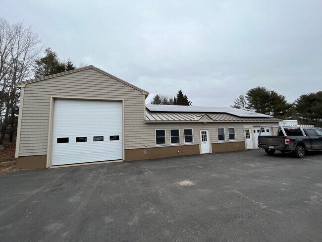
Property Detail
207 Augusta Rd
TOPM-000009-000000-000060-H000000-AR
Sagadahoc
Commercialofficeresidentialmixeduse
Maine
NO
60-h-a
A Areas with a 1% annual chance of flooding and a 26% chance of flooding over the life of a 30-year mortgage.
5.62 AC
2025
Sagadahoc County
2025
Portland/South Portland
970301
Portland-South Portland, ME
NEARBY LISTINGS FOR SALE OR LEASE
-
-
View all Topsham listings for lease on LoopNet.com
DEMOGRAPHICS near 207 Augusta Rd
1 mile
3 mile
5 mile
2025 Total Population
710
8,796
30,543
2030 Population
714
8,856
31,434
Pop Growth 2025-2030
+ 0.56%
+ 0.68%
+ 2.92%
Average Age
45
46
43
2025 Total Households
300
3,876
12,807
HH Growth 2025-2030
+ 0.67%
+ 0.72%
+ 2.91%
Median Household Inc
$95,535
$85,364
$80,596
Avg Household Size
2.30
2.20
2.20
2025 Avg HH Vehicles
2.00
2.00
2.00
Median Home Value
$363,690
$350,722
$363,505
Median Year Built
1997
1982
1982
Nearby Places
Map Layers
Map Styles
 Street
 Aerial
Layers
 Traffic
 Biking
Places
Listings with unknown addresses are not visible on the map
- Restaurants
- Banks
- Shops
- Fitness
- Groceries
PUBLIC TRANSPORTATION
COMMUTER RAIL
Brunswick Amtrak Station (Downeaster - Amtrak)
Drive
Walk
Distance
Brunswick Amtrak Station (Downeaster - Amtrak)
6 min
3.9 mi
AIRPORT
Portland International Jetport
Drive
Walk
Distance
Portland International Jetport
43 min
32.1 mi
Freight Ports
Portland, ME
Drive
Walk
Distance
Portland, ME
37 min
29.0 mi
SALE & LEASE HISTORY
LISTING DATE
SALE/LEASE

Sep 24, 2016
For Sale
Apr 13, 2022
For Lease
Nearby Properties
Address
Land Use
TOTAL SIZE
Lot Size
Zoning
Address
Land Use
TOTAL SIZE
Lot Size
Zoning
616.11 AC
NO
Address
Land Use
TOTAL SIZE
Lot Size
Zoning
Address
Land Use
TOTAL SIZE
Lot Size
Zoning
413,793 SF
4.94 AC
GM6
Address
Land Use
TOTAL SIZE
Lot Size
Zoning
199,222 SF
46.56 AC
NO
Address
Land Use
TOTAL SIZE
Lot Size
Zoning
30.78 AC
NO
Address
Land Use
TOTAL SIZE
Lot Size
Zoning
124,514 SF
10.76 AC
NO
Address
Land Use
TOTAL SIZE
Lot Size
Zoning
101,903 SF
7.25 AC
NO
Address
Land Use
TOTAL SIZE
Lot Size
Zoning
94,968 SF
16.88 AC
NO
Address
Land Use
TOTAL SIZE
Lot Size
Zoning
111,786 SF
4.20 AC
GM3
Address
Land Use
TOTAL SIZE
Lot Size
Zoning
78,120 SF
28.71 AC
NO
Address
Land Use
TOTAL SIZE
Lot Size
Zoning
86,743 SF
10.94 AC
NO
Address
Land Use
TOTAL SIZE
Lot Size
Zoning
60,772 SF
20.56 AC
NO
Address
Land Use
TOTAL SIZE
Lot Size
Zoning
5.14 AC
NO
Address
Land Use
TOTAL SIZE
Lot Size
Zoning
1.04 AC
NO
Address
Land Use
TOTAL SIZE
Lot Size
Zoning
46,303 SF
4.44 AC
NO
Address
Land Use
TOTAL SIZE
Lot Size
Zoning
64,339 SF
6.69 AC
NO
Address
Land Use
TOTAL SIZE
Lot Size
Zoning
2.40 AC
NO
Address
Land Use
TOTAL SIZE
Lot Size
Zoning
53.19 AC
NO
Address
Land Use
TOTAL SIZE
Lot Size
Zoning
28,311 SF
1.70 AC
GM3
Address
Land Use
TOTAL SIZE
Lot Size
Zoning
33,427 SF
2.91 AC
NO
Address
Land Use
TOTAL SIZE
Lot Size
Zoning
3.40 AC
NO
Address
Land Use
TOTAL SIZE
Lot Size
Zoning
6.22 AC
NO
Address
Land Use
TOTAL SIZE
Lot Size
Zoning
36,568 SF
9.41 AC
NO
Address
Land Use
TOTAL SIZE
Lot Size
Zoning
44,520 SF
5.40 AC
NO
Address
Land Use
TOTAL SIZE
Lot Size
Zoning
76,126 SF
4.92 AC
NO
Address
Land Use
TOTAL SIZE
Lot Size
Zoning
52,277 SF
10.23 AC
NO
Address
Land Use
TOTAL SIZE
Lot Size
Zoning
37,731 SF
0.43 AC
NO
Address
Land Use
TOTAL SIZE
Lot Size
Zoning
6.47 AC
NO
Address
Land Use
TOTAL SIZE
Lot Size
Zoning
54,334 SF
2.25 AC
NO
Address
Land Use
TOTAL SIZE
Lot Size
Zoning
25,399 SF
0.39 AC
NO
The World's #1 Commercial Real Estate Marketplace
Connect with us
© 2026 CoStar Group
The information above has been obtained from sources believed reliable. While we do not doubt its accuracy we have not verified it and make no guarantee, warranty or representation about it. It is your responsibility to independently confirm its accuracy and completeness. Any projections, opinions, assumptions, or estimates used are for example only and do not represent the current or future performance of the property. The value of this transaction to you depends on tax and other factors which should be evaluated by your tax, financial, and legal advisors. You and your advisors should conduct a careful, independent investigation of the property to determine to your satisfaction the suitability of the property for your needs.