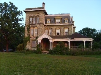
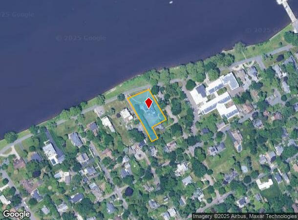
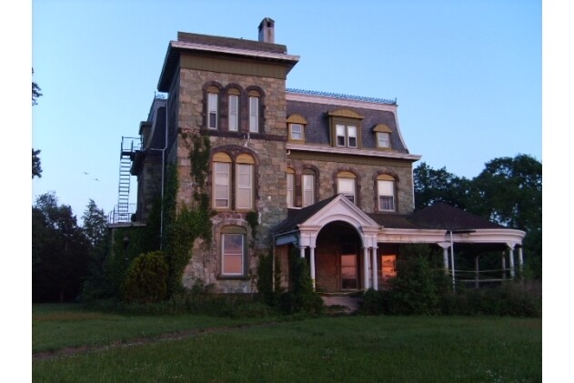
Property Record
207 Bank Ave, Riverton, NJ 08077

NEARBY LISTINGS FOR SALE OR LEASE
Property Detail
207 Bank Ave
31-00301-0000-00005
Burlington
Vacantlandnec
New Jersey
X
5
34005C0094F
1.14 AC
2024
Burlington County
2025
Philadelphia
700200
Philadelphia-Camden-Wilmington, PA-NJ-DE-MD
DEMOGRAPHICS near 207 Bank Ave
1 Mile
3 Mile
5 Mile
2024 Total Population
9,966
142,549
461,524
2029 Population
10,174
137,610
446,835
Pop Growth 2024-2029
+ 2.09%
(3.46%)
(3.18%)
Average Age
42
38
39
2024 Total Households
4,166
52,672
169,728
HH Growth 2024-2029
+ 1.85%
(3.52%)
(3.29%)
Median Household Inc
$92,249
$62,315
$60,205
Avg Household Size
2.30
2.60
2.60
2024 Avg HH Vehicles
2.00
1.00
1.00
Median Home Value
$222,316
$191,837
$208,003
Median Year Built
1957
1954
1955
Nearby Places
Map Layers
Map Styles
 Street
 Aerial
- Restaurants
- Banks
- Shops
- Fitness
- Groceries
PUBLIC TRANSPORTATION
TRANSIT/SUBWAY
Riverton (River LINE - River LINE (River LINE))
DRIVE
WALK
Distance
Riverton (River LINE - River LINE (River LINE))
2 min
14 min
0.7 mi
Palmyra (River LINE - River LINE (River LINE))
DRIVE
WALK
Distance
Palmyra (River LINE - River LINE (River LINE))
3 min
18 min
0.9 mi
COMMUTER RAIL
Tacony (R7 - Southeastern Pennsylvania Transportation Authority Regional Rail (SEPTA Regional Rail))
DRIVE
WALK
Distance
Tacony (R7 - Southeastern Pennsylvania Transportation Authority Regional Rail (SEPTA Regional Rail))
10 min
3.0 mi
Holmesburg Junction (R7 - Southeastern Pennsylvania Transportation Authority Regional Rail (SEPTA Regional Rail))
DRIVE
WALK
Distance
Holmesburg Junction (R7 - Southeastern Pennsylvania Transportation Authority Regional Rail (SEPTA Regional Rail))
12 min
4.1 mi
AIRPORT
Philadelphia International
DRIVE
WALK
Distance
Philadelphia International
36 min
20.8 mi
Trenton Mercer
DRIVE
WALK
Distance
Trenton Mercer
46 min
27.6 mi
Freight Ports
Port of Philadelphia
DRIVE
WALK
Distance
Port of Philadelphia
16 min
8.5 mi
Nearby Properties
Address
Land Use
TOTAL SIZE
Lot Size
Zoning
Address
Land Use
TOTAL SIZE
Lot Size
Zoning
740,701 SF
47.70 AC
I2
Address
Land Use
TOTAL SIZE
Lot Size
Zoning
597,188 SF
120.50 AC
RM2
Address
Land Use
TOTAL SIZE
Lot Size
Zoning
95,280 SF
117.33 AC
I3
Address
Land Use
TOTAL SIZE
Lot Size
Zoning
72.46 AC
Address
Land Use
TOTAL SIZE
Lot Size
Zoning
54.54 AC
Address
Land Use
TOTAL SIZE
Lot Size
Zoning
180,000 SF
23.05 AC
RSA1
Address
Land Use
TOTAL SIZE
Lot Size
Zoning
37.21 AC
SPPOA
Address
Land Use
TOTAL SIZE
Lot Size
Zoning
50.73 AC
C73A
Address
Land Use
TOTAL SIZE
Lot Size
Zoning
470,871 SF
41.87 AC
I3
Address
Land Use
TOTAL SIZE
Lot Size
Zoning
410,400 SF
34.14 AC
RSA1
Address
Land Use
TOTAL SIZE
Lot Size
Zoning
95.79 AC
Address
Land Use
TOTAL SIZE
Lot Size
Zoning
227,844 SF
19.82 AC
I2
Address
Land Use
TOTAL SIZE
Lot Size
Zoning
251,791 SF
15.59 AC
I2
Address
Land Use
TOTAL SIZE
Lot Size
Zoning
228,652 SF
12.81 AC
I1
Address
Land Use
TOTAL SIZE
Lot Size
Zoning
437,192 SF
28.03 AC
I2
Address
Land Use
TOTAL SIZE
Lot Size
Zoning
27.33 AC
Address
Land Use
TOTAL SIZE
Lot Size
Zoning
179,848 SF
12.87 AC
RSA1
Address
Land Use
TOTAL SIZE
Lot Size
Zoning
Address
Land Use
TOTAL SIZE
Lot Size
Zoning
82.32 AC
Address
Land Use
TOTAL SIZE
Lot Size
Zoning
1,681 SF
3 AC
ICMX
Address
Land Use
TOTAL SIZE
Lot Size
Zoning
3.59 AC
Address
Land Use
TOTAL SIZE
Lot Size
Zoning
121,194 SF
5.85 AC
RSA2
Address
Land Use
TOTAL SIZE
Lot Size
Zoning
8,197 SF
51.22 AC
I3
Address
Land Use
TOTAL SIZE
Lot Size
Zoning
39.53 AC
Address
Land Use
TOTAL SIZE
Lot Size
Zoning
19 AC
Address
Land Use
TOTAL SIZE
Lot Size
Zoning
148,609 SF
8.84 AC
ICMX
Address
Land Use
TOTAL SIZE
Lot Size
Zoning
150.59 AC
Address
Land Use
TOTAL SIZE
Lot Size
Zoning
109,445 SF
12.70 AC
ICMX
Address
Land Use
TOTAL SIZE
Lot Size
Zoning
115,573 SF
5.71 AC
CA1
Address
Land Use
TOTAL SIZE
Lot Size
Zoning
25.37 AC
The World's #1 Commercial Real Estate Marketplace
Connect with us
© 2025 CoStar Group
The information above has been obtained from sources believed reliable. While we do not doubt its accuracy we have not verified it and make no guarantee, warranty or representation about it. It is your responsibility to independently confirm its accuracy and completeness. Any projections, opinions, assumptions, or estimates used are for example only and do not represent the current or future performance of the property. The value of this transaction to you depends on tax and other factors which should be evaluated by your tax, financial, and legal advisors. You and your advisors should conduct a careful, independent investigation of the property to determine to your satisfaction the suitability of the property for your needs.