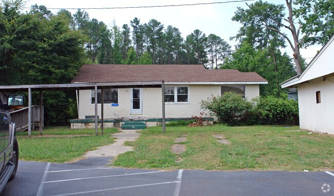
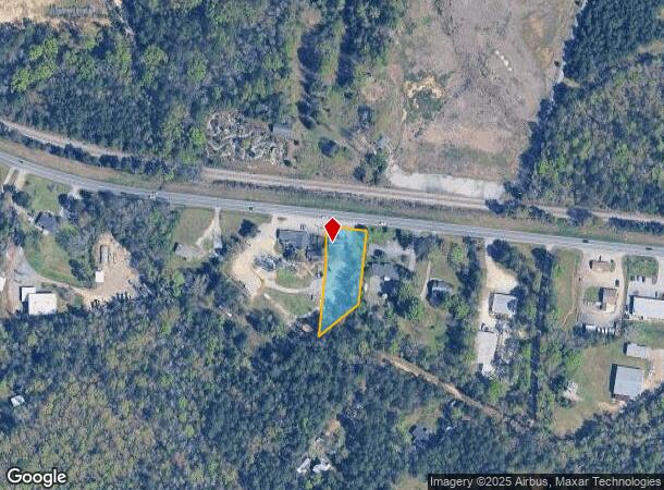
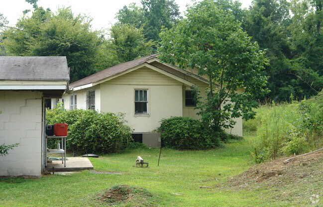
Property Record
207 Chapin Rd, Chapin, SC 29036
NEARBY LISTINGS FOR SALE OR LEASE
-
-
View all Chapin listings for sale on LoopNet.com
Property Detail
207 Chapin Rd
001200-01-045
LOT A
Commercialnec
Lexington
X
South Carolina
45063C0050J
a
2025
0.70 AC
2024
Dutch Fork/Irmo
021204
Columbia
1,920 SF
Columbia, SC
DEMOGRAPHICS near 207 Chapin Rd
1 mile
3 mile
5 mile
2024 Total Population
1,233
16,486
33,547
2029 Population
1,323
17,673
35,610
Pop Growth 2024-2029
+ 7.30%
+ 7.20%
+ 6.15%
Average Age
40
41
41
2024 Total Households
443
6,100
12,561
HH Growth 2024-2029
+ 7.22%
+ 7.31%
+ 6.34%
Median Household Inc
$86,944
$100,049
$105,257
Avg Household Size
2.60
2.60
2.60
2024 Avg HH Vehicles
2.00
2.00
2.00
Median Home Value
$270,702
$335,619
$333,303
Median Year Built
2003
2002
2002
Nearby Places
Map Layers
Map Styles
 Street
 Aerial
Transit
 Traffic
 Biking
Places
Listings with unknown addresses are not visible on the map
- Restaurants
- Banks
- Shops
- Fitness
- Groceries
PUBLIC TRANSPORTATION
AIRPORT
Columbia Metro
Drive
Walk
Distance
Columbia Metro
42 min
25.1 mi
Freight Ports
North Charleston Terminal
Drive
Walk
Distance
North Charleston Terminal
141 min
121.3 mi
Nearby Properties
Address
Land Use
TOTAL SIZE
Lot Size
Zoning
Address
Land Use
TOTAL SIZE
Lot Size
Zoning
31,005 SF
55.97 AC
PDD
Address
Land Use
TOTAL SIZE
Lot Size
Zoning
1,958 SF
145.19 AC
PDD
Address
Land Use
TOTAL SIZE
Lot Size
Zoning
57,020 SF
11.80 AC
PDD
Address
Land Use
TOTAL SIZE
Lot Size
Zoning
20,344 SF
13.21 AC
RU
Address
Land Use
TOTAL SIZE
Lot Size
Zoning
19,142 SF
15.08 AC
PDD
Address
Land Use
TOTAL SIZE
Lot Size
Zoning
5,050 SF
4.68 AC
RU
Address
Land Use
TOTAL SIZE
Lot Size
Zoning
4.20 AC
RU
Address
Land Use
TOTAL SIZE
Lot Size
Zoning
7,673 SF
1.03 AC
RS-LD
Address
Land Use
TOTAL SIZE
Lot Size
Zoning
16,034 SF
4.74 AC
RU
Address
Land Use
TOTAL SIZE
Lot Size
Zoning
10,764 SF
1.84 AC
GC
Address
Land Use
TOTAL SIZE
Lot Size
Zoning
7,464 SF
1.87 AC
RS-LD
Address
Land Use
TOTAL SIZE
Lot Size
Zoning
1,918 SF
0.80 AC
RU
Address
Land Use
TOTAL SIZE
Lot Size
Zoning
4,263 SF
0.99 AC
RS-LD
Address
Land Use
TOTAL SIZE
Lot Size
Zoning
6,837 SF
0.57 AC
RU
Address
Land Use
TOTAL SIZE
Lot Size
Zoning
3,189 SF
1.35 AC
RU
Address
Land Use
TOTAL SIZE
Lot Size
Zoning
5,138 SF
1.47 AC
RS-LD
Address
Land Use
TOTAL SIZE
Lot Size
Zoning
6,342 SF
0.83 AC
RU
Address
Land Use
TOTAL SIZE
Lot Size
Zoning
15,086 SF
4.85 AC
RU
Address
Land Use
TOTAL SIZE
Lot Size
Zoning
3,868 SF
0.88 AC
RU
Address
Land Use
TOTAL SIZE
Lot Size
Zoning
5,668 SF
3.52 AC
RS-LD
Address
Land Use
TOTAL SIZE
Lot Size
Zoning
4,802 SF
1.11 AC
RS-LD
Address
Land Use
TOTAL SIZE
Lot Size
Zoning
3,766 SF
0.68 AC
RS-LD
Address
Land Use
TOTAL SIZE
Lot Size
Zoning
4,602 SF
2.98 AC
RS-LD
Address
Land Use
TOTAL SIZE
Lot Size
Zoning
3,897 SF
0.55 AC
RS-LD
Address
Land Use
TOTAL SIZE
Lot Size
Zoning
7,000 SF
4.74 AC
RU
Address
Land Use
TOTAL SIZE
Lot Size
Zoning
7,806 SF
0.92 AC
RU
Address
Land Use
TOTAL SIZE
Lot Size
Zoning
4,151 SF
1.77 AC
RS-LD
Address
Land Use
TOTAL SIZE
Lot Size
Zoning
1,949 SF
0.49 AC
RS-LD
Address
Land Use
TOTAL SIZE
Lot Size
Zoning
4,644 SF
0.47 AC
PDD
Address
Land Use
TOTAL SIZE
Lot Size
Zoning
5,178 SF
1.27 AC
RS-LD
The World's #1 Commercial Real Estate Marketplace
Connect with us
© 2026 CoStar Group
The information above has been obtained from sources believed reliable. While we do not doubt its accuracy we have not verified it and make no guarantee, warranty or representation about it. It is your responsibility to independently confirm its accuracy and completeness. Any projections, opinions, assumptions, or estimates used are for example only and do not represent the current or future performance of the property. The value of this transaction to you depends on tax and other factors which should be evaluated by your tax, financial, and legal advisors. You and your advisors should conduct a careful, independent investigation of the property to determine to your satisfaction the suitability of the property for your needs.