Property Record
207 E Channel Rd, Benicia, CA 94510
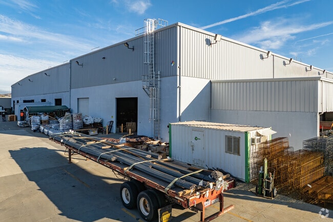

Property Detail
207 E Channel Rd
0080-250-220
BK-BG 00-00
Lightindustrial
Solano
AO River or stream flood hazard areas, and areas with a 1% or greater chance of shallow flooding each year. These areas have a 26% chance of flooding over the life of a 30-year mortgage.
California
2024
7.67 AC
2025
Benicia
252102
North Bay/Santa Rosa
77,841 SF
Vallejo, CA
NEARBY LISTINGS FOR SALE OR LEASE
DEMOGRAPHICS near 207 E Channel Rd
1 mile
3 mile
5 mile
2025 Total Population
1,188
26,696
73,390
2030 Population
1,193
26,841
73,844
Pop Growth 2025-2030
+ 0.42%
+ 0.54%
+ 0.62%
Average Age
41
44
44
2025 Total Households
393
10,776
28,215
HH Growth 2025-2030
+ 0.51%
+ 0.57%
+ 0.70%
Median Household Inc
$204,455
$130,904
$117,292
Avg Household Size
3.00
2.40
2.50
2025 Avg HH Vehicles
3.00
2.00
2.00
Median Home Value
$1,043,979
$775,175
$732,938
Median Year Built
1994
1980
1978
Nearby Places
Map Layers
Map Styles
 Street
 Aerial
Layers
 Traffic
 Biking
Places
Listings with unknown addresses are not visible on the map
- Restaurants
- Banks
- Shops
- Fitness
- Groceries
PUBLIC TRANSPORTATION
COMMUTER RAIL
Drive
Walk
Distance
11 min
5.9 mi
AIRPORT
Metro Oakland International
Drive
Walk
Distance
Metro Oakland International
52 min
37.3 mi
San Francisco International
Drive
Walk
Distance
San Francisco International
69 min
49.5 mi
Freight Ports
Port of Richmond
Drive
Walk
Distance
Port of Richmond
41 min
27.5 mi
Nearby Properties
Address
Land Use
TOTAL SIZE
Lot Size
Zoning
Address
Land Use
TOTAL SIZE
Lot Size
Zoning
324.69 AC
Address
Land Use
TOTAL SIZE
Lot Size
Zoning
19.90 AC
Address
Land Use
TOTAL SIZE
Lot Size
Zoning
160,000 SF
13.67 AC
Address
Land Use
TOTAL SIZE
Lot Size
Zoning
200,888 SF
19.11 AC
MR25
Address
Land Use
TOTAL SIZE
Lot Size
Zoning
55,805 SF
9.89 AC
Address
Land Use
TOTAL SIZE
Lot Size
Zoning
22,176 SF
15.14 AC
Address
Land Use
TOTAL SIZE
Lot Size
Zoning
220,527 SF
11.16 AC
INDUSTRIAL
Address
Land Use
TOTAL SIZE
Lot Size
Zoning
243,000 SF
12.62 AC
Address
Land Use
TOTAL SIZE
Lot Size
Zoning
86,222 SF
39.83 AC
Address
Land Use
TOTAL SIZE
Lot Size
Zoning
12.63 AC
Address
Land Use
TOTAL SIZE
Lot Size
Zoning
19.08 AC
Address
Land Use
TOTAL SIZE
Lot Size
Zoning
13.63 AC
Address
Land Use
TOTAL SIZE
Lot Size
Zoning
488,220 SF
11.88 AC
Address
Land Use
TOTAL SIZE
Lot Size
Zoning
240,000 SF
11.77 AC
Address
Land Use
TOTAL SIZE
Lot Size
Zoning
240,000 SF
9.60 AC
INDUSTRIAL
Address
Land Use
TOTAL SIZE
Lot Size
Zoning
12.80 AC
Address
Land Use
TOTAL SIZE
Lot Size
Zoning
158,987 SF
8.93 AC
Address
Land Use
TOTAL SIZE
Lot Size
Zoning
115,292 SF
9.85 AC
Address
Land Use
TOTAL SIZE
Lot Size
Zoning
100,547 SF
7.51 AC
Address
Land Use
TOTAL SIZE
Lot Size
Zoning
120,000 SF
5.52 AC
Address
Land Use
TOTAL SIZE
Lot Size
Zoning
1,536,263 SF
7.58 AC
Address
Land Use
TOTAL SIZE
Lot Size
Zoning
15,032 SF
47.47 AC
Address
Land Use
TOTAL SIZE
Lot Size
Zoning
63,160 SF
4.02 AC
GENMFG
Address
Land Use
TOTAL SIZE
Lot Size
Zoning
1,536,263 SF
6.57 AC
Address
Land Use
TOTAL SIZE
Lot Size
Zoning
142,020 SF
7.80 AC
Address
Land Use
TOTAL SIZE
Lot Size
Zoning
3.75 AC
RM
Address
Land Use
TOTAL SIZE
Lot Size
Zoning
1,536,263 SF
9.65 AC
Address
Land Use
TOTAL SIZE
Lot Size
Zoning
220,000 SF
9.33 AC
Address
Land Use
TOTAL SIZE
Lot Size
Zoning
1.81 AC
The World's #1 Commercial Real Estate Marketplace
Connect with us
© 2026 CoStar Group
The information above has been obtained from sources believed reliable. While we do not doubt its accuracy we have not verified it and make no guarantee, warranty or representation about it. It is your responsibility to independently confirm its accuracy and completeness. Any projections, opinions, assumptions, or estimates used are for example only and do not represent the current or future performance of the property. The value of this transaction to you depends on tax and other factors which should be evaluated by your tax, financial, and legal advisors. You and your advisors should conduct a careful, independent investigation of the property to determine to your satisfaction the suitability of the property for your needs.