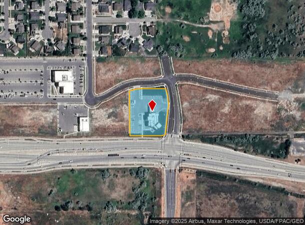
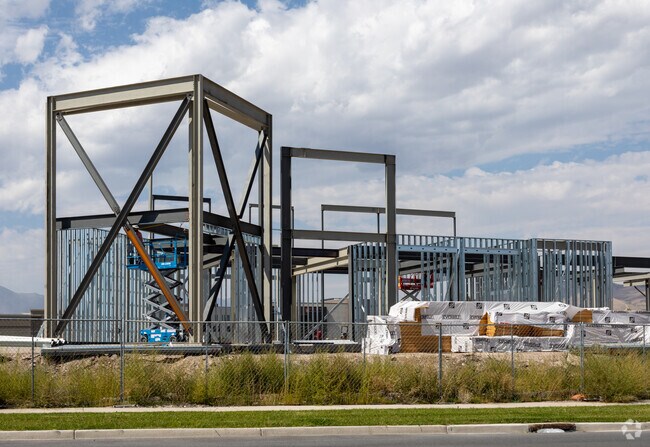
Property Record
207 E Thrive Dr, Saratoga Springs, UT 84045

NEARBY LISTINGS FOR SALE OR LEASE
Property Detail
207 E Thrive Dr
Provo-Orem, UT
PART LOT 9, PLAT A, RIVERSIDE CROSSING SUB DESCRIBED AS FOLLOWS; COM S 1063.98 FT & E 1221.69 FT FR N 1/4 COR. SEC. 23, T5S, R1W, SLB&M.; ALONG A CURVE TO R (CHORD BEARS: N 80 DEG 52 59 E 79.22 FT, RADIUS = 250 FT); E 41.53 FT; E 97.84 FT; S 12 DEG 3
51-682-0009
Utah
Financialbuilding
Utah
2024
9
2025
1.44 AC
010125
Utah County
10,372 SF
Salt Lake City
DEMOGRAPHICS near 207 E Thrive Dr
1 Mile
3 Mile
5 Mile
2024 Total Population
5,183
70,531
151,413
2029 Population
6,077
83,428
178,686
Pop Growth 2024-2029
+ 17.25%
+ 18.29%
+ 18.01%
Average Age
27
27
28
2024 Total Households
1,416
18,210
39,378
HH Growth 2024-2029
+ 17.66%
+ 18.90%
+ 18.50%
Median Household Inc
$95,763
$111,407
$110,298
Avg Household Size
3.70
3.90
3.80
2024 Avg HH Vehicles
2.00
2.00
2.00
Median Home Value
$481,090
$476,548
$480,819
Median Year Built
2010
2010
2010
Nearby Places
Map Layers
Map Styles
 Street
 Aerial
- Restaurants
- Banks
- Shops
- Fitness
- Groceries
PUBLIC TRANSPORTATION
COMMUTER RAIL
American Fork Station (FrontRunner - Utah Transit Authority (UTA))
DRIVE
WALK
Distance
American Fork Station (FrontRunner - Utah Transit Authority (UTA))
10 min
5.6 mi
Lehi Station (FrontRunner - Utah Transit Authority (UTA))
DRIVE
WALK
Distance
Lehi Station (FrontRunner - Utah Transit Authority (UTA))
11 min
6.1 mi
AIRPORT
Provo Municipal
DRIVE
WALK
Distance
Provo Municipal
29 min
21.1 mi
Salt Lake City International
DRIVE
WALK
Distance
Salt Lake City International
44 min
35.7 mi
Freight Ports
Port of Stockton
DRIVE
WALK
Distance
Port of Stockton
740 min
713.4 mi
Nearby Properties
Address
Land Use
TOTAL SIZE
Lot Size
Zoning
Address
Land Use
TOTAL SIZE
Lot Size
Zoning
36.17 AC
Address
Land Use
TOTAL SIZE
Lot Size
Zoning
293,170 SF
9.60 AC
Address
Land Use
TOTAL SIZE
Lot Size
Zoning
266,041 SF
11.28 AC
Address
Land Use
TOTAL SIZE
Lot Size
Zoning
61,537 SF
3 AC
Address
Land Use
TOTAL SIZE
Lot Size
Zoning
198,068 SF
20.72 AC
Address
Land Use
TOTAL SIZE
Lot Size
Zoning
123,381 SF
12.30 AC
Address
Land Use
TOTAL SIZE
Lot Size
Zoning
134,637 SF
16.98 AC
Address
Land Use
TOTAL SIZE
Lot Size
Zoning
99,862 SF
10.92 AC
Address
Land Use
TOTAL SIZE
Lot Size
Zoning
102,380 SF
9.10 AC
Address
Land Use
TOTAL SIZE
Lot Size
Zoning
64,605 SF
8.11 AC
Address
Land Use
TOTAL SIZE
Lot Size
Zoning
43,638 SF
40.32 AC
Address
Land Use
TOTAL SIZE
Lot Size
Zoning
90,049 SF
5.99 AC
Address
Land Use
TOTAL SIZE
Lot Size
Zoning
11,050 SF
19.23 AC
Address
Land Use
TOTAL SIZE
Lot Size
Zoning
120,431 SF
7.92 AC
Address
Land Use
TOTAL SIZE
Lot Size
Zoning
59,672 SF
3.24 AC
Address
Land Use
TOTAL SIZE
Lot Size
Zoning
96,361 SF
7.86 AC
Address
Land Use
TOTAL SIZE
Lot Size
Zoning
47,237 SF
4.14 AC
Address
Land Use
TOTAL SIZE
Lot Size
Zoning
87,141 SF
6.02 AC
Address
Land Use
TOTAL SIZE
Lot Size
Zoning
87,141 SF
5.24 AC
Address
Land Use
TOTAL SIZE
Lot Size
Zoning
58,277 SF
7.49 AC
Address
Land Use
TOTAL SIZE
Lot Size
Zoning
54,965 SF
9.42 AC
Address
Land Use
TOTAL SIZE
Lot Size
Zoning
119,128 SF
3.78 AC
Address
Land Use
TOTAL SIZE
Lot Size
Zoning
14.70 AC
Address
Land Use
TOTAL SIZE
Lot Size
Zoning
56,652 SF
5.66 AC
Address
Land Use
TOTAL SIZE
Lot Size
Zoning
36,089 SF
4.29 AC
Address
Land Use
TOTAL SIZE
Lot Size
Zoning
126,442 SF
7.06 AC
Address
Land Use
TOTAL SIZE
Lot Size
Zoning
31,314 SF
1.77 AC
Address
Land Use
TOTAL SIZE
Lot Size
Zoning
117,669 SF
3.47 AC
Address
Land Use
TOTAL SIZE
Lot Size
Zoning
55,229 SF
4.61 AC
The World's #1 Commercial Real Estate Marketplace
Connect with us
© 2025 CoStar Group
The information above has been obtained from sources believed reliable. While we do not doubt its accuracy we have not verified it and make no guarantee, warranty or representation about it. It is your responsibility to independently confirm its accuracy and completeness. Any projections, opinions, assumptions, or estimates used are for example only and do not represent the current or future performance of the property. The value of this transaction to you depends on tax and other factors which should be evaluated by your tax, financial, and legal advisors. You and your advisors should conduct a careful, independent investigation of the property to determine to your satisfaction the suitability of the property for your needs.