No Photo
Property Record
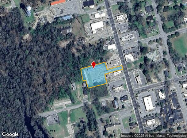
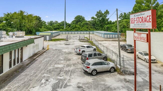
N Longstreet St, Kingstree, SC 29556

NEARBY LISTINGS FOR SALE OR LEASE
-
-
View all Kingstree listings for sale on LoopNet.com
Property Detail
N Longstreet St
Commercialnec
W LONGSTREET ST
X
Williamsburg
45089C0262E
South Carolina
2024
1.40 AC
2024
South Carolina Rural Areas
970502
Other Market Areas
4,500 SF
11-025-020
DEMOGRAPHICS near N Longstreet St
1 Mile
3 Mile
5 Mile
2024 Total Population
2,468
6,853
9,588
2029 Population
2,383
6,645
9,298
Pop Growth 2024-2029
(3.44%)
(3.04%)
(3.02%)
Average Age
42
42
42
2024 Total Households
1,055
2,875
4,046
HH Growth 2024-2029
(3.13%)
(2.78%)
(2.79%)
Median Household Inc
$33,749
$39,059
$41,335
Avg Household Size
2.20
2.30
2.30
2024 Avg HH Vehicles
1.00
1.00
2.00
Median Home Value
$103,509
$84,645
$79,118
Median Year Built
1975
1980
1981
Nearby Places
Map Layers
Map Styles
 Street
 Aerial
- Restaurants
- Banks
- Shops
- Fitness
- Groceries
PUBLIC TRANSPORTATION
COMMUTER RAIL
Kingstree Amtrak Station (Palmetto - Amtrak, Silver Meteor - Amtrak)
DRIVE
WALK
Distance
Kingstree Amtrak Station (Palmetto - Amtrak, Silver Meteor - Amtrak)
1 min
8 min
0.4 mi
Freight Ports
North Charleston Terminal
DRIVE
WALK
Distance
North Charleston Terminal
83 min
64.1 mi
SALE & LEASE HISTORY
LISTING DATE
SALE/LEASE

Sep 26, 2022
For Sale
Oct 13, 2022
For Sale
Oct 07, 2022
For Sale
Oct 06, 2022
For Sale
Dec 20, 2022
For Sale
Nearby Properties
Address
Land Use
TOTAL SIZE
Lot Size
Zoning
Address
Land Use
TOTAL SIZE
Lot Size
Zoning
Address
Land Use
TOTAL SIZE
Lot Size
Zoning
Address
Land Use
TOTAL SIZE
Lot Size
Zoning
Address
Land Use
TOTAL SIZE
Lot Size
Zoning
193.86 AC
Address
Land Use
TOTAL SIZE
Lot Size
Zoning
Address
Land Use
TOTAL SIZE
Lot Size
Zoning
7,056 SF
Address
Land Use
TOTAL SIZE
Lot Size
Zoning
43.50 AC
Address
Land Use
TOTAL SIZE
Lot Size
Zoning
54.66 AC
Address
Land Use
TOTAL SIZE
Lot Size
Zoning
Address
Land Use
TOTAL SIZE
Lot Size
Zoning
6,216 SF
Address
Land Use
TOTAL SIZE
Lot Size
Zoning
19,016 SF
Address
Land Use
TOTAL SIZE
Lot Size
Zoning
2,368 SF
0.06 AC
Address
Land Use
TOTAL SIZE
Lot Size
Zoning
Address
Land Use
TOTAL SIZE
Lot Size
Zoning
Address
Land Use
TOTAL SIZE
Lot Size
Zoning
Address
Land Use
TOTAL SIZE
Lot Size
Zoning
3.60 AC
Address
Land Use
TOTAL SIZE
Lot Size
Zoning
Address
Land Use
TOTAL SIZE
Lot Size
Zoning
15.74 AC
Address
Land Use
TOTAL SIZE
Lot Size
Zoning
20,670 SF
Address
Land Use
TOTAL SIZE
Lot Size
Zoning
Address
Land Use
TOTAL SIZE
Lot Size
Zoning
Address
Land Use
TOTAL SIZE
Lot Size
Zoning
Address
Land Use
TOTAL SIZE
Lot Size
Zoning
4,004 SF
3.90 AC
Address
Land Use
TOTAL SIZE
Lot Size
Zoning
Address
Land Use
TOTAL SIZE
Lot Size
Zoning
Address
Land Use
TOTAL SIZE
Lot Size
Zoning
18,780 SF
1.21 AC
Address
Land Use
TOTAL SIZE
Lot Size
Zoning
2.10 AC
Address
Land Use
TOTAL SIZE
Lot Size
Zoning
Address
Land Use
TOTAL SIZE
Lot Size
Zoning
3,900 SF
4.20 AC
Address
Land Use
TOTAL SIZE
Lot Size
Zoning
The World's #1 Commercial Real Estate Marketplace
Connect with us
© 2025 CoStar Group
The information above has been obtained from sources believed reliable. While we do not doubt its accuracy we have not verified it and make no guarantee, warranty or representation about it. It is your responsibility to independently confirm its accuracy and completeness. Any projections, opinions, assumptions, or estimates used are for example only and do not represent the current or future performance of the property. The value of this transaction to you depends on tax and other factors which should be evaluated by your tax, financial, and legal advisors. You and your advisors should conduct a careful, independent investigation of the property to determine to your satisfaction the suitability of the property for your needs.