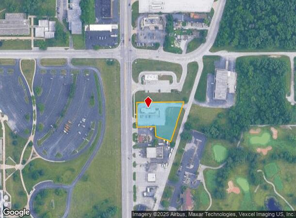
Property Record
201 S Halsted St, Chicago Heights, IL 60411
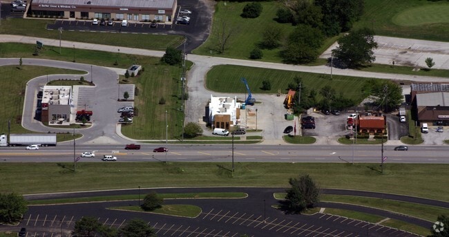

This Property Is For Sale
Current Lease Availabilities
NEARBY LISTINGS FOR SALE OR LEASE
Property Detail
201 S Halsted St
32-16-102-020-0000
Percy Wilsons Eastgate Add/Ar
Commercialbuilding
Cook
X
Illinois
17031C0744J
1,2
2023
1.12 AC
2024
Far South
828900
Chicago
2,565 SF
Chicago-Naperville-Elgin, IL-IN-WI
DEMOGRAPHICS near 201 S Halsted St
1 Mile
3 Mile
5 Mile
2024 Total Population
8,310
68,375
189,162
2029 Population
8,084
67,168
185,633
Pop Growth 2024-2029
(2.72%)
(1.77%)
(1.87%)
Average Age
39
40
40
2024 Total Households
2,844
24,152
69,549
HH Growth 2024-2029
(2.95%)
(2.13%)
(2.19%)
Median Household Inc
$71,171
$67,262
$62,890
Avg Household Size
2.80
2.70
2.60
2024 Avg HH Vehicles
2.00
2.00
2.00
Median Home Value
$144,435
$160,814
$149,832
Median Year Built
1958
1962
1966
Nearby Places
- Restaurants
- Banks
- Shops
- Fitness
- Groceries
PUBLIC TRANSPORTATION
COMMUTER RAIL
Flossmoor Station (Metra Electric Line - Northeast Illinois Regional Commuter Railroad (Metra))
DRIVE
WALK
Distance
Flossmoor Station (Metra Electric Line - Northeast Illinois Regional Commuter Railroad (Metra))
8 min
3.2 mi
Olympia Fields Station (Metra Electric Line - Northeast Illinois Regional Commuter Railroad (Metra))
DRIVE
WALK
Distance
Olympia Fields Station (Metra Electric Line - Northeast Illinois Regional Commuter Railroad (Metra))
9 min
3.6 mi
AIRPORT
Chicago Midway International
DRIVE
WALK
Distance
Chicago Midway International
37 min
22.9 mi
Chicago O'Hare International
DRIVE
WALK
Distance
Chicago O'Hare International
62 min
44.6 mi
Nearby Properties
Address
Land Use
TOTAL SIZE
Lot Size
Zoning
Address
Land Use
TOTAL SIZE
Lot Size
Zoning
Address
Land Use
TOTAL SIZE
Lot Size
Zoning
244,665 SF
9.05 AC
Address
Land Use
TOTAL SIZE
Lot Size
Zoning
Address
Land Use
TOTAL SIZE
Lot Size
Zoning
31,952 SF
4.03 AC
Address
Land Use
TOTAL SIZE
Lot Size
Zoning
78,884 SF
5.60 AC
Address
Land Use
TOTAL SIZE
Lot Size
Zoning
304,256 SF
21.50 AC
Address
Land Use
TOTAL SIZE
Lot Size
Zoning
2,845,012 SF
133.73 AC
Address
Land Use
TOTAL SIZE
Lot Size
Zoning
196,125 SF
18.55 AC
Address
Land Use
TOTAL SIZE
Lot Size
Zoning
Address
Land Use
TOTAL SIZE
Lot Size
Zoning
44,274 SF
3 AC
Address
Land Use
TOTAL SIZE
Lot Size
Zoning
183,041 SF
18.71 AC
Address
Land Use
TOTAL SIZE
Lot Size
Zoning
52,220 SF
6 AC
Address
Land Use
TOTAL SIZE
Lot Size
Zoning
125,535 SF
9.44 AC
Address
Land Use
TOTAL SIZE
Lot Size
Zoning
37,309 SF
1.50 AC
Address
Land Use
TOTAL SIZE
Lot Size
Zoning
182,300 SF
144.71 AC
Address
Land Use
TOTAL SIZE
Lot Size
Zoning
115,250 SF
10.75 AC
Address
Land Use
TOTAL SIZE
Lot Size
Zoning
189,489 SF
20 AC
Address
Land Use
TOTAL SIZE
Lot Size
Zoning
562,369 SF
50 AC
Address
Land Use
TOTAL SIZE
Lot Size
Zoning
111,902 SF
8.60 AC
Address
Land Use
TOTAL SIZE
Lot Size
Zoning
284,100 SF
12.60 AC
Address
Land Use
TOTAL SIZE
Lot Size
Zoning
44,000 SF
1.44 AC
Address
Land Use
TOTAL SIZE
Lot Size
Zoning
24,508 SF
1.13 AC
Address
Land Use
TOTAL SIZE
Lot Size
Zoning
6.21 AC
Address
Land Use
TOTAL SIZE
Lot Size
Zoning
0.34 AC
Address
Land Use
TOTAL SIZE
Lot Size
Zoning
139,936 SF
73.19 AC
Address
Land Use
TOTAL SIZE
Lot Size
Zoning
Address
Land Use
TOTAL SIZE
Lot Size
Zoning
Address
Land Use
TOTAL SIZE
Lot Size
Zoning
45,869 SF
203.14 AC
Address
Land Use
TOTAL SIZE
Lot Size
Zoning
Address
Land Use
TOTAL SIZE
Lot Size
Zoning
105,001 SF
5.77 AC
The World's #1 Commercial Real Estate Marketplace
Connect with us
© 2025 CoStar Group
The information above has been obtained from sources believed reliable. While we do not doubt its accuracy we have not verified it and make no guarantee, warranty or representation about it. It is your responsibility to independently confirm its accuracy and completeness. Any projections, opinions, assumptions, or estimates used are for example only and do not represent the current or future performance of the property. The value of this transaction to you depends on tax and other factors which should be evaluated by your tax, financial, and legal advisors. You and your advisors should conduct a careful, independent investigation of the property to determine to your satisfaction the suitability of the property for your needs.