No Photo
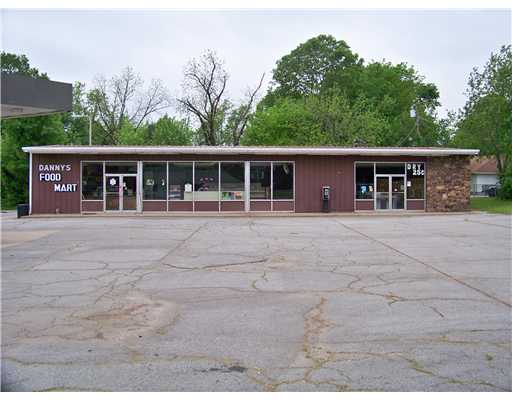
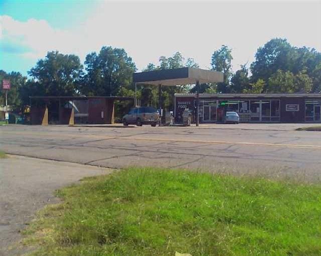
Property Record
207 W Highway 64 E, Mulberry, AR 72947

Save to a Folder
{{folder.Name}}
{{folder.ListingIds.length}} Properties
{{folder.ListingIds.length}} Property
Create a New Folder
Property Detail
207 W Highway 64 E
Fort Smith, AR-OK
PER DOC# 2007010054 FILED ON 8/6/2007 PART OF LOTS 1, 6 AND 7, BLOCK 4, BRYANT'S ADDITION TO MULBERRY, CRAWFORD COUNTY, ARKAN
760-00271-001-C
CRAWFORD
Clubslodgesprofessionalassociations
Arkansas
B and X Area of moderate flood hazard, usually the area between the limits of the 100-year and 500-year floods.
1,6
2025
0.48 AC
2025
Crawford County
020402
Fort Smith
3,360 SF
NEARBY LISTINGS FOR SALE OR LEASE
-
-
View all Mulberry listings for sale on LoopNet.com
DEMOGRAPHICS near 207 W Highway 64 E
1 mile
3 mile
5 mile
2025 Total Population
1,498
2,251
3,784
2030 Population
1,594
2,379
3,953
Pop Growth 2025-2030
+ 6.41%
+ 5.69%
+ 4.47%
Average Age
42
42
43
2025 Total Households
590
889
1,491
HH Growth 2025-2030
+ 6.27%
+ 5.62%
+ 4.49%
Median Household Inc
$51,500
$53,466
$55,722
Avg Household Size
2.40
2.40
2.50
2025 Avg HH Vehicles
2.00
2.00
2.00
Median Home Value
$144,178
$149,052
$160,090
Median Year Built
1973
1974
1978
Nearby Places
Map Layers
Map Styles
 Street
 Aerial
Layers
 Traffic
 Biking
Places
Listings with unknown addresses are not visible on the map
- Restaurants
- Banks
- Shops
- Fitness
- Groceries
PUBLIC TRANSPORTATION
AIRPORT
Fort Smith Regional
Drive
Walk
Distance
Fort Smith Regional
38 min
27.1 mi
Nearby Properties
Address
Land Use
TOTAL SIZE
Lot Size
Zoning
Address
Land Use
TOTAL SIZE
Lot Size
Zoning
142,160 SF
40 AC
Address
Land Use
TOTAL SIZE
Lot Size
Zoning
58,520 SF
9.76 AC
Address
Land Use
TOTAL SIZE
Lot Size
Zoning
57,000 SF
20 AC
Address
Land Use
TOTAL SIZE
Lot Size
Zoning
8,625 SF
1.06 AC
Address
Land Use
TOTAL SIZE
Lot Size
Zoning
6,232 SF
0.70 AC
Address
Land Use
TOTAL SIZE
Lot Size
Zoning
14,793 SF
1.40 AC
Address
Land Use
TOTAL SIZE
Lot Size
Zoning
33,492 SF
3.67 AC
Address
Land Use
TOTAL SIZE
Lot Size
Zoning
7,425 SF
20 AC
Address
Land Use
TOTAL SIZE
Lot Size
Zoning
33,160 SF
2 AC
Address
Land Use
TOTAL SIZE
Lot Size
Zoning
17,796 SF
3.52 AC
Address
Land Use
TOTAL SIZE
Lot Size
Zoning
10,814 SF
1.60 AC
Address
Land Use
TOTAL SIZE
Lot Size
Zoning
9,708 SF
0.26 AC
Address
Land Use
TOTAL SIZE
Lot Size
Zoning
6,800 SF
4 AC
Address
Land Use
TOTAL SIZE
Lot Size
Zoning
8,906 SF
5.64 AC
Address
Land Use
TOTAL SIZE
Lot Size
Zoning
7,948 SF
10 AC
Address
Land Use
TOTAL SIZE
Lot Size
Zoning
792 SF
23.45 AC
Address
Land Use
TOTAL SIZE
Lot Size
Zoning
10,000 SF
2 AC
Address
Land Use
TOTAL SIZE
Lot Size
Zoning
2,880 SF
5.47 AC
Address
Land Use
TOTAL SIZE
Lot Size
Zoning
12,906 SF
1.48 AC
Address
Land Use
TOTAL SIZE
Lot Size
Zoning
15,675 SF
2.09 AC
Address
Land Use
TOTAL SIZE
Lot Size
Zoning
3,470 SF
0.39 AC
Address
Land Use
TOTAL SIZE
Lot Size
Zoning
2,004 SF
1.20 AC
Address
Land Use
TOTAL SIZE
Lot Size
Zoning
11,500 SF
4.18 AC
Address
Land Use
TOTAL SIZE
Lot Size
Zoning
8,800 SF
16.06 AC
Address
Land Use
TOTAL SIZE
Lot Size
Zoning
9,524 SF
1 AC
Address
Land Use
TOTAL SIZE
Lot Size
Zoning
4,664 SF
0.54 AC
Address
Land Use
TOTAL SIZE
Lot Size
Zoning
7,451 SF
3.02 AC
Address
Land Use
TOTAL SIZE
Lot Size
Zoning
12,095 SF
79.76 AC
Address
Land Use
TOTAL SIZE
Lot Size
Zoning
2,014 SF
0.30 AC
The World's #1 Commercial Real Estate Marketplace
Connect with us
© 2026 CoStar Group
The information above has been obtained from sources believed reliable. While we do not doubt its accuracy we have not verified it and make no guarantee, warranty or representation about it. It is your responsibility to independently confirm its accuracy and completeness. Any projections, opinions, assumptions, or estimates used are for example only and do not represent the current or future performance of the property. The value of this transaction to you depends on tax and other factors which should be evaluated by your tax, financial, and legal advisors. You and your advisors should conduct a careful, independent investigation of the property to determine to your satisfaction the suitability of the property for your needs.