Property Record
207 W Main St, Mayodan, NC 27027
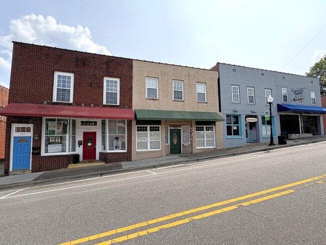


This Property Is For Sale
Property Detail
207 W Main St
120274
MAIN ST 50 FF H R MARTIN ESTATE
Storebuilding
ROCKINGHAM
CENTRAL CO
North Carolina
B and X Area of moderate flood hazard, usually the area between the limits of the 100-year and 500-year floods.
0.13 AC
2025
Rockingham County
2025
Greensboro/Winston-Salem
040900
Greensboro-High Point, NC
3,946 SF
NEARBY LISTINGS FOR SALE OR LEASE
DEMOGRAPHICS near 207 W Main St
1 mile
3 mile
5 mile
2025 Total Population
2,842
7,047
12,674
2030 Population
2,896
7,213
12,999
Pop Growth 2025-2030
+ 1.90%
+ 2.36%
+ 2.56%
Average Age
45
45
45
2025 Total Households
1,370
3,270
5,566
HH Growth 2025-2030
+ 1.82%
+ 2.32%
+ 2.55%
Median Household Inc
$53,109
$53,658
$55,933
Avg Household Size
2.10
2.10
2.20
2025 Avg HH Vehicles
2.00
2.00
2.00
Median Home Value
$146,587
$151,428
$160,757
Median Year Built
1968
1972
1977
Nearby Places
Map Layers
Map Styles
 Street
 Aerial
Layers
 Traffic
 Biking
Places
Listings with unknown addresses are not visible on the map
- Restaurants
- Banks
- Shops
- Fitness
- Groceries
PUBLIC TRANSPORTATION
AIRPORT
Piedmont Triad International
Drive
Walk
Distance
Piedmont Triad International
36 min
25.9 mi
Nearby Properties
Address
Land Use
TOTAL SIZE
Lot Size
Zoning
Address
Land Use
TOTAL SIZE
Lot Size
Zoning
941,000 SF
94.83 AC
HEAVY MANU
Address
Land Use
TOTAL SIZE
Lot Size
Zoning
156,633 SF
166.50 AC
RES AG COU
Address
Land Use
TOTAL SIZE
Lot Size
Zoning
78,062 SF
50 AC
RES 8 MADI
Address
Land Use
TOTAL SIZE
Lot Size
Zoning
656,287 SF
40.56 AC
HEAVY IND
Address
Land Use
TOTAL SIZE
Lot Size
Zoning
158,722 SF
18.86 AC
HWY BUS MA
Address
Land Use
TOTAL SIZE
Lot Size
Zoning
428,472 SF
20.32 AC
INDUSTRIAL
Address
Land Use
TOTAL SIZE
Lot Size
Zoning
163,701 SF
15.25 AC
INDUSTRIAL
Address
Land Use
TOTAL SIZE
Lot Size
Zoning
110,935 SF
12.45 AC
HWY BUS MA
Address
Land Use
TOTAL SIZE
Lot Size
Zoning
191,752 SF
53.36 AC
INDUSTRIAL
Address
Land Use
TOTAL SIZE
Lot Size
Zoning
147,024 SF
10.03 AC
HEAVY IND
Address
Land Use
TOTAL SIZE
Lot Size
Zoning
62,938 SF
5.52 AC
HWY BUS MA
Address
Land Use
TOTAL SIZE
Lot Size
Zoning
41,831 SF
12.88 AC
HWY BUS MA
Address
Land Use
TOTAL SIZE
Lot Size
Zoning
225,514 SF
16.09 AC
INDUSTRIAL
Address
Land Use
TOTAL SIZE
Lot Size
Zoning
36,766 SF
18.21 AC
RES 8 MADI
Address
Land Use
TOTAL SIZE
Lot Size
Zoning
43,168 SF
13.68 AC
HEAVY IND
Address
Land Use
TOTAL SIZE
Lot Size
Zoning
79,940 SF
16.67 AC
GENERAL CO
Address
Land Use
TOTAL SIZE
Lot Size
Zoning
313,466 SF
16.45 AC
INDUSTRIAL
Address
Land Use
TOTAL SIZE
Lot Size
Zoning
91,059 SF
9.55 AC
GENERAL CO
Address
Land Use
TOTAL SIZE
Lot Size
Zoning
16,539 SF
0.40 AC
RES 6 MAYO
Address
Land Use
TOTAL SIZE
Lot Size
Zoning
38,694 SF
5.10 AC
GENERAL CO
Address
Land Use
TOTAL SIZE
Lot Size
Zoning
18,854 SF
3.19 AC
RES 20 MAY
Address
Land Use
TOTAL SIZE
Lot Size
Zoning
44,160 SF
4.98 AC
INDUSTRIAL
Address
Land Use
TOTAL SIZE
Lot Size
Zoning
129,132 SF
22.70 AC
HEAVY MANU
Address
Land Use
TOTAL SIZE
Lot Size
Zoning
3,028 SF
14.40 AC
RES 8 MADI
Address
Land Use
TOTAL SIZE
Lot Size
Zoning
183,868 SF
12.80 AC
INDUSTRIAL
Address
Land Use
TOTAL SIZE
Lot Size
Zoning
38,016 SF
TOWN CENTE
Address
Land Use
TOTAL SIZE
Lot Size
Zoning
11,544 SF
4.67 AC
GENERAL CO
Address
Land Use
TOTAL SIZE
Lot Size
Zoning
4,512 SF
6.90 AC
RES 6 MAYO
Address
Land Use
TOTAL SIZE
Lot Size
Zoning
101,890 SF
8.54 AC
MANUFACTUR
Address
Land Use
TOTAL SIZE
Lot Size
Zoning
106,000 SF
23.84 AC
HEAVY MANU
The World's #1 Commercial Real Estate Marketplace
Connect with us
© 2026 CoStar Group
The information above has been obtained from sources believed reliable. While we do not doubt its accuracy we have not verified it and make no guarantee, warranty or representation about it. It is your responsibility to independently confirm its accuracy and completeness. Any projections, opinions, assumptions, or estimates used are for example only and do not represent the current or future performance of the property. The value of this transaction to you depends on tax and other factors which should be evaluated by your tax, financial, and legal advisors. You and your advisors should conduct a careful, independent investigation of the property to determine to your satisfaction the suitability of the property for your needs.