Property Record
207 Webster Square Rd, Berlin, CT 06037
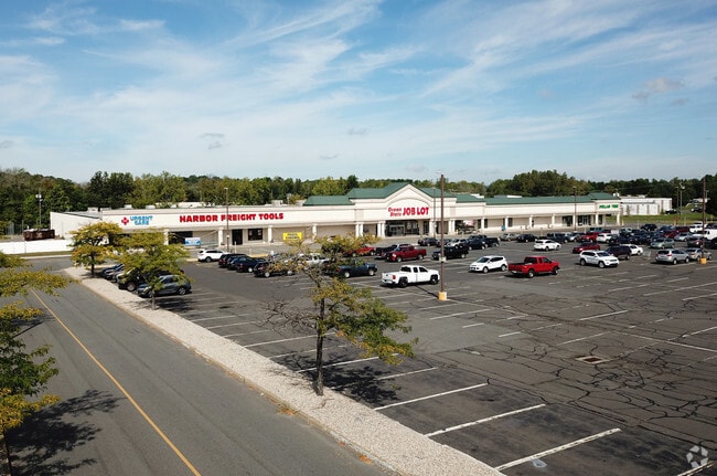

Property Detail
207 Webster Square Rd
BERL-000103-000083-000028-000001B
HARTFORD
Supermarket
Connecticut
PS-A
28-1b
AE The base floodplain where base flood elevations are provided. AE Zones are now used on new format FIRMs instead of A1-A30 Zones.
5.07 AC
2025
Berlin Outlying
2025
Hartford
400101
Hartford-West Hartford-East Hartford, CT
62,669 SF
NEARBY LISTINGS FOR SALE OR LEASE
DEMOGRAPHICS near 207 Webster Square Rd
1 mile
3 mile
5 mile
2025 Total Population
2,417
48,000
145,134
2030 Population
2,460
48,343
146,691
Pop Growth 2025-2030
+ 1.78%
+ 0.71%
+ 1.07%
Average Age
46
41
41
2025 Total Households
1,065
19,196
58,852
HH Growth 2025-2030
+ 1.88%
+ 0.78%
+ 1.11%
Median Household Inc
$83,817
$82,786
$80,743
Avg Household Size
2.30
2.40
2.40
2025 Avg HH Vehicles
2.00
2.00
2.00
Median Home Value
$343,500
$333,360
$313,202
Median Year Built
1971
1966
1967
Nearby Places
Map Layers
Map Styles
 Street
 Aerial
Transit
 Traffic
 Biking
Places
Listings with unknown addresses are not visible on the map
- Restaurants
- Banks
- Shops
- Fitness
- Groceries
PUBLIC TRANSPORTATION
AIRPORT
Bradley International
Drive
Walk
Distance
Bradley International
34 min
25.3 mi
Freight Ports
Port of Davisville, RI
Drive
Walk
Distance
Port of Davisville, RI
1 min
69.0 mi
SALE & LEASE HISTORY
LISTING DATE
SALE/LEASE

Mar 09, 2017
For Lease
Nearby Properties
Address
Land Use
TOTAL SIZE
Lot Size
Zoning
Address
Land Use
TOTAL SIZE
Lot Size
Zoning
109,079 SF
110.62 AC
OT
Address
Land Use
TOTAL SIZE
Lot Size
Zoning
241,225 SF
25.64 AC
R-11
Address
Land Use
TOTAL SIZE
Lot Size
Zoning
96,238 SF
6.75 AC
T
Address
Land Use
TOTAL SIZE
Lot Size
Zoning
13.34 AC
PD
Address
Land Use
TOTAL SIZE
Lot Size
Zoning
33.36 AC
T
Address
Land Use
TOTAL SIZE
Lot Size
Zoning
78,109 SF
8.22 AC
T
Address
Land Use
TOTAL SIZE
Lot Size
Zoning
21.35 AC
PD
Address
Land Use
TOTAL SIZE
Lot Size
Zoning
68 AC
R-20
Address
Land Use
TOTAL SIZE
Lot Size
Zoning
18.40 AC
PD
Address
Land Use
TOTAL SIZE
Lot Size
Zoning
74,670 SF
4.46 AC
S2
Address
Land Use
TOTAL SIZE
Lot Size
Zoning
129,626 SF
22.36 AC
IT
Address
Land Use
TOTAL SIZE
Lot Size
Zoning
5.20 AC
PD
Address
Land Use
TOTAL SIZE
Lot Size
Zoning
38,860 SF
38.47 AC
PS-B
Address
Land Use
TOTAL SIZE
Lot Size
Zoning
83,464 SF
13.96 AC
T
Address
Land Use
TOTAL SIZE
Lot Size
Zoning
185,902 SF
101.89 AC
GI-2
Address
Land Use
TOTAL SIZE
Lot Size
Zoning
16.29 AC
PD
Address
Land Use
TOTAL SIZE
Lot Size
Zoning
76,510 SF
10 AC
R-11
Address
Land Use
TOTAL SIZE
Lot Size
Zoning
18.53 AC
BTD
Address
Land Use
TOTAL SIZE
Lot Size
Zoning
91,663 SF
22.20 AC
R-21
Address
Land Use
TOTAL SIZE
Lot Size
Zoning
10.76 AC
PD
Address
Land Use
TOTAL SIZE
Lot Size
Zoning
44,084 SF
1.36 AC
T
Address
Land Use
TOTAL SIZE
Lot Size
Zoning
5.03 AC
OP
Address
Land Use
TOTAL SIZE
Lot Size
Zoning
25.10 AC
R-15
Address
Land Use
TOTAL SIZE
Lot Size
Zoning
5.65 AC
HB
Address
Land Use
TOTAL SIZE
Lot Size
Zoning
125,492 SF
12.39 AC
PD
Address
Land Use
TOTAL SIZE
Lot Size
Zoning
133,290 SF
11.64 AC
PD
Address
Land Use
TOTAL SIZE
Lot Size
Zoning
133,946 SF
18.32 AC
PD
Address
Land Use
TOTAL SIZE
Lot Size
Zoning
13.02 AC
HB
Address
Land Use
TOTAL SIZE
Lot Size
Zoning
67,050 SF
20.36 AC
R-15
Address
Land Use
TOTAL SIZE
Lot Size
Zoning
61,435 SF
25.96 AC
R-15
The World's #1 Commercial Real Estate Marketplace
Connect with us
© 2026 CoStar Group
The information above has been obtained from sources believed reliable. While we do not doubt its accuracy we have not verified it and make no guarantee, warranty or representation about it. It is your responsibility to independently confirm its accuracy and completeness. Any projections, opinions, assumptions, or estimates used are for example only and do not represent the current or future performance of the property. The value of this transaction to you depends on tax and other factors which should be evaluated by your tax, financial, and legal advisors. You and your advisors should conduct a careful, independent investigation of the property to determine to your satisfaction the suitability of the property for your needs.