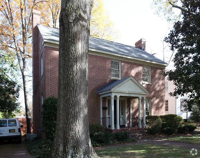
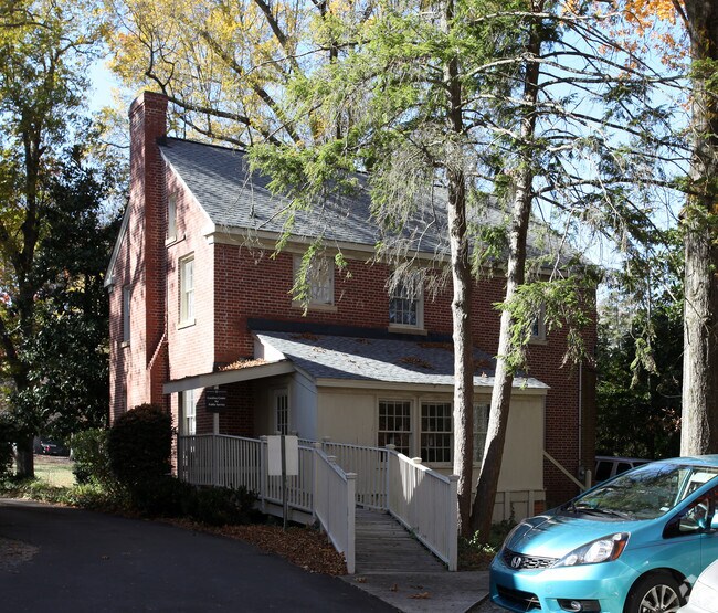
Property Record
211 W Cameron Ave, Chapel Hill, NC 27516
NEARBY LISTINGS FOR SALE OR LEASE
Property Detail
211 W Cameron Ave
9788352873
S/S CAMERON AVE P87/137
Officebuilding
Orange
X
North Carolina
3710978800K
1.03 AC
2025
Orange County
2025
Raleigh/Durham
011700
Durham-Chapel Hill, NC
6,308 SF
DEMOGRAPHICS near 211 W Cameron Ave
1 Mile
3 Mile
5 Mile
2024 Total Population
19,663
65,048
108,405
2029 Population
18,624
60,888
103,733
Pop Growth 2024-2029
(5.28%)
(6.40%)
(4.31%)
Average Age
28
35
38
2024 Total Households
5,445
24,525
43,022
HH Growth 2024-2029
(7.00%)
(7.22%)
(4.33%)
Median Household Inc
$36,288
$70,170
$86,135
Avg Household Size
2.30
2.20
2.20
2024 Avg HH Vehicles
2.00
2.00
2.00
Median Home Value
$483,441
$486,308
$466,710
Median Year Built
1981
1984
1991
Nearby Places
- Restaurants
- Banks
- Shops
- Fitness
- Groceries
PUBLIC TRANSPORTATION
AIRPORT
Raleigh-Durham International
DRIVE
WALK
Distance
Raleigh-Durham International
29 min
17.5 mi
SALE & LEASE HISTORY
LISTING DATE
SALE/LEASE

Aug 21, 2018
For Lease
Nearby Properties
Address
Land Use
TOTAL SIZE
Lot Size
Zoning
Address
Land Use
TOTAL SIZE
Lot Size
Zoning
104,541 SF
404.01 AC
Address
Land Use
TOTAL SIZE
Lot Size
Zoning
215,860 SF
12.28 AC
Address
Land Use
TOTAL SIZE
Lot Size
Zoning
264,710 SF
32.50 AC
R1
Address
Land Use
TOTAL SIZE
Lot Size
Zoning
116,223 SF
34.65 AC
Address
Land Use
TOTAL SIZE
Lot Size
Zoning
244,609 SF
2.72 AC
Address
Land Use
TOTAL SIZE
Lot Size
Zoning
208,406 SF
120.44 AC
R1
Address
Land Use
TOTAL SIZE
Lot Size
Zoning
575,091 SF
3.21 AC
Address
Land Use
TOTAL SIZE
Lot Size
Zoning
4,128 SF
678.68 AC
R1
Address
Land Use
TOTAL SIZE
Lot Size
Zoning
81,191 SF
12.33 AC
OI4
Address
Land Use
TOTAL SIZE
Lot Size
Zoning
55,318 SF
9.05 AC
R4
Address
Land Use
TOTAL SIZE
Lot Size
Zoning
2,748 SF
17.80 AC
R-5-CZD
Address
Land Use
TOTAL SIZE
Lot Size
Zoning
238,990 SF
2.43 AC
Address
Land Use
TOTAL SIZE
Lot Size
Zoning
134,448 SF
59.23 AC
Address
Land Use
TOTAL SIZE
Lot Size
Zoning
287,718 SF
4.97 AC
Address
Land Use
TOTAL SIZE
Lot Size
Zoning
150,677 SF
2.93 AC
Address
Land Use
TOTAL SIZE
Lot Size
Zoning
144,619 SF
3.22 AC
Address
Land Use
TOTAL SIZE
Lot Size
Zoning
119,585 SF
62.30 AC
Address
Land Use
TOTAL SIZE
Lot Size
Zoning
21,078 SF
227.43 AC
OI3R2
Address
Land Use
TOTAL SIZE
Lot Size
Zoning
135,540 SF
4.34 AC
Address
Land Use
TOTAL SIZE
Lot Size
Zoning
26,328 SF
13.86 AC
OR3
Address
Land Use
TOTAL SIZE
Lot Size
Zoning
30,300 SF
13.83 AC
Address
Land Use
TOTAL SIZE
Lot Size
Zoning
361,420 SF
1.68 AC
Address
Land Use
TOTAL SIZE
Lot Size
Zoning
85,652 SF
16.49 AC
R1R5
Address
Land Use
TOTAL SIZE
Lot Size
Zoning
28,272 SF
21.12 AC
OI2R4
Address
Land Use
TOTAL SIZE
Lot Size
Zoning
17,640 SF
11.51 AC
R4R5C
Address
Land Use
TOTAL SIZE
Lot Size
Zoning
119,517 SF
28.28 AC
R20
Address
Land Use
TOTAL SIZE
Lot Size
Zoning
13,912 SF
18.61 AC
NCR5
Address
Land Use
TOTAL SIZE
Lot Size
Zoning
24,820 SF
1 AC
Address
Land Use
TOTAL SIZE
Lot Size
Zoning
143,750 SF
1.32 AC
OI3OI4
Address
Land Use
TOTAL SIZE
Lot Size
Zoning
174,922 SF
4.59 AC
OI4
The World's #1 Commercial Real Estate Marketplace
Connect with us
© 2025 CoStar Group
The information above has been obtained from sources believed reliable. While we do not doubt its accuracy we have not verified it and make no guarantee, warranty or representation about it. It is your responsibility to independently confirm its accuracy and completeness. Any projections, opinions, assumptions, or estimates used are for example only and do not represent the current or future performance of the property. The value of this transaction to you depends on tax and other factors which should be evaluated by your tax, financial, and legal advisors. You and your advisors should conduct a careful, independent investigation of the property to determine to your satisfaction the suitability of the property for your needs.