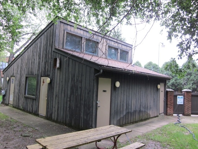
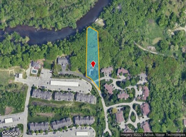
Property Record
2070 Brockton Blvd, Flint, MI 48532
NEARBY LISTINGS FOR SALE OR LEASE
Property Detail
2070 Brockton Blvd
07-05-400-018
3 EXPIRING 12/30/2017. PROPERTY EXEMPT FROM AD VALOREM TAXES AND ASSESSED PURSUANT TO PA 261 OF 2003 EXPIRING 12/30/2017.
Commercialnec
Genesee
AE
Michigan
26049C0167D
3-4
2024
1.48 AC
2025
Flint
010810
Detroit
760 SF
Flint, MI
DEMOGRAPHICS near 2070 Brockton Blvd
1 Mile
3 Mile
5 Mile
2024 Total Population
3,739
40,315
105,746
2029 Population
3,612
39,985
106,521
Pop Growth 2024-2029
(3.40%)
(0.82%)
+ 0.73%
Average Age
43
41
41
2024 Total Households
1,505
16,679
44,046
HH Growth 2024-2029
(3.39%)
(0.92%)
+ 0.74%
Median Household Inc
$50,247
$46,949
$42,037
Avg Household Size
2.30
2.30
2.30
2024 Avg HH Vehicles
2.00
2.00
1.00
Median Home Value
$169,560
$111,858
$92,918
Median Year Built
1970
1966
1963
Nearby Places
Map Layers
Map Styles
 Street
 Aerial
- Restaurants
- Banks
- Shops
- Fitness
- Groceries
PUBLIC TRANSPORTATION
COMMUTER RAIL
Flint Amtrak Station (Blue Water - Amtrak)
DRIVE
WALK
Distance
Flint Amtrak Station (Blue Water - Amtrak)
17 min
9.2 mi
AIRPORT
Bishop International
DRIVE
WALK
Distance
Bishop International
20 min
7.3 mi
Freight Ports
Port of Toledo
DRIVE
WALK
Distance
Port of Toledo
138 min
115.7 mi
Nearby Properties
Address
Land Use
TOTAL SIZE
Lot Size
Zoning
Address
Land Use
TOTAL SIZE
Lot Size
Zoning
101,590 SF
5.54 AC
Address
Land Use
TOTAL SIZE
Lot Size
Zoning
54,651 SF
3.06 AC
Address
Land Use
TOTAL SIZE
Lot Size
Zoning
571,389 SF
584 AC
Address
Land Use
TOTAL SIZE
Lot Size
Zoning
99,992 SF
8.39 AC
Address
Land Use
TOTAL SIZE
Lot Size
Zoning
59,232 SF
3.65 AC
Address
Land Use
TOTAL SIZE
Lot Size
Zoning
247,555 SF
198 AC
Address
Land Use
TOTAL SIZE
Lot Size
Zoning
85,936 SF
12.71 AC
Address
Land Use
TOTAL SIZE
Lot Size
Zoning
61,892 SF
10.61 AC
Address
Land Use
TOTAL SIZE
Lot Size
Zoning
76,823 SF
114 AC
Address
Land Use
TOTAL SIZE
Lot Size
Zoning
23,500 SF
4.96 AC
Address
Land Use
TOTAL SIZE
Lot Size
Zoning
207,043 SF
24.20 AC
Address
Land Use
TOTAL SIZE
Lot Size
Zoning
214,422 SF
208 AC
Address
Land Use
TOTAL SIZE
Lot Size
Zoning
92,158 SF
8.40 AC
FM,MULT
Address
Land Use
TOTAL SIZE
Lot Size
Zoning
187,019 SF
180 AC
Address
Land Use
TOTAL SIZE
Lot Size
Zoning
290,502 SF
272.83 AC
Address
Land Use
TOTAL SIZE
Lot Size
Zoning
157,068 SF
160 AC
Address
Land Use
TOTAL SIZE
Lot Size
Zoning
11.97 AC
Address
Land Use
TOTAL SIZE
Lot Size
Zoning
209,058 SF
9.02 AC
Address
Land Use
TOTAL SIZE
Lot Size
Zoning
95,300 SF
9.26 AC
Address
Land Use
TOTAL SIZE
Lot Size
Zoning
403,803 SF
252 AC
Address
Land Use
TOTAL SIZE
Lot Size
Zoning
10.30 AC
Address
Land Use
TOTAL SIZE
Lot Size
Zoning
41,298 SF
9.49 AC
Address
Land Use
TOTAL SIZE
Lot Size
Zoning
Address
Land Use
TOTAL SIZE
Lot Size
Zoning
44,864 SF
5.54 AC
Address
Land Use
TOTAL SIZE
Lot Size
Zoning
59,173 SF
11.43 AC
Address
Land Use
TOTAL SIZE
Lot Size
Zoning
55,979 SF
13.87 AC
Address
Land Use
TOTAL SIZE
Lot Size
Zoning
95,813 SF
11.26 AC
Address
Land Use
TOTAL SIZE
Lot Size
Zoning
135,350 SF
12.53 AC
Address
Land Use
TOTAL SIZE
Lot Size
Zoning
224,263 SF
24.98 AC
CC
Address
Land Use
TOTAL SIZE
Lot Size
Zoning
22,792 SF
3.89 AC
The World's #1 Commercial Real Estate Marketplace
Connect with us
© 2025 CoStar Group
The information above has been obtained from sources believed reliable. While we do not doubt its accuracy we have not verified it and make no guarantee, warranty or representation about it. It is your responsibility to independently confirm its accuracy and completeness. Any projections, opinions, assumptions, or estimates used are for example only and do not represent the current or future performance of the property. The value of this transaction to you depends on tax and other factors which should be evaluated by your tax, financial, and legal advisors. You and your advisors should conduct a careful, independent investigation of the property to determine to your satisfaction the suitability of the property for your needs.