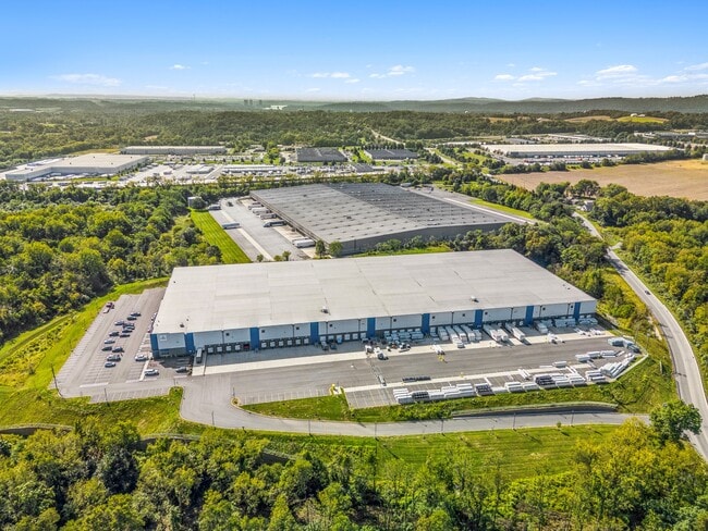
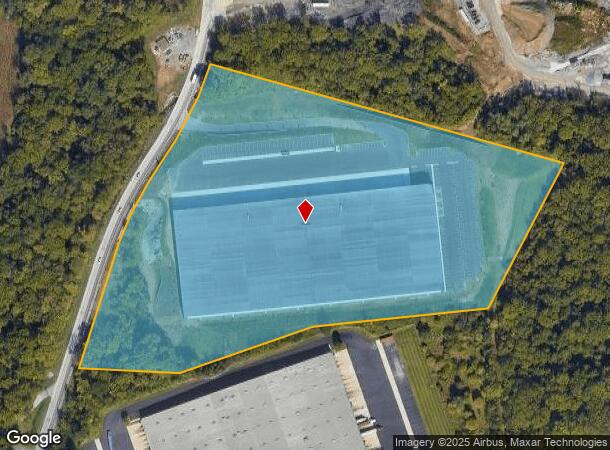
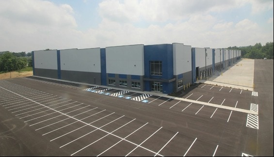
Property Record
2070 N Union St, Middletown, PA 17057
NEARBY LISTINGS FOR SALE OR LEASE
Property Detail
2070 N Union St
Harrisburg-Carlisle, PA
Dauphin
36-006-033
Pennsylvania
Warehouse
18.43 AC
2025
Harrisburg Area East
2025
Philadelphia
023601
DEMOGRAPHICS near 2070 N Union St
1 Mile
3 Mile
5 Mile
2024 Total Population
2,005
36,222
90,489
2029 Population
2,036
36,867
92,029
Pop Growth 2024-2029
+ 1.55%
+ 1.78%
+ 1.70%
Average Age
39
41
41
2024 Total Households
703
14,602
36,524
HH Growth 2024-2029
+ 1.71%
+ 1.89%
+ 1.79%
Median Household Inc
$107,627
$81,478
$76,204
Avg Household Size
2.80
2.40
2.40
2024 Avg HH Vehicles
2.00
2.00
2.00
Median Home Value
$352,304
$208,345
$213,016
Median Year Built
2000
1978
1975
Nearby Places
Map Layers
Map Styles
 Street
 Aerial
- Restaurants
- Banks
- Shops
- Fitness
- Groceries
PUBLIC TRANSPORTATION
COMMUTER RAIL
Middletown (Keystone Service - Amtrak)
DRIVE
WALK
Distance
Middletown (Keystone Service - Amtrak)
12 min
3.8 mi
AIRPORT
Harrisburg International
DRIVE
WALK
Distance
Harrisburg International
11 min
4.8 mi
Freight Ports
Port of Baltimore
DRIVE
WALK
Distance
Port of Baltimore
120 min
86.0 mi
SALE & LEASE HISTORY
LISTING DATE
SALE/LEASE

Sep 14, 2020
For Lease
Apr 08, 2021
For Lease
Nearby Properties
Address
Land Use
TOTAL SIZE
Lot Size
Zoning
Address
Land Use
TOTAL SIZE
Lot Size
Zoning
185,784 SF
173.81 AC
Address
Land Use
TOTAL SIZE
Lot Size
Zoning
72,186 SF
117.61 AC
Address
Land Use
TOTAL SIZE
Lot Size
Zoning
240,000 SF
68.73 AC
Address
Land Use
TOTAL SIZE
Lot Size
Zoning
29,440 SF
82.92 AC
Address
Land Use
TOTAL SIZE
Lot Size
Zoning
4,176 SF
192.96 AC
Address
Land Use
TOTAL SIZE
Lot Size
Zoning
3,029 SF
54.26 AC
Address
Land Use
TOTAL SIZE
Lot Size
Zoning
142,010 SF
53.46 AC
Address
Land Use
TOTAL SIZE
Lot Size
Zoning
50,963 SF
46.61 AC
Address
Land Use
TOTAL SIZE
Lot Size
Zoning
211,430 SF
38.50 AC
Address
Land Use
TOTAL SIZE
Lot Size
Zoning
5,396 SF
49.35 AC
Address
Land Use
TOTAL SIZE
Lot Size
Zoning
651,250 SF
47.13 AC
Address
Land Use
TOTAL SIZE
Lot Size
Zoning
1,196 SF
50.34 AC
Address
Land Use
TOTAL SIZE
Lot Size
Zoning
3,232 SF
38.86 AC
Address
Land Use
TOTAL SIZE
Lot Size
Zoning
507,000 SF
32.82 AC
Address
Land Use
TOTAL SIZE
Lot Size
Zoning
95,192 SF
52.43 AC
Address
Land Use
TOTAL SIZE
Lot Size
Zoning
348,615 SF
38.98 AC
Address
Land Use
TOTAL SIZE
Lot Size
Zoning
2,400 SF
9.11 AC
Address
Land Use
TOTAL SIZE
Lot Size
Zoning
320,000 SF
16.71 AC
Address
Land Use
TOTAL SIZE
Lot Size
Zoning
77,280 SF
9.60 AC
Address
Land Use
TOTAL SIZE
Lot Size
Zoning
196,000 SF
12.42 AC
Address
Land Use
TOTAL SIZE
Lot Size
Zoning
249,112 SF
24.01 AC
Address
Land Use
TOTAL SIZE
Lot Size
Zoning
300,000 SF
17.71 AC
Address
Land Use
TOTAL SIZE
Lot Size
Zoning
132,588 SF
18.49 AC
Address
Land Use
TOTAL SIZE
Lot Size
Zoning
59,760 SF
61.67 AC
Address
Land Use
TOTAL SIZE
Lot Size
Zoning
137,640 SF
12.87 AC
Address
Land Use
TOTAL SIZE
Lot Size
Zoning
96,099 SF
10.80 AC
Address
Land Use
TOTAL SIZE
Lot Size
Zoning
73,141 SF
4.40 AC
Address
Land Use
TOTAL SIZE
Lot Size
Zoning
3,698 SF
250.35 AC
Address
Land Use
TOTAL SIZE
Lot Size
Zoning
56.58 AC
The World's #1 Commercial Real Estate Marketplace
Connect with us
© 2025 CoStar Group
The information above has been obtained from sources believed reliable. While we do not doubt its accuracy we have not verified it and make no guarantee, warranty or representation about it. It is your responsibility to independently confirm its accuracy and completeness. Any projections, opinions, assumptions, or estimates used are for example only and do not represent the current or future performance of the property. The value of this transaction to you depends on tax and other factors which should be evaluated by your tax, financial, and legal advisors. You and your advisors should conduct a careful, independent investigation of the property to determine to your satisfaction the suitability of the property for your needs.