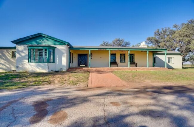
Property Record
W Ih 20, Odessa, TX


Current Lease Availabilities
NEARBY LISTINGS FOR SALE OR LEASE
-
-
View all Odessa listings for lease on LoopNet.com
Property Detail
W Ih 20
42470-00022-00000
T-2-S BLK 42 SEC 42 (CARD #1)
Pasture
Ector
A
Texas
48135C0350E
7.64 AC
2025
Midland & Odessa
2025
Other Market Areas
002802
Odessa, TX
DEMOGRAPHICS near W Ih 20
1 Mile
3 Mile
5 Mile
2024 Total Population
40
15,659
61,009
2029 Population
39
15,264
59,605
Pop Growth 2024-2029
(2.50%)
(2.52%)
(2.30%)
Average Age
33
35
34
2024 Total Households
13
5,338
20,428
HH Growth 2024-2029
0.00%
(2.90%)
(2.65%)
Median Household Inc
$44,999
$42,232
$44,232
Avg Household Size
2.90
2.80
2.80
2024 Avg HH Vehicles
2.00
2.00
2.00
Median Home Value
$71,428
$98,592
$100,933
Median Year Built
1989
1974
1973
Nearby Places
- Restaurants
- Banks
- Shops
- Fitness
- Groceries
PUBLIC TRANSPORTATION
AIRPORT
Midland International Air And Space Port
DRIVE
WALK
Distance
Midland International Air And Space Port
22 min
16.7 mi
Freight Ports
Port of Corpus Christi
DRIVE
WALK
Distance
Port of Corpus Christi
498 min
482.5 mi
Nearby Properties
Address
Land Use
TOTAL SIZE
Lot Size
Zoning
Address
Land Use
TOTAL SIZE
Lot Size
Zoning
9,560 SF
141.91 AC
ES1
Address
Land Use
TOTAL SIZE
Lot Size
Zoning
34,762 SF
77.94 AC
ES1
Address
Land Use
TOTAL SIZE
Lot Size
Zoning
232,969 SF
19.81 AC
EB7
Address
Land Use
TOTAL SIZE
Lot Size
Zoning
214,832 SF
10.42 AC
EB5
Address
Land Use
TOTAL SIZE
Lot Size
Zoning
36,648 SF
86.41 AC
ES1
Address
Land Use
TOTAL SIZE
Lot Size
Zoning
11,600 SF
28.47 AC
ES1
Address
Land Use
TOTAL SIZE
Lot Size
Zoning
5,826 SF
32.11 AC
ES1
Address
Land Use
TOTAL SIZE
Lot Size
Zoning
26,482 SF
4.56 AC
EW1
Address
Land Use
TOTAL SIZE
Lot Size
Zoning
17,000 SF
10.29 AC
ES1
Address
Land Use
TOTAL SIZE
Lot Size
Zoning
61,570 SF
6.44 AC
ES1
Address
Land Use
TOTAL SIZE
Lot Size
Zoning
27,350 SF
30.13 AC
EB7
Address
Land Use
TOTAL SIZE
Lot Size
Zoning
3,141 SF
2.92 AC
EB7
Address
Land Use
TOTAL SIZE
Lot Size
Zoning
15,200 SF
29.64 AC
ES1
Address
Land Use
TOTAL SIZE
Lot Size
Zoning
9,754 SF
14.89 AC
ES1
Address
Land Use
TOTAL SIZE
Lot Size
Zoning
47,000 SF
17.51 AC
EB7
Address
Land Use
TOTAL SIZE
Lot Size
Zoning
2,592 SF
61.28 AC
ES1
Address
Land Use
TOTAL SIZE
Lot Size
Zoning
90,450 SF
2.07 AC
EB6
Address
Land Use
TOTAL SIZE
Lot Size
Zoning
6,696 SF
9.25 AC
EW1
Address
Land Use
TOTAL SIZE
Lot Size
Zoning
74,637 SF
10.13 AC
EB5
Address
Land Use
TOTAL SIZE
Lot Size
Zoning
750 SF
13.58 AC
EW3
Address
Land Use
TOTAL SIZE
Lot Size
Zoning
77,326 SF
1.96 AC
EB7
Address
Land Use
TOTAL SIZE
Lot Size
Zoning
2,000 SF
4.56 AC
EB7
Address
Land Use
TOTAL SIZE
Lot Size
Zoning
2,752 SF
3.43 AC
EB7
Address
Land Use
TOTAL SIZE
Lot Size
Zoning
17,502 SF
3.49 AC
EB5
Address
Land Use
TOTAL SIZE
Lot Size
Zoning
24,386 SF
9.99 AC
EB5
Address
Land Use
TOTAL SIZE
Lot Size
Zoning
8,266 SF
8.91 AC
ES2
Address
Land Use
TOTAL SIZE
Lot Size
Zoning
3,920 SF
40.10 AC
ES1
Address
Land Use
TOTAL SIZE
Lot Size
Zoning
1,680 SF
7.16 AC
ES1
Address
Land Use
TOTAL SIZE
Lot Size
Zoning
27,630 SF
9.01 AC
EB5
Address
Land Use
TOTAL SIZE
Lot Size
Zoning
20,301 SF
6.20 AC
EB7
The World's #1 Commercial Real Estate Marketplace
Connect with us
© 2025 CoStar Group
The information above has been obtained from sources believed reliable. While we do not doubt its accuracy we have not verified it and make no guarantee, warranty or representation about it. It is your responsibility to independently confirm its accuracy and completeness. Any projections, opinions, assumptions, or estimates used are for example only and do not represent the current or future performance of the property. The value of this transaction to you depends on tax and other factors which should be evaluated by your tax, financial, and legal advisors. You and your advisors should conduct a careful, independent investigation of the property to determine to your satisfaction the suitability of the property for your needs.