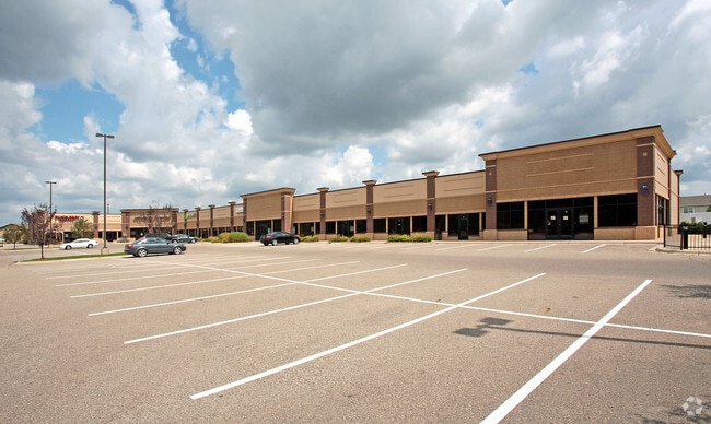
Property Record
20700 Chippendale Ave W, Farmington, MN 55024


NEARBY LISTINGS FOR SALE OR LEASE
Property Detail
20700 Chippendale Ave W
Minneapolis-St. Paul-Bloomington, MN-WI
Tamarack Ridge 4Th Add
14-74903-01-020
TAMARACK RIDGE 4TH ADD 2 1
Commercialnec
Dakota
X
Minnesota
27037C0219E
20
2024
2.63 AC
2024
Apple Vly/Lakeville
060905
Minneapolis/St Paul
25,621 SF
DEMOGRAPHICS near 20700 Chippendale Ave W
1 Mile
3 Mile
5 Mile
2024 Total Population
6,793
23,345
48,264
2029 Population
6,949
23,865
49,674
Pop Growth 2024-2029
+ 2.30%
+ 2.23%
+ 2.92%
Average Age
35
36
36
2024 Total Households
2,326
7,753
15,988
HH Growth 2024-2029
+ 2.19%
+ 2.15%
+ 2.98%
Median Household Inc
$87,775
$109,618
$112,589
Avg Household Size
2.80
2.90
2.90
2024 Avg HH Vehicles
2.00
2.00
2.00
Median Home Value
$276,912
$331,326
$348,082
Median Year Built
1995
1999
2000
Nearby Places
Map Layers
Map Styles
 Street
 Aerial
- Restaurants
- Banks
- Shops
- Fitness
- Groceries
PUBLIC TRANSPORTATION
AIRPORT
Minneapolis-St Paul International/Wold-Chamberlain
DRIVE
WALK
Distance
Minneapolis-St Paul International/Wold-Chamberlain
34 min
22.4 mi
Freight Ports
Port Milwaukee
DRIVE
WALK
Distance
Port Milwaukee
376 min
338.0 mi
SALE & LEASE HISTORY
LISTING DATE
SALE/LEASE

Sep 25, 2016
For Lease
Apr 03, 2019
For Lease
Nearby Properties
Address
Land Use
TOTAL SIZE
Lot Size
Zoning
Address
Land Use
TOTAL SIZE
Lot Size
Zoning
78.77 AC
Address
Land Use
TOTAL SIZE
Lot Size
Zoning
147,983 SF
46.75 AC
Address
Land Use
TOTAL SIZE
Lot Size
Zoning
147,426 SF
29.47 AC
Address
Land Use
TOTAL SIZE
Lot Size
Zoning
160,611 SF
14.08 AC
Address
Land Use
TOTAL SIZE
Lot Size
Zoning
141,819 SF
12.95 AC
Address
Land Use
TOTAL SIZE
Lot Size
Zoning
79,076 SF
3.14 AC
Address
Land Use
TOTAL SIZE
Lot Size
Zoning
92,744 SF
31.10 AC
Address
Land Use
TOTAL SIZE
Lot Size
Zoning
94,244 SF
4.06 AC
Address
Land Use
TOTAL SIZE
Lot Size
Zoning
176,291 SF
13.79 AC
Address
Land Use
TOTAL SIZE
Lot Size
Zoning
48,990 SF
1.19 AC
Address
Land Use
TOTAL SIZE
Lot Size
Zoning
105,040 SF
19.97 AC
Address
Land Use
TOTAL SIZE
Lot Size
Zoning
77,816 SF
18.01 AC
Address
Land Use
TOTAL SIZE
Lot Size
Zoning
115,984 SF
0.47 AC
Address
Land Use
TOTAL SIZE
Lot Size
Zoning
69,984 SF
4.66 AC
Address
Land Use
TOTAL SIZE
Lot Size
Zoning
11.63 AC
Address
Land Use
TOTAL SIZE
Lot Size
Zoning
37,738 SF
4.68 AC
Address
Land Use
TOTAL SIZE
Lot Size
Zoning
46,380 SF
4.78 AC
Address
Land Use
TOTAL SIZE
Lot Size
Zoning
49,001 SF
4.41 AC
Address
Land Use
TOTAL SIZE
Lot Size
Zoning
26,840 SF
9.16 AC
Address
Land Use
TOTAL SIZE
Lot Size
Zoning
78,483 SF
9.72 AC
Address
Land Use
TOTAL SIZE
Lot Size
Zoning
48,056 SF
4.22 AC
Address
Land Use
TOTAL SIZE
Lot Size
Zoning
94,882 SF
5 AC
Address
Land Use
TOTAL SIZE
Lot Size
Zoning
33,480 SF
3.38 AC
Address
Land Use
TOTAL SIZE
Lot Size
Zoning
5.71 AC
Address
Land Use
TOTAL SIZE
Lot Size
Zoning
30,758 SF
1.31 AC
Address
Land Use
TOTAL SIZE
Lot Size
Zoning
15,207 SF
1.58 AC
Address
Land Use
TOTAL SIZE
Lot Size
Zoning
27,200 SF
7.76 AC
Address
Land Use
TOTAL SIZE
Lot Size
Zoning
25,876 SF
1.68 AC
Address
Land Use
TOTAL SIZE
Lot Size
Zoning
14,341 SF
2.26 AC
The World's #1 Commercial Real Estate Marketplace
Connect with us
© 2026 CoStar Group
The information above has been obtained from sources believed reliable. While we do not doubt its accuracy we have not verified it and make no guarantee, warranty or representation about it. It is your responsibility to independently confirm its accuracy and completeness. Any projections, opinions, assumptions, or estimates used are for example only and do not represent the current or future performance of the property. The value of this transaction to you depends on tax and other factors which should be evaluated by your tax, financial, and legal advisors. You and your advisors should conduct a careful, independent investigation of the property to determine to your satisfaction the suitability of the property for your needs.