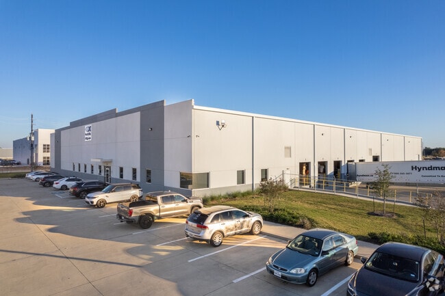
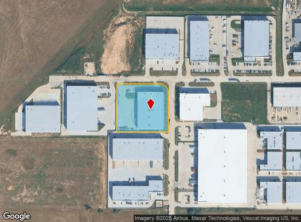
Property Record
20701 Clay Center Dr, Katy, TX 77449

NEARBY LISTINGS FOR SALE OR LEASE
Property Detail
20701 Clay Center Dr
1406410020002
Clay Road Commerce Park
Lightindustrial
RES B1 BLK 2 CLAY ROAD COMMERCE PARK
X
Harris
48201C0605M
Texas
2024
2.69 AC
2025
Northwest Outliers
542202
Houston
46,116 SF
Houston-Pasadena-The Woodlands, TX
DEMOGRAPHICS near 20701 Clay Center Dr
1 Mile
3 Mile
5 Mile
2024 Total Population
16,999
137,516
313,227
2029 Population
17,654
141,291
322,285
Pop Growth 2024-2029
+ 3.85%
+ 2.75%
+ 2.89%
Average Age
33
34
35
2024 Total Households
4,712
40,923
98,002
HH Growth 2024-2029
+ 3.78%
+ 2.64%
+ 2.82%
Median Household Inc
$83,997
$81,251
$83,453
Avg Household Size
3.50
3.30
3.10
2024 Avg HH Vehicles
2.00
2.00
2.00
Median Home Value
$222,984
$211,282
$225,516
Median Year Built
2008
2005
2003
Nearby Places
Map Layers
Map Styles
 Street
 Aerial
- Restaurants
- Banks
- Shops
- Fitness
- Groceries
PUBLIC TRANSPORTATION
AIRPORT
George Bush Intcntl/Houston
DRIVE
WALK
Distance
George Bush Intcntl/Houston
47 min
34.5 mi
Freight Ports
Port of Houston
DRIVE
WALK
Distance
Port of Houston
53 min
36.2 mi
Nearby Properties
Address
Land Use
TOTAL SIZE
Lot Size
Zoning
Address
Land Use
TOTAL SIZE
Lot Size
Zoning
807,360 SF
54.15 AC
Address
Land Use
TOTAL SIZE
Lot Size
Zoning
838,700 SF
36.68 AC
Address
Land Use
TOTAL SIZE
Lot Size
Zoning
891,129 SF
44.39 AC
Address
Land Use
TOTAL SIZE
Lot Size
Zoning
339,835 SF
12.09 AC
Address
Land Use
TOTAL SIZE
Lot Size
Zoning
290,973 SF
15 AC
Address
Land Use
TOTAL SIZE
Lot Size
Zoning
347,834 SF
15.25 AC
Address
Land Use
TOTAL SIZE
Lot Size
Zoning
272,033 SF
12.74 AC
Address
Land Use
TOTAL SIZE
Lot Size
Zoning
335,899 SF
12.62 AC
Address
Land Use
TOTAL SIZE
Lot Size
Zoning
395,495 SF
13.83 AC
Address
Land Use
TOTAL SIZE
Lot Size
Zoning
331,263 SF
11.36 AC
Address
Land Use
TOTAL SIZE
Lot Size
Zoning
266,532 SF
6.45 AC
Address
Land Use
TOTAL SIZE
Lot Size
Zoning
292,645 SF
12.71 AC
Address
Land Use
TOTAL SIZE
Lot Size
Zoning
439,808 SF
23.75 AC
Address
Land Use
TOTAL SIZE
Lot Size
Zoning
385,744 SF
25.88 AC
Address
Land Use
TOTAL SIZE
Lot Size
Zoning
236,406 SF
11.40 AC
Address
Land Use
TOTAL SIZE
Lot Size
Zoning
375,152 SF
19.57 AC
Address
Land Use
TOTAL SIZE
Lot Size
Zoning
262,174 SF
11.64 AC
Address
Land Use
TOTAL SIZE
Lot Size
Zoning
334,971 SF
18.43 AC
Address
Land Use
TOTAL SIZE
Lot Size
Zoning
262,943 SF
11.51 AC
Address
Land Use
TOTAL SIZE
Lot Size
Zoning
131,544 SF
19.04 AC
Address
Land Use
TOTAL SIZE
Lot Size
Zoning
235,154 SF
13 AC
Address
Land Use
TOTAL SIZE
Lot Size
Zoning
693,781 SF
6.86 AC
Address
Land Use
TOTAL SIZE
Lot Size
Zoning
420,370 SF
17.05 AC
Address
Land Use
TOTAL SIZE
Lot Size
Zoning
151,385 SF
8.58 AC
Address
Land Use
TOTAL SIZE
Lot Size
Zoning
270,000 SF
14.25 AC
Address
Land Use
TOTAL SIZE
Lot Size
Zoning
211,757 SF
9.02 AC
Address
Land Use
TOTAL SIZE
Lot Size
Zoning
122,133 SF
13.46 AC
Address
Land Use
TOTAL SIZE
Lot Size
Zoning
54,306 SF
3.78 AC
Address
Land Use
TOTAL SIZE
Lot Size
Zoning
193,230 SF
16.92 AC
Address
Land Use
TOTAL SIZE
Lot Size
Zoning
111,780 SF
12.75 AC
The World's #1 Commercial Real Estate Marketplace
Connect with us
© 2026 CoStar Group
The information above has been obtained from sources believed reliable. While we do not doubt its accuracy we have not verified it and make no guarantee, warranty or representation about it. It is your responsibility to independently confirm its accuracy and completeness. Any projections, opinions, assumptions, or estimates used are for example only and do not represent the current or future performance of the property. The value of this transaction to you depends on tax and other factors which should be evaluated by your tax, financial, and legal advisors. You and your advisors should conduct a careful, independent investigation of the property to determine to your satisfaction the suitability of the property for your needs.