Property Record
20701 E 81St St S, Broken Arrow, OK 74014
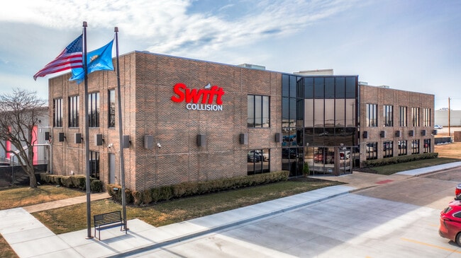


This Property Is For Sale
Property Detail
20701 E 81St St S
Tulsa, OK
AES INDUSTRIAL CTR LOT 1
730054406
Wagoner
Officebuilding
Oklahoma
B and X Area of moderate flood hazard, usually the area between the limits of the 100-year and 500-year floods.
1
2025
8.23 AC
2025
Wagoner County
030502
Tulsa
319 SF
NEARBY LISTINGS FOR SALE OR LEASE
DEMOGRAPHICS near 20701 E 81St St S
1 mile
3 mile
5 mile
2025 Total Population
2,534
33,702
115,520
2030 Population
2,777
36,078
121,759
Pop Growth 2025-2030
+ 9.59%
+ 7.05%
+ 5.40%
Average Age
40
40
39
2025 Total Households
930
12,801
43,122
HH Growth 2025-2030
+ 9.25%
+ 6.85%
+ 5.26%
Median Household Inc
$87,019
$83,432
$86,349
Avg Household Size
2.70
2.60
2.60
2025 Avg HH Vehicles
2.00
2.00
2.00
Median Home Value
$226,378
$260,056
$254,215
Median Year Built
1984
1990
1995
Nearby Places
Map Layers
Map Styles
 Street
 Aerial
Transit
 Traffic
 Biking
Places
Listings with unknown addresses are not visible on the map
- Restaurants
- Banks
- Shops
- Fitness
- Groceries
PUBLIC TRANSPORTATION
AIRPORT
Tulsa International
Drive
Walk
Distance
Tulsa International
27 min
18.6 mi
Freight Ports
Tulsa Port of Inola
Drive
Walk
Distance
Tulsa Port of Inola
32 min
24.1 mi
Nearby Properties
Address
Land Use
TOTAL SIZE
Lot Size
Zoning
Address
Land Use
TOTAL SIZE
Lot Size
Zoning
75,444 SF
23.92 AC
R1
Address
Land Use
TOTAL SIZE
Lot Size
Zoning
58,695 SF
5.34 AC
RM
Address
Land Use
TOTAL SIZE
Lot Size
Zoning
77,260 SF
0.58 AC
R3
Address
Land Use
TOTAL SIZE
Lot Size
Zoning
67,149 SF
28.56 AC
R2
Address
Land Use
TOTAL SIZE
Lot Size
Zoning
363,154 SF
23.09 AC
IL
Address
Land Use
TOTAL SIZE
Lot Size
Zoning
39,733 SF
9.36 AC
A1
Address
Land Use
TOTAL SIZE
Lot Size
Zoning
11,601 SF
38.18 AC
RS1
Address
Land Use
TOTAL SIZE
Lot Size
Zoning
13,691 SF
2.04 AC
CH
Address
Land Use
TOTAL SIZE
Lot Size
Zoning
28,071 SF
19 AC
Address
Land Use
TOTAL SIZE
Lot Size
Zoning
28,348 SF
0.90 AC
DM
Address
Land Use
TOTAL SIZE
Lot Size
Zoning
51,741 SF
2.41 AC
R3
Address
Land Use
TOTAL SIZE
Lot Size
Zoning
60,460 SF
2.28 AC
NCU
Address
Land Use
TOTAL SIZE
Lot Size
Zoning
10,140 SF
18.57 AC
R1
Address
Land Use
TOTAL SIZE
Lot Size
Zoning
23,283 SF
3.94 AC
A1
Address
Land Use
TOTAL SIZE
Lot Size
Zoning
12,497 SF
3.31 AC
R1
Address
Land Use
TOTAL SIZE
Lot Size
Zoning
27,477 SF
5.79 AC
R1
Address
Land Use
TOTAL SIZE
Lot Size
Zoning
33,004 SF
3.23 AC
R2
Address
Land Use
TOTAL SIZE
Lot Size
Zoning
255,328 SF
27.50 AC
IL
Address
Land Use
TOTAL SIZE
Lot Size
Zoning
11,100 SF
5.30 AC
R1
Address
Land Use
TOTAL SIZE
Lot Size
Zoning
Address
Land Use
TOTAL SIZE
Lot Size
Zoning
21,960 SF
0.24 AC
CH
Address
Land Use
TOTAL SIZE
Lot Size
Zoning
38,842 SF
0.96 AC
DM
Address
Land Use
TOTAL SIZE
Lot Size
Zoning
10,700 SF
5.99 AC
RM
Address
Land Use
TOTAL SIZE
Lot Size
Zoning
11,795 SF
5.12 AC
R1
Address
Land Use
TOTAL SIZE
Lot Size
Zoning
33,108 SF
0.96 AC
DM
Address
Land Use
TOTAL SIZE
Lot Size
Zoning
74,293 SF
9.34 AC
CH
Address
Land Use
TOTAL SIZE
Lot Size
Zoning
29,687 SF
3.19 AC
R2
Address
Land Use
TOTAL SIZE
Lot Size
Zoning
72,754 SF
9.18 AC
CH
The World's #1 Commercial Real Estate Marketplace
Connect with us
© 2026 CoStar Group
The information above has been obtained from sources believed reliable. While we do not doubt its accuracy we have not verified it and make no guarantee, warranty or representation about it. It is your responsibility to independently confirm its accuracy and completeness. Any projections, opinions, assumptions, or estimates used are for example only and do not represent the current or future performance of the property. The value of this transaction to you depends on tax and other factors which should be evaluated by your tax, financial, and legal advisors. You and your advisors should conduct a careful, independent investigation of the property to determine to your satisfaction the suitability of the property for your needs.