Property Record
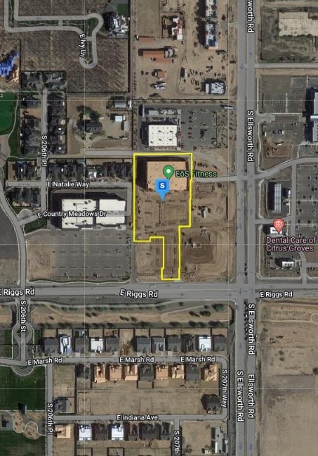
20722 E Riggs Rd, Queen Creek, AZ 85142
Property Detail
20722 E Riggs Rd
Phoenix-Mesa-Chandler, AZ
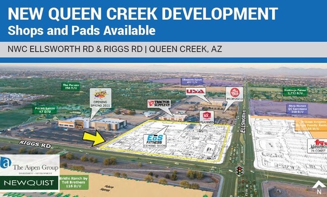
PECAN PLAZA MCR 1634-33
314-02-915
MARICOPA
Gymhealthspa
Arizona
2025
5
2025
4.14 AC
817200
Queen Creek
38,561 SF
Phoenix
NEARBY LISTINGS FOR SALE OR LEASE
-
-
-
-
No Photo
-
View all Queen Creek listings for lease on LoopNet.com
DEMOGRAPHICS near 20722 E Riggs Rd
1 mile
3 mile
5 mile
2025 Total Population
4,749
58,095
168,947
2030 Population
5,142
64,125
189,756
Pop Growth 2025-2030
+ 8.28%
+ 10.38%
+ 12.32%
Average Age
37
36
37
2025 Total Households
1,327
17,291
51,947
HH Growth 2025-2030
+ 8.44%
+ 10.62%
+ 12.47%
Median Household Inc
$150,090
$129,445
$117,819
Avg Household Size
3.50
3.30
3.20
2025 Avg HH Vehicles
3.00
3.00
2.00
Median Home Value
$725,086
$633,152
$555,391
Median Year Built
2011
2010
2010
Nearby Places
Map Layers
Map Styles
 Street
 Aerial
Layers
 Traffic
 Biking
Places
Listings with unknown addresses are not visible on the map
- Restaurants
- Banks
- Shops
- Fitness
- Groceries
PUBLIC TRANSPORTATION
AIRPORT
Phoenix-Mesa Gateway
Drive
Walk
Distance
Phoenix-Mesa Gateway
14 min
7.4 mi
Phoenix Sky Harbor International
Drive
Walk
Distance
Phoenix Sky Harbor International
52 min
36.6 mi
Freight Ports
Port of San Diego
Drive
Walk
Distance
Port of San Diego
413 min
372.7 mi
SALE & LEASE HISTORY
LISTING DATE
SALE/LEASE

Apr 19, 2018
For Lease
Apr 19, 2018
For Lease
Nearby Properties
Address
Land Use
TOTAL SIZE
Lot Size
Zoning
Address
Land Use
TOTAL SIZE
Lot Size
Zoning
23,766 SF
29.45 AC
R-43
Address
Land Use
TOTAL SIZE
Lot Size
Zoning
32,858 SF
13.76 AC
C-G
Address
Land Use
TOTAL SIZE
Lot Size
Zoning
54,689 SF
5.41 AC
R-43
Address
Land Use
TOTAL SIZE
Lot Size
Zoning
53,995 SF
10.12 AC
Address
Land Use
TOTAL SIZE
Lot Size
Zoning
250,050 SF
17.47 AC
Address
Land Use
TOTAL SIZE
Lot Size
Zoning
339,494 SF
48.27 AC
R-4
Address
Land Use
TOTAL SIZE
Lot Size
Zoning
477,934 SF
24.18 AC
MU
Address
Land Use
TOTAL SIZE
Lot Size
Zoning
227,555 SF
53.44 AC
R-43
Address
Land Use
TOTAL SIZE
Lot Size
Zoning
30,624 SF
13.41 AC
Address
Land Use
TOTAL SIZE
Lot Size
Zoning
30,944 SF
7.03 AC
Address
Land Use
TOTAL SIZE
Lot Size
Zoning
97,313 SF
5.69 AC
CB2
Address
Land Use
TOTAL SIZE
Lot Size
Zoning
20,053 SF
3.86 AC
R-43
Address
Land Use
TOTAL SIZE
Lot Size
Zoning
187,208 SF
34.75 AC
MDR
Address
Land Use
TOTAL SIZE
Lot Size
Zoning
6.02 AC
I-1
Address
Land Use
TOTAL SIZE
Lot Size
Zoning
270,126 SF
12.65 AC
C-TC
Address
Land Use
TOTAL SIZE
Lot Size
Zoning
127,184 SF
14.80 AC
R-43
Address
Land Use
TOTAL SIZE
Lot Size
Zoning
117,552 SF
30.35 AC
R143
Address
Land Use
TOTAL SIZE
Lot Size
Zoning
216,568 SF
22.18 AC
C-G
Address
Land Use
TOTAL SIZE
Lot Size
Zoning
89,669 SF
13.60 AC
C-G
Address
Land Use
TOTAL SIZE
Lot Size
Zoning
95,413 SF
11.30 AC
R-43
Address
Land Use
TOTAL SIZE
Lot Size
Zoning
179,893 SF
15 AC
C-G
Address
Land Use
TOTAL SIZE
Lot Size
Zoning
112,277 SF
9.68 AC
C-TC
Address
Land Use
TOTAL SIZE
Lot Size
Zoning
101,394 SF
8.70 AC
MDR
Address
Land Use
TOTAL SIZE
Lot Size
Zoning
152,901 SF
19.45 AC
Address
Land Use
TOTAL SIZE
Lot Size
Zoning
69,001 SF
16.70 AC
DC
Address
Land Use
TOTAL SIZE
Lot Size
Zoning
119,569 SF
11.13 AC
C-G
Address
Land Use
TOTAL SIZE
Lot Size
Zoning
182,360 SF
10.52 AC
M-H
Address
Land Use
TOTAL SIZE
Lot Size
Zoning
2.16 AC
C-G
The World's #1 Commercial Real Estate Marketplace
Connect with us
© 2026 CoStar Group
The information above has been obtained from sources believed reliable. While we do not doubt its accuracy we have not verified it and make no guarantee, warranty or representation about it. It is your responsibility to independently confirm its accuracy and completeness. Any projections, opinions, assumptions, or estimates used are for example only and do not represent the current or future performance of the property. The value of this transaction to you depends on tax and other factors which should be evaluated by your tax, financial, and legal advisors. You and your advisors should conduct a careful, independent investigation of the property to determine to your satisfaction the suitability of the property for your needs.