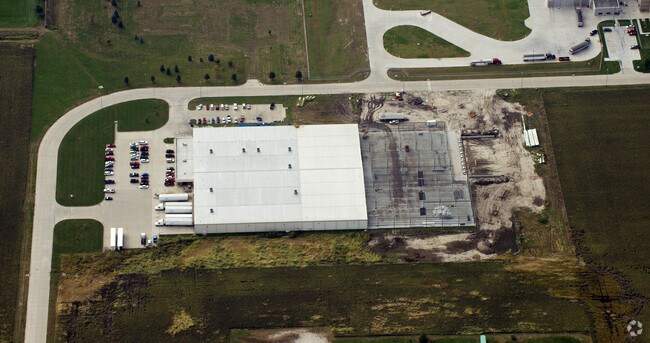
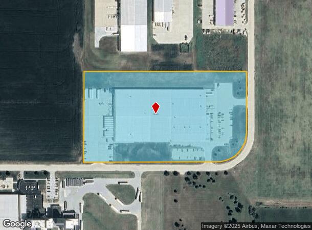
Property Record
2073 Rademakers Way, Fremont, NE 68025
NEARBY LISTINGS FOR SALE OR LEASE
-
-
View all Fremont listings for sale on LoopNet.com
Property Detail
2073 Rademakers Way
Fremont, NE
Christensen Business Park
270137019
CHRISTENSEN BUSINESS PARK LOT 7 & 8 BLK 1; MAP NUMBER: 2391-16-2-91145-001-0000
Manufacturinglight
Dodge
X
Nebraska
31155C0100D
7-8
2024
11.02 AC
2024
Nebraska Area
963900
Other Market Areas
60,000 SF
DEMOGRAPHICS near 2073 Rademakers Way
1 Mile
3 Mile
5 Mile
2024 Total Population
1,523
21,217
30,438
2029 Population
1,484
21,013
30,345
Pop Growth 2024-2029
(2.56%)
(0.96%)
(0.31%)
Average Age
38
39
40
2024 Total Households
586
8,432
12,105
HH Growth 2024-2029
(2.73%)
(0.94%)
(0.28%)
Median Household Inc
$66,000
$55,859
$61,844
Avg Household Size
2.50
2.40
2.40
2024 Avg HH Vehicles
2.00
2.00
2.00
Median Home Value
$194,117
$154,602
$173,419
Median Year Built
1979
1961
1968
Nearby Places
Map Layers
Map Styles
 Street
 Aerial
- Restaurants
- Banks
- Shops
- Fitness
- Groceries
Nearby Properties
Address
Land Use
TOTAL SIZE
Lot Size
Zoning
Address
Land Use
TOTAL SIZE
Lot Size
Zoning
7,504 SF
25.27 AC
INDUSTRIAL
Address
Land Use
TOTAL SIZE
Lot Size
Zoning
36,135 SF
8.89 AC
COMMERCIAL
Address
Land Use
TOTAL SIZE
Lot Size
Zoning
67,947 SF
10.67 AC
INDUSTRIAL
Address
Land Use
TOTAL SIZE
Lot Size
Zoning
59,307 SF
1.99 AC
COMMERCIAL
Address
Land Use
TOTAL SIZE
Lot Size
Zoning
99,964 SF
7.47 AC
INDUSTRIAL
Address
Land Use
TOTAL SIZE
Lot Size
Zoning
3,000 SF
4.37 AC
INDUSTRIAL
Address
Land Use
TOTAL SIZE
Lot Size
Zoning
65,589 SF
5.76 AC
COMMERCIAL
Address
Land Use
TOTAL SIZE
Lot Size
Zoning
21,384 SF
15 AC
INDUSTRIAL
Address
Land Use
TOTAL SIZE
Lot Size
Zoning
2,692 SF
19.27 AC
INDUSTRIAL
Address
Land Use
TOTAL SIZE
Lot Size
Zoning
4,952 SF
4.64 AC
MULTI-FAMI
Address
Land Use
TOTAL SIZE
Lot Size
Zoning
18,346 SF
2.94 AC
COMMERCIAL
Address
Land Use
TOTAL SIZE
Lot Size
Zoning
45,228 SF
2.01 AC
COMMERCIAL
Address
Land Use
TOTAL SIZE
Lot Size
Zoning
3,360 SF
4.99 AC
INDUSTRIAL
Address
Land Use
TOTAL SIZE
Lot Size
Zoning
43,560 SF
1.75 AC
COMMERCIAL
Address
Land Use
TOTAL SIZE
Lot Size
Zoning
59,225 SF
5.41 AC
COMMERCIAL
Address
Land Use
TOTAL SIZE
Lot Size
Zoning
22,928 SF
2.82 AC
INDUSTRIAL
Address
Land Use
TOTAL SIZE
Lot Size
Zoning
28,088 SF
10 AC
INDUSTRIAL
Address
Land Use
TOTAL SIZE
Lot Size
Zoning
16,360 SF
1.67 AC
COMMERCIAL
Address
Land Use
TOTAL SIZE
Lot Size
Zoning
11,810 SF
13.42 AC
COMMERCIAL
Address
Land Use
TOTAL SIZE
Lot Size
Zoning
3,510 SF
3.95 AC
INDUSTRIAL
Address
Land Use
TOTAL SIZE
Lot Size
Zoning
53,988 SF
5.07 AC
COMMERCIAL
Address
Land Use
TOTAL SIZE
Lot Size
Zoning
26,880 SF
5.11 AC
COMMERCIAL
Address
Land Use
TOTAL SIZE
Lot Size
Zoning
26,226 SF
2.06 AC
COMMERCIAL
Address
Land Use
TOTAL SIZE
Lot Size
Zoning
47,977 SF
3.92 AC
COMMERCIAL
Address
Land Use
TOTAL SIZE
Lot Size
Zoning
56,250 SF
8.09 AC
INDUSTRIAL
Address
Land Use
TOTAL SIZE
Lot Size
Zoning
52,830 SF
12.87 AC
INDUSTRIAL
Address
Land Use
TOTAL SIZE
Lot Size
Zoning
167,100 SF
8.92 AC
INDUSTRIAL
Address
Land Use
TOTAL SIZE
Lot Size
Zoning
14,956 SF
2.48 AC
COMMERCIAL
The World's #1 Commercial Real Estate Marketplace
Connect with us
© 2026 CoStar Group
The information above has been obtained from sources believed reliable. While we do not doubt its accuracy we have not verified it and make no guarantee, warranty or representation about it. It is your responsibility to independently confirm its accuracy and completeness. Any projections, opinions, assumptions, or estimates used are for example only and do not represent the current or future performance of the property. The value of this transaction to you depends on tax and other factors which should be evaluated by your tax, financial, and legal advisors. You and your advisors should conduct a careful, independent investigation of the property to determine to your satisfaction the suitability of the property for your needs.