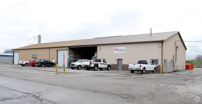
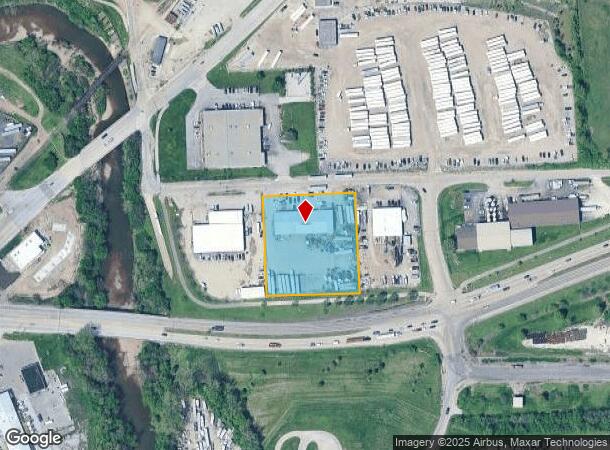
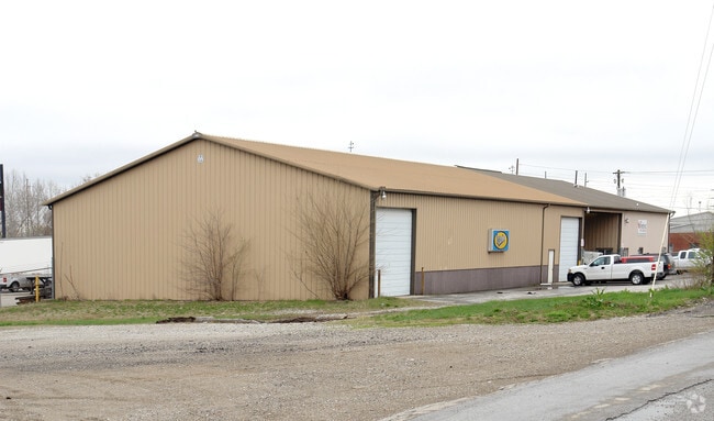
Property Record
2073 W Raymond St, Indianapolis, IN 46221
NEARBY LISTINGS FOR SALE OR LEASE
Property Detail
2073 W Raymond St
49-11-22-100-003.000-101
Section 22 Township 15 R 03
Warehouse
PT NW 1/4 S22 T15N R3E 450.1 E NW COR P.O.B. E280 S325 W265.25 WRLY14.75 N324.67 TO BEG 2.089 AC. (1.927 AC. TAXABLE)
AE
Marion
18097C0227G
Indiana
2023
2.09 AC
2024
White River Pkwy
358100
Indianapolis
9,240 SF
Indianapolis-Carmel-Anderson, IN
DEMOGRAPHICS near 2073 W Raymond St
1 Mile
3 Mile
5 Mile
2024 Total Population
3,267
59,137
220,067
2029 Population
3,301
59,693
221,088
Pop Growth 2024-2029
+ 1.04%
+ 0.94%
+ 0.46%
Average Age
35
35
35
2024 Total Households
1,124
23,166
91,134
HH Growth 2024-2029
+ 0.89%
+ 1.23%
+ 0.56%
Median Household Inc
$48,610
$51,299
$53,297
Avg Household Size
2.70
2.40
2.30
2024 Avg HH Vehicles
1.00
2.00
2.00
Median Home Value
$67,931
$112,715
$151,217
Median Year Built
1947
1951
1960
Nearby Places
Map Layers
Map Styles
 Street
 Aerial
- Restaurants
- Banks
- Shops
- Fitness
- Groceries
PUBLIC TRANSPORTATION
COMMUTER RAIL
DRIVE
WALK
Distance
7 min
3.1 mi
AIRPORT
Indianapolis International
DRIVE
WALK
Distance
Indianapolis International
21 min
10.2 mi
Nearby Properties
Address
Land Use
TOTAL SIZE
Lot Size
Zoning
Address
Land Use
TOTAL SIZE
Lot Size
Zoning
33.61 AC
ZO01
Address
Land Use
TOTAL SIZE
Lot Size
Zoning
1,381,492 SF
15.08 AC
ZO01
Address
Land Use
TOTAL SIZE
Lot Size
Zoning
546,391 SF
4.38 AC
ZO01
Address
Land Use
TOTAL SIZE
Lot Size
Zoning
5.59 AC
ZO01
Address
Land Use
TOTAL SIZE
Lot Size
Zoning
83,966 SF
2.30 AC
ZO01
Address
Land Use
TOTAL SIZE
Lot Size
Zoning
2,273 SF
1.52 AC
ZO01
Address
Land Use
TOTAL SIZE
Lot Size
Zoning
44,485 SF
0.76 AC
ZO01
Address
Land Use
TOTAL SIZE
Lot Size
Zoning
500,908 SF
10.36 AC
ZO01
Address
Land Use
TOTAL SIZE
Lot Size
Zoning
19,896 SF
32.59 AC
ZO01
Address
Land Use
TOTAL SIZE
Lot Size
Zoning
20,422 SF
0.42 AC
ZO01
Address
Land Use
TOTAL SIZE
Lot Size
Zoning
12.63 AC
ZO01
Address
Land Use
TOTAL SIZE
Lot Size
Zoning
123,373 SF
2.14 AC
ZO01
Address
Land Use
TOTAL SIZE
Lot Size
Zoning
6,000 SF
0.47 AC
ZO01
Address
Land Use
TOTAL SIZE
Lot Size
Zoning
40,205 SF
1.58 AC
Address
Land Use
TOTAL SIZE
Lot Size
Zoning
11,775 SF
0.44 AC
ZO01
Address
Land Use
TOTAL SIZE
Lot Size
Zoning
45,971 SF
0.78 AC
Address
Land Use
TOTAL SIZE
Lot Size
Zoning
73,803 SF
0.93 AC
Address
Land Use
TOTAL SIZE
Lot Size
Zoning
17,250 SF
0.29 AC
ZO01
Address
Land Use
TOTAL SIZE
Lot Size
Zoning
414,000 SF
1.64 AC
ZO01
Address
Land Use
TOTAL SIZE
Lot Size
Zoning
111,238 SF
0.06 AC
ZO01
Address
Land Use
TOTAL SIZE
Lot Size
Zoning
31,413 SF
3.91 AC
ZO01
Address
Land Use
TOTAL SIZE
Lot Size
Zoning
67,783 SF
44.97 AC
ZO01
Address
Land Use
TOTAL SIZE
Lot Size
Zoning
3.32 AC
ZO01
Address
Land Use
TOTAL SIZE
Lot Size
Zoning
1,281 SF
2.44 AC
ZO01
Address
Land Use
TOTAL SIZE
Lot Size
Zoning
25,918 SF
2.69 AC
ZO01
Address
Land Use
TOTAL SIZE
Lot Size
Zoning
11,150 SF
3.24 AC
ZO01
Address
Land Use
TOTAL SIZE
Lot Size
Zoning
19.74 AC
ZO01
Address
Land Use
TOTAL SIZE
Lot Size
Zoning
405,888 SF
19.56 AC
ZO01
Address
Land Use
TOTAL SIZE
Lot Size
Zoning
51,801 SF
0.06 AC
ZO01
Address
Land Use
TOTAL SIZE
Lot Size
Zoning
16,088 SF
0.94 AC
ZO01
The World's #1 Commercial Real Estate Marketplace
Connect with us
© 2025 CoStar Group
The information above has been obtained from sources believed reliable. While we do not doubt its accuracy we have not verified it and make no guarantee, warranty or representation about it. It is your responsibility to independently confirm its accuracy and completeness. Any projections, opinions, assumptions, or estimates used are for example only and do not represent the current or future performance of the property. The value of this transaction to you depends on tax and other factors which should be evaluated by your tax, financial, and legal advisors. You and your advisors should conduct a careful, independent investigation of the property to determine to your satisfaction the suitability of the property for your needs.