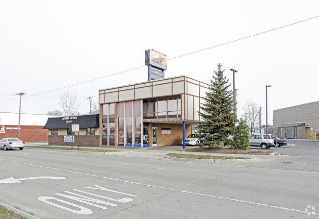
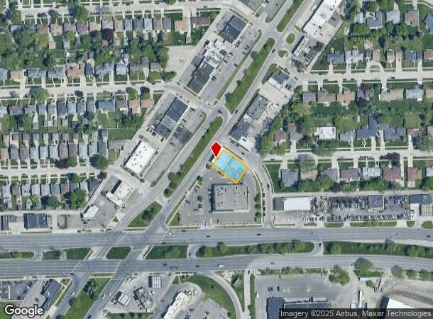
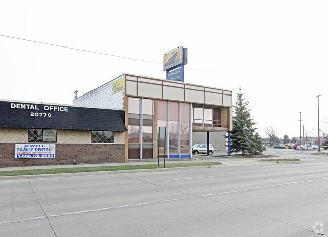
Property Record
20762 Kelly Rd, Eastpointe, MI 48021
NEARBY LISTINGS FOR SALE OR LEASE
Property Detail
20762 Kelly Rd
Detroit-Warren-Dearborn, MI
Obenauer-Barberlaing Cos Ridgemont Park
02-14-32-379-010
OBENAUER BARBER LAING CO'S RIDGEMONT PARK NO 1 LOTS 749 - 752, INCL 20 FT VAC ALLEY ADJ
Storebuilding
Macomb
X
Michigan
26163C0130F
749-752
2024
0.22 AC
2025
Macomb East
258500
Detroit
3,680 SF
DEMOGRAPHICS near 20762 Kelly Rd
1 Mile
3 Mile
5 Mile
2024 Total Population
19,328
170,842
348,789
2029 Population
18,940
169,340
345,978
Pop Growth 2024-2029
(2.01%)
(0.88%)
(0.81%)
Average Age
38
38
39
2024 Total Households
7,342
65,637
136,760
HH Growth 2024-2029
(2.12%)
(1.04%)
(0.93%)
Median Household Inc
$52,151
$52,045
$52,270
Avg Household Size
2.60
2.50
2.50
2024 Avg HH Vehicles
1.00
2.00
2.00
Median Home Value
$113,802
$123,358
$135,654
Median Year Built
1954
1954
1954
Nearby Places
Map Layers
Map Styles
 Street
 Aerial
- Restaurants
- Banks
- Shops
- Fitness
- Groceries
PUBLIC TRANSPORTATION
AIRPORT
Windsor International
DRIVE
WALK
Distance
Windsor International
44 min
23.3 mi
Detroit Metro Wayne County
DRIVE
WALK
Distance
Detroit Metro Wayne County
48 min
32.8 mi
Nearby Properties
Address
Land Use
TOTAL SIZE
Lot Size
Zoning
Address
Land Use
TOTAL SIZE
Lot Size
Zoning
1,034,990 SF
28.60 AC
Address
Land Use
TOTAL SIZE
Lot Size
Zoning
211,065 SF
8.84 AC
C.F
Address
Land Use
TOTAL SIZE
Lot Size
Zoning
575,081 SF
8.53 AC
R6
Address
Land Use
TOTAL SIZE
Lot Size
Zoning
182,866 SF
5.08 AC
PD
Address
Land Use
TOTAL SIZE
Lot Size
Zoning
89,970 SF
2.86 AC
RM-1
Address
Land Use
TOTAL SIZE
Lot Size
Zoning
192,387 SF
11.26 AC
CLD
Address
Land Use
TOTAL SIZE
Lot Size
Zoning
101,733 SF
1.10 AC
C-2
Address
Land Use
TOTAL SIZE
Lot Size
Zoning
103,069 SF
11.41 AC
B-3
Address
Land Use
TOTAL SIZE
Lot Size
Zoning
92,800 SF
6.71 AC
R-3
Address
Land Use
TOTAL SIZE
Lot Size
Zoning
105,354 SF
2.33 AC
B-3
Address
Land Use
TOTAL SIZE
Lot Size
Zoning
115,307 SF
7.01 AC
RM-1
Address
Land Use
TOTAL SIZE
Lot Size
Zoning
75,284 SF
0.87 AC
C
Address
Land Use
TOTAL SIZE
Lot Size
Zoning
167,589 SF
16.80 AC
B-3
Address
Land Use
TOTAL SIZE
Lot Size
Zoning
119,898 SF
14.65 AC
B-2
Address
Land Use
TOTAL SIZE
Lot Size
Zoning
136,270 SF
3.42 AC
LI
Address
Land Use
TOTAL SIZE
Lot Size
Zoning
91,739 SF
6.54 AC
B-2
Address
Land Use
TOTAL SIZE
Lot Size
Zoning
30,244 SF
2.06 AC
B-1
Address
Land Use
TOTAL SIZE
Lot Size
Zoning
28,300 SF
11.49 AC
I-1
Address
Land Use
TOTAL SIZE
Lot Size
Zoning
154,377 SF
8.07 AC
M-3
Address
Land Use
TOTAL SIZE
Lot Size
Zoning
131,120 SF
8.25 AC
M-2
Address
Land Use
TOTAL SIZE
Lot Size
Zoning
156,352 SF
2.72 AC
B-3
Address
Land Use
TOTAL SIZE
Lot Size
Zoning
26,068 SF
5.57 AC
B-2
Address
Land Use
TOTAL SIZE
Lot Size
Zoning
46,246 SF
3.19 AC
B-3
Address
Land Use
TOTAL SIZE
Lot Size
Zoning
131,960 SF
6.20 AC
M-2
Address
Land Use
TOTAL SIZE
Lot Size
Zoning
30,919 SF
0.86 AC
C
Address
Land Use
TOTAL SIZE
Lot Size
Zoning
36,417 SF
0.68 AC
B4
Address
Land Use
TOTAL SIZE
Lot Size
Zoning
141,023 SF
7.96 AC
MZ
Address
Land Use
TOTAL SIZE
Lot Size
Zoning
92,903 SF
1.70 AC
LI
Address
Land Use
TOTAL SIZE
Lot Size
Zoning
86,130 SF
5.20 AC
M-2
Address
Land Use
TOTAL SIZE
Lot Size
Zoning
80,320 SF
4.73 AC
RM-1
The World's #1 Commercial Real Estate Marketplace
Connect with us
© 2025 CoStar Group
The information above has been obtained from sources believed reliable. While we do not doubt its accuracy we have not verified it and make no guarantee, warranty or representation about it. It is your responsibility to independently confirm its accuracy and completeness. Any projections, opinions, assumptions, or estimates used are for example only and do not represent the current or future performance of the property. The value of this transaction to you depends on tax and other factors which should be evaluated by your tax, financial, and legal advisors. You and your advisors should conduct a careful, independent investigation of the property to determine to your satisfaction the suitability of the property for your needs.