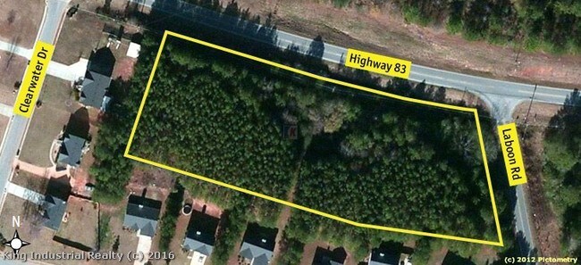
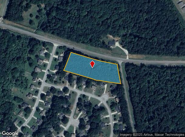
Property Record
1679 Highway 83, Monroe, GA 30655
NEARBY LISTINGS FOR SALE OR LEASE
Property Detail
1679 Highway 83
Atlanta-Sandy Springs-Roswell, GA
09120-County Nbhd / Spot
C165000000071000
2.71 AC
Commercialacreage
Walton
X
Georgia
13297C0145E
134
2024
2.71 AC
2024
Walton County
110702
Atlanta
DEMOGRAPHICS near 1679 Highway 83
1 Mile
3 Mile
5 Mile
2024 Total Population
1,840
10,517
27,787
2029 Population
2,148
12,272
32,356
Pop Growth 2024-2029
+ 16.74%
+ 16.69%
+ 16.44%
Average Age
40
39
39
2024 Total Households
673
3,879
10,367
HH Growth 2024-2029
+ 17.09%
+ 17.07%
+ 16.80%
Median Household Inc
$70,597
$50,299
$51,127
Avg Household Size
2.70
2.60
2.60
2024 Avg HH Vehicles
2.00
2.00
2.00
Median Home Value
$241,333
$222,102
$212,902
Median Year Built
2000
1987
1989
Nearby Places
Map Layers
Map Styles
 Street
 Aerial
- Restaurants
- Banks
- Shops
- Fitness
- Groceries
SALE & LEASE HISTORY
LISTING DATE
SALE/LEASE

Sep 24, 2016
For Sale
Nearby Properties
Address
Land Use
TOTAL SIZE
Lot Size
Zoning
Address
Land Use
TOTAL SIZE
Lot Size
Zoning
210,000 SF
36 AC
M1
Address
Land Use
TOTAL SIZE
Lot Size
Zoning
375,544 SF
128.40 AC
M1
Address
Land Use
TOTAL SIZE
Lot Size
Zoning
122,949 SF
28.37 AC
R1 P
Address
Land Use
TOTAL SIZE
Lot Size
Zoning
16,880 SF
55.23 AC
M1
Address
Land Use
TOTAL SIZE
Lot Size
Zoning
268,431 SF
14.74 AC
M1
Address
Land Use
TOTAL SIZE
Lot Size
Zoning
95,350 SF
48.62 AC
A1
Address
Land Use
TOTAL SIZE
Lot Size
Zoning
108,396 SF
40 AC
A1 R1
Address
Land Use
TOTAL SIZE
Lot Size
Zoning
58,980 SF
8.84 AC
PCD
Address
Land Use
TOTAL SIZE
Lot Size
Zoning
2,640 SF
64.81 AC
R1A
Address
Land Use
TOTAL SIZE
Lot Size
Zoning
70,400 SF
17 AC
M1
Address
Land Use
TOTAL SIZE
Lot Size
Zoning
140,800 SF
12.05 AC
I1
Address
Land Use
TOTAL SIZE
Lot Size
Zoning
7,200 SF
18 AC
A1
Address
Land Use
TOTAL SIZE
Lot Size
Zoning
159,604 SF
17.50 AC
M1
Address
Land Use
TOTAL SIZE
Lot Size
Zoning
37,600 SF
5.96 AC
B2
Address
Land Use
TOTAL SIZE
Lot Size
Zoning
3,912 SF
221.14 AC
MIX
Address
Land Use
TOTAL SIZE
Lot Size
Zoning
32,343 SF
4.11 AC
P
Address
Land Use
TOTAL SIZE
Lot Size
Zoning
3,040 SF
19.94 AC
M1
Address
Land Use
TOTAL SIZE
Lot Size
Zoning
26.64 AC
PCD
Address
Land Use
TOTAL SIZE
Lot Size
Zoning
10,000 SF
80.08 AC
M1
Address
Land Use
TOTAL SIZE
Lot Size
Zoning
23.89 AC
MHP
Address
Land Use
TOTAL SIZE
Lot Size
Zoning
225.97 AC
R1 P
Address
Land Use
TOTAL SIZE
Lot Size
Zoning
16,748 SF
25 AC
A2
Address
Land Use
TOTAL SIZE
Lot Size
Zoning
7,000 SF
3.83 AC
M1
Address
Land Use
TOTAL SIZE
Lot Size
Zoning
336 SF
23.43 AC
MH
Address
Land Use
TOTAL SIZE
Lot Size
Zoning
220.30 AC
A1
Address
Land Use
TOTAL SIZE
Lot Size
Zoning
5,600 SF
66.05 AC
M1
Address
Land Use
TOTAL SIZE
Lot Size
Zoning
9,463 SF
8.14 AC
R1
Address
Land Use
TOTAL SIZE
Lot Size
Zoning
140.98 AC
M1
Address
Land Use
TOTAL SIZE
Lot Size
Zoning
172.56 AC
A1
Address
Land Use
TOTAL SIZE
Lot Size
Zoning
154.96 AC
A1
The World's #1 Commercial Real Estate Marketplace
Connect with us
© 2025 CoStar Group
The information above has been obtained from sources believed reliable. While we do not doubt its accuracy we have not verified it and make no guarantee, warranty or representation about it. It is your responsibility to independently confirm its accuracy and completeness. Any projections, opinions, assumptions, or estimates used are for example only and do not represent the current or future performance of the property. The value of this transaction to you depends on tax and other factors which should be evaluated by your tax, financial, and legal advisors. You and your advisors should conduct a careful, independent investigation of the property to determine to your satisfaction the suitability of the property for your needs.