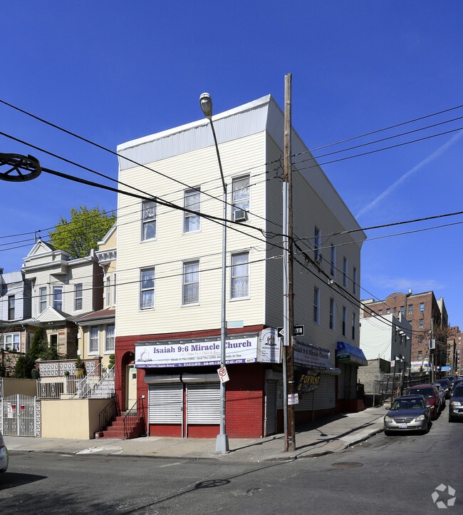
Property Record
2077 Ryer Ave, Bronx, NY 10457


Current Lease Availabilities
Property Detail
2077 Ryer Ave
03156-0057
Bronx
Apartment
New York
R8
57
B and X Area of moderate flood hazard, usually the area between the limits of the 100-year and 500-year floods.
0.19 AC
2025
Fordham Heights
2026
Westchester/So Connecticut
038100
New York-Jersey City-White Plains, NY-NJ
79,287 SF
NEARBY LISTINGS FOR SALE OR LEASE
DEMOGRAPHICS near 2077 Ryer Ave
1 mile
3 mile
5 mile
2025 Total Population
241,718
1,298,520
2,085,215
2030 Population
239,206
1,290,535
2,080,184
Pop Growth 2025-2030
(1.04%)
(0.61%)
(0.24%)
Average Age
37
39
40
2025 Total Households
79,160
462,617
766,674
HH Growth 2025-2030
(1.55%)
(0.73%)
(0.19%)
Median Household Inc
$40,286
$47,071
$52,768
Avg Household Size
2.80
2.60
2.50
2025 Avg HH Vehicles
.00
.00
1.00
Median Home Value
$327,753
$496,156
$578,917
Median Year Built
1948
1949
1953
Nearby Places
Map Layers
Map Styles
 Street
 Aerial
Layers
 Traffic
 Biking
Places
Listings with unknown addresses are not visible on the map
- Restaurants
- Banks
- Shops
- Fitness
- Groceries
PUBLIC TRANSPORTATION
COMMUTER RAIL
Tremont Station (Harlem Line - Metro-North Commuter Railroad Company (Metro-North))
Drive
Walk
Distance
Tremont Station (Harlem Line - Metro-North Commuter Railroad Company (Metro-North))
3 min
9 min
0.5 mi
Fordham Station (Harlem Line - Metro-North Commuter Railroad Company (Metro-North), New Haven Line - Metro-North Commuter Railroad Company (Metro-North))
Drive
Walk
Distance
Fordham Station (Harlem Line - Metro-North Commuter Railroad Company (Metro-North), New Haven Line - Metro-North Commuter Railroad Company (Metro-North))
3 min
18 min
0.9 mi
AIRPORT
LaGuardia
Drive
Walk
Distance
LaGuardia
21 min
10.6 mi
John F Kennedy International
Drive
Walk
Distance
John F Kennedy International
32 min
19.4 mi
Westchester County
Drive
Walk
Distance
Westchester County
38 min
23.4 mi
Freight Ports
NY - Red Hook Container Terminal
Drive
Walk
Distance
NY - Red Hook Container Terminal
34 min
18.8 mi
Nearby Properties
Address
Land Use
TOTAL SIZE
Lot Size
Zoning
Address
Land Use
TOTAL SIZE
Lot Size
Zoning
1,290,000 SF
14.56 AC
PARK
Address
Land Use
TOTAL SIZE
Lot Size
Zoning
3,533,539 SF
8.37 AC
R8
Address
Land Use
TOTAL SIZE
Lot Size
Zoning
1,299,700 SF
29.82 AC
R6
Address
Land Use
TOTAL SIZE
Lot Size
Zoning
1,743,584 SF
77.87 AC
R6
Address
Land Use
TOTAL SIZE
Lot Size
Zoning
1,427,393 SF
39.94 AC
R4
Address
Land Use
TOTAL SIZE
Lot Size
Zoning
1,651,267 SF
1.23 AC
R8
Address
Land Use
TOTAL SIZE
Lot Size
Zoning
481,172 SF
205.58 AC
PARK
Address
Land Use
TOTAL SIZE
Lot Size
Zoning
895,256 SF
8.32 AC
R7-1
Address
Land Use
TOTAL SIZE
Lot Size
Zoning
891,040 SF
5.63 AC
R8
Address
Land Use
TOTAL SIZE
Lot Size
Zoning
0.36 AC
R8
Address
Land Use
TOTAL SIZE
Lot Size
Zoning
1,311,800 SF
9.89 AC
C4-4
Address
Land Use
TOTAL SIZE
Lot Size
Zoning
1,237,424 SF
21.25 AC
R6
Address
Land Use
TOTAL SIZE
Lot Size
Zoning
204,200 SF
1.68 AC
R7-1
Address
Land Use
TOTAL SIZE
Lot Size
Zoning
42.68 AC
P1
Address
Land Use
TOTAL SIZE
Lot Size
Zoning
807,327 SF
0.60 AC
R8
Address
Land Use
TOTAL SIZE
Lot Size
Zoning
667,405 SF
5.51 AC
R6
Address
Land Use
TOTAL SIZE
Lot Size
Zoning
2,531,670 SF
17.15 AC
R7-2
Address
Land Use
TOTAL SIZE
Lot Size
Zoning
390,750 SF
265 AC
PARK
Address
Land Use
TOTAL SIZE
Lot Size
Zoning
598,815 SF
1.64 AC
R8
Address
Land Use
TOTAL SIZE
Lot Size
Zoning
39 AC
P1
Address
Land Use
TOTAL SIZE
Lot Size
Zoning
317,485 SF
1.57 AC
R8
Address
Land Use
TOTAL SIZE
Lot Size
Zoning
1,392,950 SF
19.67 AC
M2-1
Address
Land Use
TOTAL SIZE
Lot Size
Zoning
631,237 SF
30.93 AC
R5
Address
Land Use
TOTAL SIZE
Lot Size
Zoning
707,353 SF
29.34 AC
R6
Address
Land Use
TOTAL SIZE
Lot Size
Zoning
480,769 SF
1.21 AC
R8
Address
Land Use
TOTAL SIZE
Lot Size
Zoning
43.65 AC
PARK
Address
Land Use
TOTAL SIZE
Lot Size
Zoning
293,848 SF
2.98 AC
C8-3
Address
Land Use
TOTAL SIZE
Lot Size
Zoning
Address
Land Use
TOTAL SIZE
Lot Size
Zoning
851,821 SF
7.95 AC
R4
Address
Land Use
TOTAL SIZE
Lot Size
Zoning
271,029 SF
0.94 AC
C6-2
The World's #1 Commercial Real Estate Marketplace
Connect with us
© 2026 CoStar Group
The information above has been obtained from sources believed reliable. While we do not doubt its accuracy we have not verified it and make no guarantee, warranty or representation about it. It is your responsibility to independently confirm its accuracy and completeness. Any projections, opinions, assumptions, or estimates used are for example only and do not represent the current or future performance of the property. The value of this transaction to you depends on tax and other factors which should be evaluated by your tax, financial, and legal advisors. You and your advisors should conduct a careful, independent investigation of the property to determine to your satisfaction the suitability of the property for your needs.