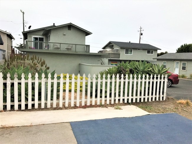
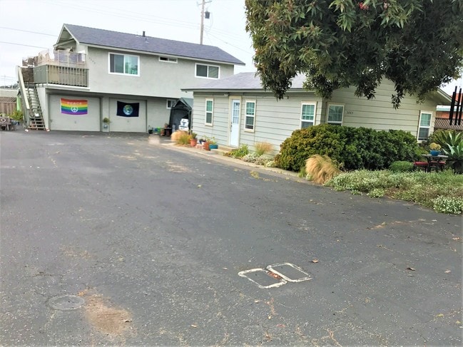
Property Record
2077 Sunset Ave, Morro Bay, CA 93442


Property Detail
2077 Sunset Ave
068-314-021
CY MB TR 52 BL 1 LTS 14 & 15
Multifamilydwelling
San Luis Obispo
20
California
B and X Area of moderate flood hazard, usually the area between the limits of the 100-year and 500-year floods.
14,15
2024
0.23 AC
2025
Morro Bay/Cayucos/Cambria
010505
San Luis Obispo/Paso Robles
3,571 SF
San Luis Obispo-Paso Robles, CA
NEARBY LISTINGS FOR SALE OR LEASE
DEMOGRAPHICS near 2077 Sunset Ave
1 mile
3 mile
5 mile
2025 Total Population
5,115
12,398
24,469
2030 Population
5,232
12,653
24,795
Pop Growth 2025-2030
+ 2.29%
+ 2.06%
+ 1.33%
Average Age
49
49
48
2025 Total Households
2,343
5,759
10,891
HH Growth 2025-2030
+ 2.13%
+ 1.88%
+ 1.31%
Median Household Inc
$100,689
$92,999
$95,692
Avg Household Size
2.10
2.10
2.20
2025 Avg HH Vehicles
2.00
2.00
2.00
Median Home Value
$830,838
$866,676
$843,988
Median Year Built
1978
1973
1974
Nearby Places
Map Layers
Map Styles
 Street
 Aerial
Layers
 Traffic
 Biking
Places
Listings with unknown addresses are not visible on the map
- Restaurants
- Banks
- Shops
- Fitness
- Groceries
PUBLIC TRANSPORTATION
AIRPORT
San Luis County Regional
Drive
Walk
Distance
San Luis County Regional
30 min
19.0 mi
Freight Ports
The Port of Hueneme
Drive
Walk
Distance
The Port of Hueneme
187 min
147.1 mi
SALE & LEASE HISTORY
LISTING DATE
SALE/LEASE

Jun 09, 2017
For Sale
Nearby Properties
Address
Land Use
TOTAL SIZE
Lot Size
Zoning
Address
Land Use
TOTAL SIZE
Lot Size
Zoning
90.32 AC
Address
Land Use
TOTAL SIZE
Lot Size
Zoning
49,089 SF
1.99 AC
CVS
Address
Land Use
TOTAL SIZE
Lot Size
Zoning
92,746 SF
5.27 AC
C2
Address
Land Use
TOTAL SIZE
Lot Size
Zoning
21,263 SF
0.43 AC
PD
Address
Land Use
TOTAL SIZE
Lot Size
Zoning
42,742 SF
4.47 AC
VSC
Address
Land Use
TOTAL SIZE
Lot Size
Zoning
47,906 SF
4.49 AC
C1
Address
Land Use
TOTAL SIZE
Lot Size
Zoning
19,329 SF
0.40 AC
C1
Address
Land Use
TOTAL SIZE
Lot Size
Zoning
0.40 AC
R4
Address
Land Use
TOTAL SIZE
Lot Size
Zoning
8,439 SF
0.28 AC
VSC
Address
Land Use
TOTAL SIZE
Lot Size
Zoning
26,037 SF
0.50 AC
PD
Address
Land Use
TOTAL SIZE
Lot Size
Zoning
6,588 SF
0.53 AC
60
Address
Land Use
TOTAL SIZE
Lot Size
Zoning
9,418 SF
0.37 AC
CVS
Address
Land Use
TOTAL SIZE
Lot Size
Zoning
21,672 SF
1 AC
R2
Address
Land Use
TOTAL SIZE
Lot Size
Zoning
11,285 SF
0.40 AC
VSC
Address
Land Use
TOTAL SIZE
Lot Size
Zoning
16,986 SF
1.72 AC
CVS
Address
Land Use
TOTAL SIZE
Lot Size
Zoning
3,684 SF
9.96 AC
R3
Address
Land Use
TOTAL SIZE
Lot Size
Zoning
6,948 SF
0.23 AC
Address
Land Use
TOTAL SIZE
Lot Size
Zoning
14,867 SF
0.69 AC
PD
Address
Land Use
TOTAL SIZE
Lot Size
Zoning
16,247 SF
0.40 AC
C1
Address
Land Use
TOTAL SIZE
Lot Size
Zoning
952 SF
350 AC
AG
Address
Land Use
TOTAL SIZE
Lot Size
Zoning
15,516 SF
0.80 AC
C1
Address
Land Use
TOTAL SIZE
Lot Size
Zoning
14,220 SF
1.03 AC
C1
Address
Land Use
TOTAL SIZE
Lot Size
Zoning
5,661 SF
0.54 AC
CVS
Address
Land Use
TOTAL SIZE
Lot Size
Zoning
9,160 SF
0.40 AC
CVS
Address
Land Use
TOTAL SIZE
Lot Size
Zoning
23,636 SF
2.57 AC
C1
Address
Land Use
TOTAL SIZE
Lot Size
Zoning
5,564 SF
0.14 AC
C1
Address
Land Use
TOTAL SIZE
Lot Size
Zoning
11,657 SF
0.34 AC
CR
Address
Land Use
TOTAL SIZE
Lot Size
Zoning
7,279 SF
1.12 AC
CT
Address
Land Use
TOTAL SIZE
Lot Size
Zoning
17,200 SF
0.40 AC
R2PD
Address
Land Use
TOTAL SIZE
Lot Size
Zoning
21,000 SF
3.16 AC
The World's #1 Commercial Real Estate Marketplace
Connect with us
© 2026 CoStar Group
The information above has been obtained from sources believed reliable. While we do not doubt its accuracy we have not verified it and make no guarantee, warranty or representation about it. It is your responsibility to independently confirm its accuracy and completeness. Any projections, opinions, assumptions, or estimates used are for example only and do not represent the current or future performance of the property. The value of this transaction to you depends on tax and other factors which should be evaluated by your tax, financial, and legal advisors. You and your advisors should conduct a careful, independent investigation of the property to determine to your satisfaction the suitability of the property for your needs.