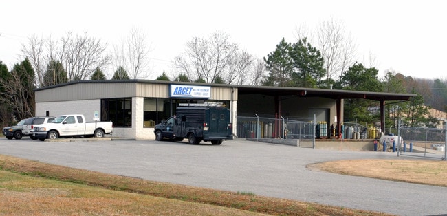
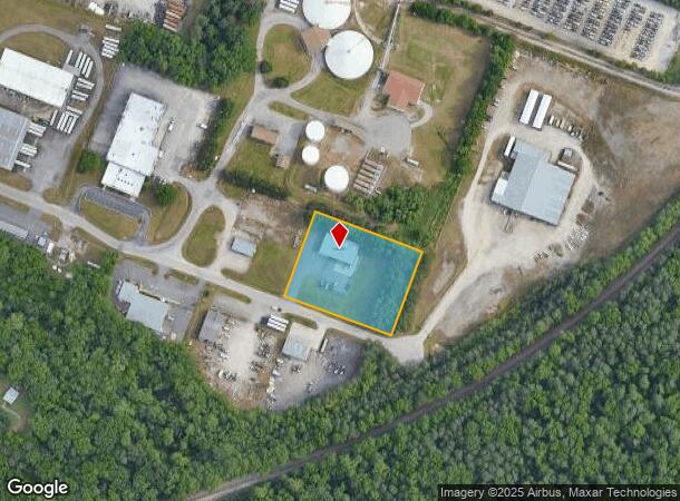
Property Record
2078 E Whitehill Rd, Prince George, VA 23875
NEARBY LISTINGS FOR SALE OR LEASE
Property Detail
2078 E Whitehill Rd
22B-03-00-008-0
LT:3 BK: SEC:2; SUB:EAST WHITEHILL INDUS PARK; ACRES:1.8365;
Warehouse
Prince George
AE
Virginia
51149C0155C
3
2024
1.84 AC
2025
Prince George
850100
Richmond VA
3,000 SF
Richmond, VA
DEMOGRAPHICS near 2078 E Whitehill Rd
1 mile
3 mile
5 mile
2024 Total Population
7,080
42,855
103,555
2029 Population
7,152
43,290
104,796
Pop Growth 2024-2029
+ 1.02%
+ 1.02%
+ 1.20%
Average Age
27
37
38
2024 Total Households
908
15,844
37,934
HH Growth 2024-2029
+ 0.99%
+ 0.83%
+ 1.04%
Median Household Inc
$26,862
$55,421
$54,317
Avg Household Size
2.50
2.30
2.30
2024 Avg HH Vehicles
1.00
2.00
2.00
Median Home Value
$139,156
$179,528
$168,372
Median Year Built
1977
1972
1973
Nearby Places
Map Layers
Map Styles
 Street
 Aerial
Transit
 Traffic
 Biking
Places
Listings with unknown addresses are not visible on the map
- Restaurants
- Banks
- Shops
- Fitness
- Groceries
PUBLIC TRANSPORTATION
COMMUTER RAIL
Drive
Walk
Distance
9 min
4.6 mi
AIRPORT
Richmond International
Drive
Walk
Distance
Richmond International
37 min
26.7 mi
Freight Ports
Virginia Port Authority - Richmond
Drive
Walk
Distance
Virginia Port Authority - Richmond
30 min
19.4 mi
Nearby Properties
Address
Land Use
TOTAL SIZE
Lot Size
Zoning
Address
Land Use
TOTAL SIZE
Lot Size
Zoning
4,762.27 AC
Address
Land Use
TOTAL SIZE
Lot Size
Zoning
500 SF
390.12 AC
R7 - SINGL
Address
Land Use
TOTAL SIZE
Lot Size
Zoning
28.17 AC
PUD
Address
Land Use
TOTAL SIZE
Lot Size
Zoning
15,435 SF
13.51 AC
11
Address
Land Use
TOTAL SIZE
Lot Size
Zoning
498.93 AC
Address
Land Use
TOTAL SIZE
Lot Size
Zoning
209,515 SF
21.20 AC
B3
Address
Land Use
TOTAL SIZE
Lot Size
Zoning
188,368 SF
18.96 AC
B1
Address
Land Use
TOTAL SIZE
Lot Size
Zoning
119,151 SF
3.10 AC
M-1
Address
Land Use
TOTAL SIZE
Lot Size
Zoning
130,698 SF
10.78 AC
PUD
Address
Land Use
TOTAL SIZE
Lot Size
Zoning
223,211 SF
19.99 AC
B3
Address
Land Use
TOTAL SIZE
Lot Size
Zoning
57,011 SF
4.45 AC
BB
Address
Land Use
TOTAL SIZE
Lot Size
Zoning
89,138 SF
6.45 AC
PUD
Address
Land Use
TOTAL SIZE
Lot Size
Zoning
407,650 SF
136.67 AC
M-2
Address
Land Use
TOTAL SIZE
Lot Size
Zoning
16 AC
R3
Address
Land Use
TOTAL SIZE
Lot Size
Zoning
129,600 SF
12.21 AC
PUD
Address
Land Use
TOTAL SIZE
Lot Size
Zoning
56,701 SF
7.53 AC
R4
Address
Land Use
TOTAL SIZE
Lot Size
Zoning
186,558 SF
19.06 AC
11
Address
Land Use
TOTAL SIZE
Lot Size
Zoning
128,848 SF
13.24 AC
B3
Address
Land Use
TOTAL SIZE
Lot Size
Zoning
92,701 SF
2.87 AC
B1
Address
Land Use
TOTAL SIZE
Lot Size
Zoning
89,734 SF
2.85 AC
B1
Address
Land Use
TOTAL SIZE
Lot Size
Zoning
86,387 SF
10.91 AC
B3
Address
Land Use
TOTAL SIZE
Lot Size
Zoning
6,284 SF
14.29 AC
11
Address
Land Use
TOTAL SIZE
Lot Size
Zoning
67,161 SF
3.06 AC
B3
Address
Land Use
TOTAL SIZE
Lot Size
Zoning
3,632 SF
11.30 AC
M-2
Address
Land Use
TOTAL SIZE
Lot Size
Zoning
37,809 SF
150 AC
R7 - SINGL
Address
Land Use
TOTAL SIZE
Lot Size
Zoning
68,438 SF
1.93 AC
Address
Land Use
TOTAL SIZE
Lot Size
Zoning
86,204 SF
54.43 AC
Address
Land Use
TOTAL SIZE
Lot Size
Zoning
140,340 SF
13.08 AC
B3
Address
Land Use
TOTAL SIZE
Lot Size
Zoning
182,760 SF
10.50 AC
R-4
Address
Land Use
TOTAL SIZE
Lot Size
Zoning
97,419 SF
20 AC
R1
The World's #1 Commercial Real Estate Marketplace
Connect with us
© 2026 CoStar Group
The information above has been obtained from sources believed reliable. While we do not doubt its accuracy we have not verified it and make no guarantee, warranty or representation about it. It is your responsibility to independently confirm its accuracy and completeness. Any projections, opinions, assumptions, or estimates used are for example only and do not represent the current or future performance of the property. The value of this transaction to you depends on tax and other factors which should be evaluated by your tax, financial, and legal advisors. You and your advisors should conduct a careful, independent investigation of the property to determine to your satisfaction the suitability of the property for your needs.