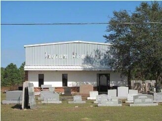
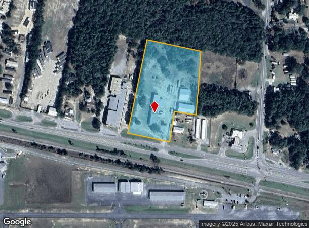
Property Record
2078 Us Highway 90 W, Defuniak Springs, FL 32433
NEARBY LISTINGS FOR SALE OR LEASE
Property Detail
2078 Us Highway 90 W
28-3N-19-19000-008-0000
COM SW/C OF SE1/4 OF SW1/4 SEC 21 THENCE ALONG S LINE OF SEC 21, N 88 DEG 3825E 406.57FT TO POB RUN N 10 DEG 5629E 361.37FT RUN S 79 DEG 0331E 363.80FT RUN S 03 DEG 0941W 436.40FT THENCE N 82 DEG 43 41W 148.61FT RUN S 08 DEG 0110W 173.18FT TO NORTHER
Lightindustrial
Walton
X
Florida
12131C0260G
4.47 AC
2025
Florida Panhandle Area
2025
Other Market Areas
950303
Crestview-Fort Walton Beach-Destin, FL
18,460 SF
DEMOGRAPHICS near 2078 Us Highway 90 W
1 Mile
3 Mile
5 Mile
2024 Total Population
1,147
7,415
12,349
2029 Population
1,372
8,895
14,818
Pop Growth 2024-2029
+ 19.62%
+ 19.96%
+ 19.99%
Average Age
35
38
39
2024 Total Households
414
2,638
4,144
HH Growth 2024-2029
+ 19.57%
+ 19.94%
+ 19.96%
Median Household Inc
$43,593
$39,070
$39,731
Avg Household Size
2.70
2.50
2.50
2024 Avg HH Vehicles
2.00
2.00
2.00
Median Home Value
$128,906
$110,152
$92,904
Median Year Built
1987
1990
1991
Nearby Places
Map Layers
Map Styles
 Street
 Aerial
- Restaurants
- Banks
- Shops
- Fitness
- Groceries
PUBLIC TRANSPORTATION
AIRPORT
Eglin AFB/Destin-Ft Walton Beach
DRIVE
WALK
Distance
Eglin AFB/Destin-Ft Walton Beach
64 min
35.4 mi
Freight Ports
Port of Panama City
DRIVE
WALK
Distance
Port of Panama City
82 min
59.6 mi
Nearby Properties
Address
Land Use
TOTAL SIZE
Lot Size
Zoning
Address
Land Use
TOTAL SIZE
Lot Size
Zoning
461,058 SF
45.55 AC
Address
Land Use
TOTAL SIZE
Lot Size
Zoning
174,929 SF
9.32 AC
HD1
Address
Land Use
TOTAL SIZE
Lot Size
Zoning
126,838 SF
27.27 AC
Address
Land Use
TOTAL SIZE
Lot Size
Zoning
96,057 SF
10.37 AC
W END
Address
Land Use
TOTAL SIZE
Lot Size
Zoning
160,339 SF
19.76 AC
3310
Address
Land Use
TOTAL SIZE
Lot Size
Zoning
81,976 SF
315 AC
Address
Land Use
TOTAL SIZE
Lot Size
Zoning
37,731 SF
15.96 AC
Address
Land Use
TOTAL SIZE
Lot Size
Zoning
53,201 SF
14.45 AC
Address
Land Use
TOTAL SIZE
Lot Size
Zoning
101,840 SF
11.04 AC
3310
Address
Land Use
TOTAL SIZE
Lot Size
Zoning
10,655 SF
163.72 AC
MUNI
Address
Land Use
TOTAL SIZE
Lot Size
Zoning
109,921 SF
2.25 AC
Address
Land Use
TOTAL SIZE
Lot Size
Zoning
20,570 SF
13.64 AC
Address
Land Use
TOTAL SIZE
Lot Size
Zoning
68,153 SF
9.65 AC
3310
Address
Land Use
TOTAL SIZE
Lot Size
Zoning
15,264 SF
3.24 AC
3310
Address
Land Use
TOTAL SIZE
Lot Size
Zoning
48,394 SF
8.79 AC
3310
Address
Land Use
TOTAL SIZE
Lot Size
Zoning
104,680 SF
10 AC
Address
Land Use
TOTAL SIZE
Lot Size
Zoning
32,375 SF
6.46 AC
HWY90
Address
Land Use
TOTAL SIZE
Lot Size
Zoning
3,987 SF
104.01 AC
LKJUNP
Address
Land Use
TOTAL SIZE
Lot Size
Zoning
17,310 SF
13.26 AC
3310
Address
Land Use
TOTAL SIZE
Lot Size
Zoning
35,967 SF
4.11 AC
Address
Land Use
TOTAL SIZE
Lot Size
Zoning
14,525 SF
0.90 AC
HWY90
Address
Land Use
TOTAL SIZE
Lot Size
Zoning
17,376 SF
79.90 AC
HD1
Address
Land Use
TOTAL SIZE
Lot Size
Zoning
24,662 SF
2.04 AC
Address
Land Use
TOTAL SIZE
Lot Size
Zoning
35,050 SF
3.98 AC
MUNI
Address
Land Use
TOTAL SIZE
Lot Size
Zoning
37,138 SF
8.10 AC
HWY90
Address
Land Use
TOTAL SIZE
Lot Size
Zoning
55,016 SF
4.44 AC
Address
Land Use
TOTAL SIZE
Lot Size
Zoning
34,875 SF
1.84 AC
HWY90
Address
Land Use
TOTAL SIZE
Lot Size
Zoning
12,951 SF
3.49 AC
UR
Address
Land Use
TOTAL SIZE
Lot Size
Zoning
18,856 SF
1.87 AC
3310
Address
Land Use
TOTAL SIZE
Lot Size
Zoning
41,424 SF
8.44 AC
PF
The World's #1 Commercial Real Estate Marketplace
Connect with us
© 2025 CoStar Group
The information above has been obtained from sources believed reliable. While we do not doubt its accuracy we have not verified it and make no guarantee, warranty or representation about it. It is your responsibility to independently confirm its accuracy and completeness. Any projections, opinions, assumptions, or estimates used are for example only and do not represent the current or future performance of the property. The value of this transaction to you depends on tax and other factors which should be evaluated by your tax, financial, and legal advisors. You and your advisors should conduct a careful, independent investigation of the property to determine to your satisfaction the suitability of the property for your needs.