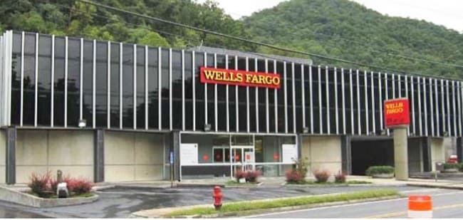
Property Record
20786 Riverside Dr, Grundy, VA 24614

NEARBY LISTINGS FOR SALE OR LEASE
-
-
View all Grundy listings for sale on LoopNet.com
Property Detail
20786 Riverside Dr
Financialbuilding
WATKINS BRANCH WATKINS 59 PT360 59 & AC 1 LOT & PART LOT
X
Buchanan
51027C0188E
Virginia
2024
0.53 AC
2024
Virginia Regional
010100
Other Market Areas
11,880 SF
2HH182024 FENLG B
DEMOGRAPHICS near 20786 Riverside Dr
1 Mile
3 Mile
5 Mile
2024 Total Population
376
2,009
4,596
2029 Population
346
1,861
4,294
Pop Growth 2024-2029
(7.98%)
(7.37%)
(6.57%)
Average Age
45
44
45
2024 Total Households
178
878
1,972
HH Growth 2024-2029
(7.30%)
(7.18%)
(6.24%)
Median Household Inc
$56,666
$54,625
$47,448
Avg Household Size
2.10
2.10
2.20
2024 Avg HH Vehicles
2.00
2.00
2.00
Median Home Value
$147,761
$132,996
$112,218
Median Year Built
1978
1974
1975
Nearby Places
Map Layers
Map Styles
 Street
 Aerial
- Restaurants
- Banks
- Shops
- Fitness
- Groceries
SALE & LEASE HISTORY
LISTING DATE
SALE/LEASE

May 02, 2024
For Sale
Nearby Properties
Address
Land Use
TOTAL SIZE
Lot Size
Zoning
Address
Land Use
TOTAL SIZE
Lot Size
Zoning
49,410 SF
5.81 AC
Address
Land Use
TOTAL SIZE
Lot Size
Zoning
Address
Land Use
TOTAL SIZE
Lot Size
Zoning
21,576 SF
0.51 AC
Address
Land Use
TOTAL SIZE
Lot Size
Zoning
37,912 SF
1.44 AC
Address
Land Use
TOTAL SIZE
Lot Size
Zoning
10,320 SF
0.50 AC
Address
Land Use
TOTAL SIZE
Lot Size
Zoning
5.80 AC
Address
Land Use
TOTAL SIZE
Lot Size
Zoning
7,200 SF
1.38 AC
Address
Land Use
TOTAL SIZE
Lot Size
Zoning
1.29 AC
Address
Land Use
TOTAL SIZE
Lot Size
Zoning
5,033 SF
1.85 AC
Address
Land Use
TOTAL SIZE
Lot Size
Zoning
112 SF
3.36 AC
Address
Land Use
TOTAL SIZE
Lot Size
Zoning
6,845 SF
1.49 AC
Address
Land Use
TOTAL SIZE
Lot Size
Zoning
20,838 SF
1.04 AC
Address
Land Use
TOTAL SIZE
Lot Size
Zoning
6,920 SF
1.85 AC
Address
Land Use
TOTAL SIZE
Lot Size
Zoning
18,200 SF
2.84 AC
Address
Land Use
TOTAL SIZE
Lot Size
Zoning
2.47 AC
Address
Land Use
TOTAL SIZE
Lot Size
Zoning
8,184 SF
1.43 AC
Address
Land Use
TOTAL SIZE
Lot Size
Zoning
7,360 SF
0.82 AC
Address
Land Use
TOTAL SIZE
Lot Size
Zoning
2,244 SF
0.10 AC
Address
Land Use
TOTAL SIZE
Lot Size
Zoning
0.76 AC
Address
Land Use
TOTAL SIZE
Lot Size
Zoning
9,595 SF
1.51 AC
Address
Land Use
TOTAL SIZE
Lot Size
Zoning
3,204 SF
0.95 AC
Address
Land Use
TOTAL SIZE
Lot Size
Zoning
7,210 SF
3.10 AC
Address
Land Use
TOTAL SIZE
Lot Size
Zoning
0.83 AC
Address
Land Use
TOTAL SIZE
Lot Size
Zoning
67,332 SF
4 AC
Address
Land Use
TOTAL SIZE
Lot Size
Zoning
0.06 AC
Address
Land Use
TOTAL SIZE
Lot Size
Zoning
10,352 SF
0.46 AC
Address
Land Use
TOTAL SIZE
Lot Size
Zoning
7,536 SF
45 AC
Address
Land Use
TOTAL SIZE
Lot Size
Zoning
The World's #1 Commercial Real Estate Marketplace
Connect with us
© 2025 CoStar Group
The information above has been obtained from sources believed reliable. While we do not doubt its accuracy we have not verified it and make no guarantee, warranty or representation about it. It is your responsibility to independently confirm its accuracy and completeness. Any projections, opinions, assumptions, or estimates used are for example only and do not represent the current or future performance of the property. The value of this transaction to you depends on tax and other factors which should be evaluated by your tax, financial, and legal advisors. You and your advisors should conduct a careful, independent investigation of the property to determine to your satisfaction the suitability of the property for your needs.