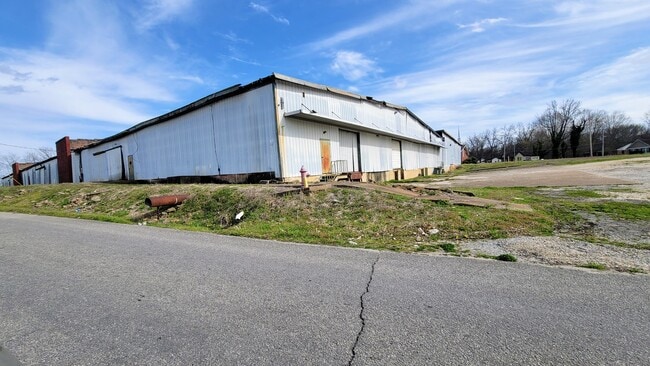
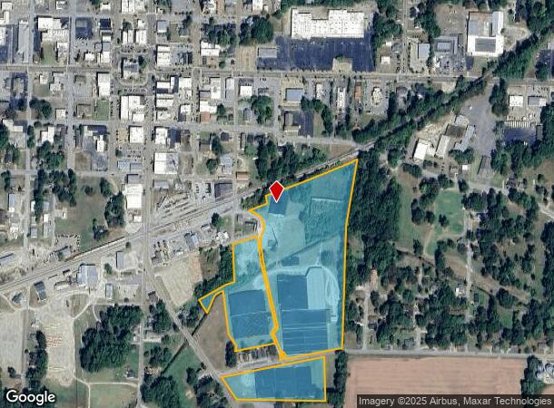
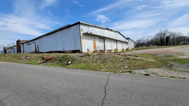
Property Record
208 E Powell St, Brownsville, TN 38012
NEARBY LISTINGS FOR SALE OR LEASE
Property Detail
208 E Powell St
075E-E-001.00
FEDERAL COMPRESS
Warehouse
Haywood
AE
Tennessee
47075C0234D
23.90 AC
0
Tennessee West Area
2025
Other Market Areas
930400
Brownsville, TN
171,906 SF
DEMOGRAPHICS near 208 E Powell St
1 Mile
3 Mile
5 Mile
2024 Total Population
5,109
10,408
11,508
2029 Population
5,040
10,208
11,283
Pop Growth 2024-2029
(1.35%)
(1.92%)
(1.96%)
Average Age
40
40
40
2024 Total Households
2,167
4,341
4,774
HH Growth 2024-2029
(1.29%)
(1.87%)
(1.86%)
Median Household Inc
$37,256
$39,297
$38,870
Avg Household Size
2.30
2.30
2.40
2024 Avg HH Vehicles
2.00
2.00
2.00
Median Home Value
$101,287
$126,601
$128,373
Median Year Built
1974
1974
1974
Nearby Places
- Restaurants
- Banks
- Shops
- Fitness
- Groceries
SALE & LEASE HISTORY
LISTING DATE
SALE/LEASE

Apr 06, 2022
For Sale
Nearby Properties
Address
Land Use
TOTAL SIZE
Lot Size
Zoning
Address
Land Use
TOTAL SIZE
Lot Size
Zoning
201,180 SF
25.03 AC
GI
Address
Land Use
TOTAL SIZE
Lot Size
Zoning
74,755 SF
8.42 AC
GC
Address
Land Use
TOTAL SIZE
Lot Size
Zoning
70,400 SF
GI
Address
Land Use
TOTAL SIZE
Lot Size
Zoning
4,956 SF
27.37 AC
MPO
Address
Land Use
TOTAL SIZE
Lot Size
Zoning
481,848 SF
48.04 AC
GI
Address
Land Use
TOTAL SIZE
Lot Size
Zoning
4,956 SF
4.23 AC
MPO
Address
Land Use
TOTAL SIZE
Lot Size
Zoning
371,800 SF
62.32 AC
Address
Land Use
TOTAL SIZE
Lot Size
Zoning
157,481 SF
22.22 AC
GC
Address
Land Use
TOTAL SIZE
Lot Size
Zoning
101,000 SF
6 AC
GI
Address
Land Use
TOTAL SIZE
Lot Size
Zoning
15,958 SF
10 AC
GC
Address
Land Use
TOTAL SIZE
Lot Size
Zoning
201,497 SF
44.47 AC
GI
Address
Land Use
TOTAL SIZE
Lot Size
Zoning
6,253 SF
FR
Address
Land Use
TOTAL SIZE
Lot Size
Zoning
292,450 SF
29.50 AC
RI
Address
Land Use
TOTAL SIZE
Lot Size
Zoning
2,800 SF
32.67 AC
FAR
Address
Land Use
TOTAL SIZE
Lot Size
Zoning
136,251 SF
16.63 AC
GI
Address
Land Use
TOTAL SIZE
Lot Size
Zoning
8,280 SF
12 AC
Address
Land Use
TOTAL SIZE
Lot Size
Zoning
10,033 SF
2.31 AC
R1
Address
Land Use
TOTAL SIZE
Lot Size
Zoning
13,420 SF
8.50 AC
SCC
Address
Land Use
TOTAL SIZE
Lot Size
Zoning
24,698 SF
0.43 AC
CB
Address
Land Use
TOTAL SIZE
Lot Size
Zoning
330.75 AC
GI
Address
Land Use
TOTAL SIZE
Lot Size
Zoning
104,000 SF
6 AC
GI
Address
Land Use
TOTAL SIZE
Lot Size
Zoning
14,055 SF
199.24 AC
CB
Address
Land Use
TOTAL SIZE
Lot Size
Zoning
90,480 SF
35.92 AC
GI
Address
Land Use
TOTAL SIZE
Lot Size
Zoning
201.50 AC
I2
Address
Land Use
TOTAL SIZE
Lot Size
Zoning
63,270 SF
9.92 AC
GC
Address
Land Use
TOTAL SIZE
Lot Size
Zoning
178,169 SF
7.22 AC
R3
Address
Land Use
TOTAL SIZE
Lot Size
Zoning
2,927 SF
4 AC
R3
Address
Land Use
TOTAL SIZE
Lot Size
Zoning
7,200 SF
5 AC
R3
Address
Land Use
TOTAL SIZE
Lot Size
Zoning
4,344 SF
5.35 AC
R3
The World's #1 Commercial Real Estate Marketplace
Connect with us
© 2025 CoStar Group
The information above has been obtained from sources believed reliable. While we do not doubt its accuracy we have not verified it and make no guarantee, warranty or representation about it. It is your responsibility to independently confirm its accuracy and completeness. Any projections, opinions, assumptions, or estimates used are for example only and do not represent the current or future performance of the property. The value of this transaction to you depends on tax and other factors which should be evaluated by your tax, financial, and legal advisors. You and your advisors should conduct a careful, independent investigation of the property to determine to your satisfaction the suitability of the property for your needs.