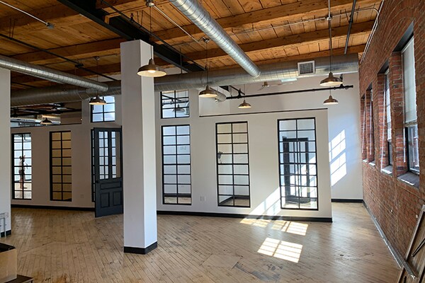
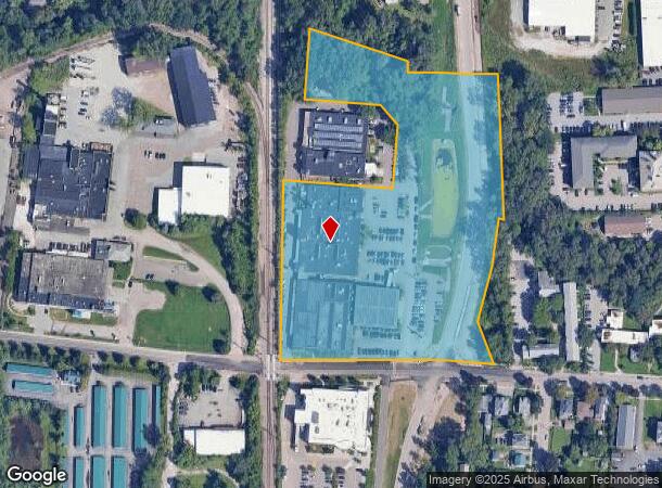
Property Record
208 Flynn Ave, Burlington, VT 05401
NEARBY LISTINGS FOR SALE OR LEASE
Property Detail
208 Flynn Ave
(035) 057-1-003-000
GRAVIS SELECT DESIGN DAVID`S CAFE HOWARD
Industrialgeneral
Chittenden
X
Vermont
50007C0254D
9 AC
2024
South End
2024
Other Market Areas
001000
Burlington-South Burlington, VT
DEMOGRAPHICS near 208 Flynn Ave
1 Mile
3 Mile
5 Mile
2024 Total Population
8,608
56,197
81,687
2029 Population
8,740
56,972
82,817
Pop Growth 2024-2029
+ 1.53%
+ 1.38%
+ 1.38%
Average Age
39
36
37
2024 Total Households
3,956
23,331
33,478
HH Growth 2024-2029
+ 1.62%
+ 1.45%
+ 1.49%
Median Household Inc
$92,729
$70,806
$74,500
Avg Household Size
2.10
2.10
2.10
2024 Avg HH Vehicles
2.00
1.00
2.00
Median Home Value
$453,015
$388,819
$385,299
Median Year Built
1966
1971
1973
Nearby Places
Map Layers
Map Styles
 Street
 Aerial
- Restaurants
- Banks
- Shops
- Fitness
- Groceries
PUBLIC TRANSPORTATION
COMMUTER RAIL
Btn (Ethan Allen Express - Amtrak)
DRIVE
WALK
Distance
Btn (Ethan Allen Express - Amtrak)
6 min
1.9 mi
AIRPORT
Patrick Leahy Burlington International
DRIVE
WALK
Distance
Patrick Leahy Burlington International
20 min
8.3 mi
Plattsburgh International
DRIVE
WALK
Distance
Plattsburgh International
73 min
37.7 mi
Freight Ports
Montreal
DRIVE
WALK
Distance
Montreal
132 min
101.0 mi
SALE & LEASE HISTORY
LISTING DATE
SALE/LEASE

Oct 26, 2022
For Lease
Aug 17, 2017
For Sale
Nearby Properties
Address
Land Use
TOTAL SIZE
Lot Size
Zoning
Address
Land Use
TOTAL SIZE
Lot Size
Zoning
2,542,351 SF
34.82 AC
I
Address
Land Use
TOTAL SIZE
Lot Size
Zoning
168,175 SF
I
Address
Land Use
TOTAL SIZE
Lot Size
Zoning
2.96 AC
I
Address
Land Use
TOTAL SIZE
Lot Size
Zoning
12.26 AC
I
Address
Land Use
TOTAL SIZE
Lot Size
Zoning
Address
Land Use
TOTAL SIZE
Lot Size
Zoning
232,277 SF
17.20 AC
I
Address
Land Use
TOTAL SIZE
Lot Size
Zoning
Address
Land Use
TOTAL SIZE
Lot Size
Zoning
Address
Land Use
TOTAL SIZE
Lot Size
Zoning
167,016 SF
2.30 AC
I
Address
Land Use
TOTAL SIZE
Lot Size
Zoning
32.43 AC
I
Address
Land Use
TOTAL SIZE
Lot Size
Zoning
1.70 AC
FD6
Address
Land Use
TOTAL SIZE
Lot Size
Zoning
19.86 AC
I
Address
Land Use
TOTAL SIZE
Lot Size
Zoning
98,123 SF
I
Address
Land Use
TOTAL SIZE
Lot Size
Zoning
20.87 AC
RL
Address
Land Use
TOTAL SIZE
Lot Size
Zoning
Address
Land Use
TOTAL SIZE
Lot Size
Zoning
157,081 SF
I
Address
Land Use
TOTAL SIZE
Lot Size
Zoning
1.16 AC
FD6
Address
Land Use
TOTAL SIZE
Lot Size
Zoning
181,068 SF
I
Address
Land Use
TOTAL SIZE
Lot Size
Zoning
140,910 SF
2.72 AC
I
Address
Land Use
TOTAL SIZE
Lot Size
Zoning
2.06 AC
FD6
Address
Land Use
TOTAL SIZE
Lot Size
Zoning
11.82 AC
ELM
Address
Land Use
TOTAL SIZE
Lot Size
Zoning
Address
Land Use
TOTAL SIZE
Lot Size
Zoning
216,574 SF
15.36 AC
Address
Land Use
TOTAL SIZE
Lot Size
Zoning
6.50 AC
I
Address
Land Use
TOTAL SIZE
Lot Size
Zoning
68,321 SF
4.60 AC
I
Address
Land Use
TOTAL SIZE
Lot Size
Zoning
Address
Land Use
TOTAL SIZE
Lot Size
Zoning
119,561 SF
1.86 AC
FD5
Address
Land Use
TOTAL SIZE
Lot Size
Zoning
8,680 SF
45.56 AC
EAE
Address
Land Use
TOTAL SIZE
Lot Size
Zoning
140.43 AC
I
Address
Land Use
TOTAL SIZE
Lot Size
Zoning
107,141 SF
I
The World's #1 Commercial Real Estate Marketplace
Connect with us
© 2025 CoStar Group
The information above has been obtained from sources believed reliable. While we do not doubt its accuracy we have not verified it and make no guarantee, warranty or representation about it. It is your responsibility to independently confirm its accuracy and completeness. Any projections, opinions, assumptions, or estimates used are for example only and do not represent the current or future performance of the property. The value of this transaction to you depends on tax and other factors which should be evaluated by your tax, financial, and legal advisors. You and your advisors should conduct a careful, independent investigation of the property to determine to your satisfaction the suitability of the property for your needs.