Property Record
208 Hoss Rd, Centralia, WA 98531
NEARBY LISTINGS FOR SALE OR LEASE
-
-
No Photo
-
-
-
-
View all Centralia listings for sale on LoopNet.com
Property Detail
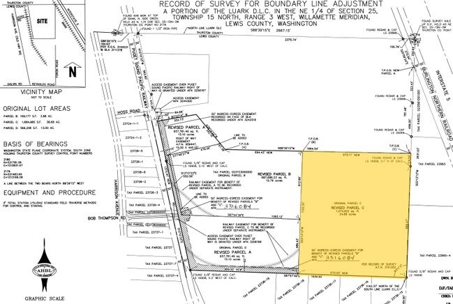
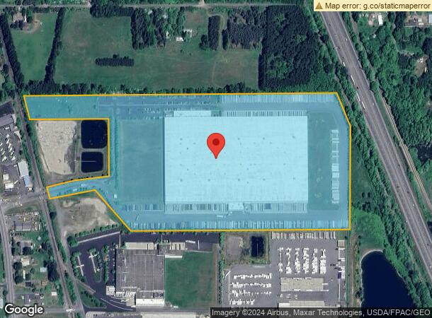
208 Hoss Rd
Centralia, WA
Centralia North 1 Comm C
750030-405-001
SECTION 25 TOWNSHIP 15N RANGE 03W PT NE4 PARCEL A COMMERCIAL CONDOMINIUM UNIT 1 & 69% COMMON AREA PER 3276209/3279011
Commercialnec
Lewis
2024
Washington
2025
16.50 AC
970300
Washington State Area
738,962 SF
Other Market Areas
DEMOGRAPHICS near 208 Hoss Rd
1 Mile
3 Mile
5 Mile
2024 Total Population
715
13,621
35,198
2029 Population
785
15,115
38,919
Pop Growth 2024-2029
+ 9.79%
+ 10.97%
+ 10.57%
Average Age
43
40
40
2024 Total Households
296
5,199
13,274
HH Growth 2024-2029
+ 10.14%
+ 11.16%
+ 10.77%
Median Household Inc
$48,974
$56,405
$61,849
Avg Household Size
2.40
2.50
2.60
2024 Avg HH Vehicles
2.00
2.00
2.00
Median Home Value
$308,333
$300,223
$319,653
Median Year Built
1984
1984
1982
Nearby Places
Map Layers
Map Styles
 Street
 Aerial
- Restaurants
- Banks
- Shops
- Fitness
- Groceries
PUBLIC TRANSPORTATION
COMMUTER RAIL
Centralia Amtrak Station (Amtrak Cascades - Amtrak, Coast Starlight - Amtrak)
DRIVE
WALK
Distance
Centralia Amtrak Station (Amtrak Cascades - Amtrak, Coast Starlight - Amtrak)
12 min
4.8 mi
Freight Ports
Port of Grays Harbor, WA
DRIVE
WALK
Distance
Port of Grays Harbor, WA
79 min
51.0 mi
Nearby Properties
Address
Land Use
TOTAL SIZE
Lot Size
Zoning
Address
Land Use
TOTAL SIZE
Lot Size
Zoning
1,038,447 SF
77 AC
PMP
Address
Land Use
TOTAL SIZE
Lot Size
Zoning
441,608 SF
Address
Land Use
TOTAL SIZE
Lot Size
Zoning
32,914 SF
3.38 AC
PMP
Address
Land Use
TOTAL SIZE
Lot Size
Zoning
229,011 SF
209.52 AC
PID
Address
Land Use
TOTAL SIZE
Lot Size
Zoning
155,458 SF
15.79 AC
PMP
Address
Land Use
TOTAL SIZE
Lot Size
Zoning
1,427 SF
15.22 AC
Address
Land Use
TOTAL SIZE
Lot Size
Zoning
129,242 SF
11.91 AC
M1
Address
Land Use
TOTAL SIZE
Lot Size
Zoning
1,792 SF
38.78 AC
OSPF
Address
Land Use
TOTAL SIZE
Lot Size
Zoning
14,264 SF
6.60 AC
R20
Address
Land Use
TOTAL SIZE
Lot Size
Zoning
196,060 SF
24.68 AC
PMP
Address
Land Use
TOTAL SIZE
Lot Size
Zoning
7,200 SF
4 AC
OSPF
Address
Land Use
TOTAL SIZE
Lot Size
Zoning
28,522 SF
2 AC
M2
Address
Land Use
TOTAL SIZE
Lot Size
Zoning
29,204 SF
3.91 AC
R20
Address
Land Use
TOTAL SIZE
Lot Size
Zoning
75,993 SF
18.76 AC
PMP
Address
Land Use
TOTAL SIZE
Lot Size
Zoning
Address
Land Use
TOTAL SIZE
Lot Size
Zoning
104,872 SF
Address
Land Use
TOTAL SIZE
Lot Size
Zoning
3,536 SF
1.73 AC
R20
Address
Land Use
TOTAL SIZE
Lot Size
Zoning
1,512 SF
8.64 AC
OSPF
Address
Land Use
TOTAL SIZE
Lot Size
Zoning
21,672 SF
2.08 AC
R20
Address
Land Use
TOTAL SIZE
Lot Size
Zoning
34,408 SF
3.58 AC
C1
Address
Land Use
TOTAL SIZE
Lot Size
Zoning
940 SF
1.50 AC
Address
Land Use
TOTAL SIZE
Lot Size
Zoning
1,161 SF
2.11 AC
R15
Address
Land Use
TOTAL SIZE
Lot Size
Zoning
2,088 SF
1.48 AC
R15
Address
Land Use
TOTAL SIZE
Lot Size
Zoning
4,104 SF
79.55 AC
M2
Address
Land Use
TOTAL SIZE
Lot Size
Zoning
15,947 SF
2.14 AC
C2
Address
Land Use
TOTAL SIZE
Lot Size
Zoning
34,579 SF
94.12 AC
OSPF
Address
Land Use
TOTAL SIZE
Lot Size
Zoning
7.13 AC
Address
Land Use
TOTAL SIZE
Lot Size
Zoning
46,154 SF
5.10 AC
C2
Address
Land Use
TOTAL SIZE
Lot Size
Zoning
35,000 SF
2.13 AC
C2
The World's #1 Commercial Real Estate Marketplace
Connect with us
© 2025 CoStar Group
The information above has been obtained from sources believed reliable. While we do not doubt its accuracy we have not verified it and make no guarantee, warranty or representation about it. It is your responsibility to independently confirm its accuracy and completeness. Any projections, opinions, assumptions, or estimates used are for example only and do not represent the current or future performance of the property. The value of this transaction to you depends on tax and other factors which should be evaluated by your tax, financial, and legal advisors. You and your advisors should conduct a careful, independent investigation of the property to determine to your satisfaction the suitability of the property for your needs.