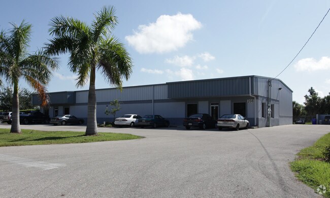
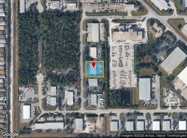
Property Record
208 Waldo Ave, Lehigh Acres, FL 33971

NEARBY LISTINGS FOR SALE OR LEASE
Property Detail
208 Waldo Ave
Cape Coral-Fort Myers, FL
Lehigh Estates
30-44-26-00-00001.0380
PARL LYING IN W 1/2 OF W 1/2 OF SW 1/4 AS DESC IN SEC 30 VACATED DESC OR 3244/1066 F/N/A/LEHIGH ESTATES UT 1 BLK 4 PB 15 PG 81 LTS 8 THRU 12 OR 4115 PG 4727
Warehouse
Lee
X
Florida
12071C0432F
8-12
2024
0.83 AC
2025
Lehigh
040121
Southwest Florida
7,520 SF
DEMOGRAPHICS near 208 Waldo Ave
1 Mile
3 Mile
5 Mile
2024 Total Population
5,256
45,161
104,323
2029 Population
6,127
53,421
124,239
Pop Growth 2024-2029
+ 16.57%
+ 18.29%
+ 19.09%
Average Age
34
41
41
2024 Total Households
1,595
16,465
38,639
HH Growth 2024-2029
+ 16.18%
+ 18.26%
+ 19.25%
Median Household Inc
$71,920
$71,972
$69,565
Avg Household Size
3.10
2.60
2.50
2024 Avg HH Vehicles
2.00
2.00
2.00
Median Home Value
$270,932
$295,090
$287,187
Median Year Built
2004
2005
2005
Nearby Places
Map Layers
Map Styles
 Street
 Aerial
- Restaurants
- Banks
- Shops
- Fitness
- Groceries
PUBLIC TRANSPORTATION
AIRPORT
Southwest Florida International
DRIVE
WALK
Distance
Southwest Florida International
17 min
8.1 mi
Punta Gorda
DRIVE
WALK
Distance
Punta Gorda
38 min
29.1 mi
Freight Ports
Port Manatee
DRIVE
WALK
Distance
Port Manatee
118 min
100.7 mi
Nearby Properties
Address
Land Use
TOTAL SIZE
Lot Size
Zoning
Address
Land Use
TOTAL SIZE
Lot Size
Zoning
362,391 SF
12.80 AC
SDA
Address
Land Use
TOTAL SIZE
Lot Size
Zoning
24.69 AC
C-1
Address
Land Use
TOTAL SIZE
Lot Size
Zoning
432,890 SF
18.88 AC
SDA
Address
Land Use
TOTAL SIZE
Lot Size
Zoning
519,706 SF
95.18 AC
RS-1
Address
Land Use
TOTAL SIZE
Lot Size
Zoning
111.70 AC
C1
Address
Land Use
TOTAL SIZE
Lot Size
Zoning
324,346 SF
20 AC
C1
Address
Land Use
TOTAL SIZE
Lot Size
Zoning
9.07 AC
SDA
Address
Land Use
TOTAL SIZE
Lot Size
Zoning
17.50 AC
C1
Address
Land Use
TOTAL SIZE
Lot Size
Zoning
260,320 SF
8.81 AC
SDA
Address
Land Use
TOTAL SIZE
Lot Size
Zoning
333,614 SF
294.30 AC
AG-2
Address
Land Use
TOTAL SIZE
Lot Size
Zoning
6.99 AC
C-1
Address
Land Use
TOTAL SIZE
Lot Size
Zoning
6.38 AC
SDA
Address
Land Use
TOTAL SIZE
Lot Size
Zoning
67.46 AC
C1
Address
Land Use
TOTAL SIZE
Lot Size
Zoning
154,653 SF
11.77 AC
SDA
Address
Land Use
TOTAL SIZE
Lot Size
Zoning
230,967 SF
8.31 AC
SDA
Address
Land Use
TOTAL SIZE
Lot Size
Zoning
135,503 SF
15.29 AC
AG-2
Address
Land Use
TOTAL SIZE
Lot Size
Zoning
68.11 AC
PUD
Address
Land Use
TOTAL SIZE
Lot Size
Zoning
123,378 SF
13.59 AC
SDA
Address
Land Use
TOTAL SIZE
Lot Size
Zoning
127,637 SF
6.50 AC
SDA
Address
Land Use
TOTAL SIZE
Lot Size
Zoning
75,477 SF
13.12 AC
SDA
Address
Land Use
TOTAL SIZE
Lot Size
Zoning
72,819 SF
7.97 AC
SDA
Address
Land Use
TOTAL SIZE
Lot Size
Zoning
29.75 AC
CI
Address
Land Use
TOTAL SIZE
Lot Size
Zoning
85,812 SF
15.76 AC
PUD
Address
Land Use
TOTAL SIZE
Lot Size
Zoning
95,220 SF
3.23 AC
SDA
Address
Land Use
TOTAL SIZE
Lot Size
Zoning
103,801 SF
2.63 AC
SDA
Address
Land Use
TOTAL SIZE
Lot Size
Zoning
66,292 SF
2.78 AC
SDA
Address
Land Use
TOTAL SIZE
Lot Size
Zoning
2.10 AC
C1
Address
Land Use
TOTAL SIZE
Lot Size
Zoning
106,286 SF
16.57 AC
PUD
Address
Land Use
TOTAL SIZE
Lot Size
Zoning
2.11 AC
SDA
Address
Land Use
TOTAL SIZE
Lot Size
Zoning
73,722 SF
4.07 AC
CG
The World's #1 Commercial Real Estate Marketplace
Connect with us
© 2025 CoStar Group
The information above has been obtained from sources believed reliable. While we do not doubt its accuracy we have not verified it and make no guarantee, warranty or representation about it. It is your responsibility to independently confirm its accuracy and completeness. Any projections, opinions, assumptions, or estimates used are for example only and do not represent the current or future performance of the property. The value of this transaction to you depends on tax and other factors which should be evaluated by your tax, financial, and legal advisors. You and your advisors should conduct a careful, independent investigation of the property to determine to your satisfaction the suitability of the property for your needs.