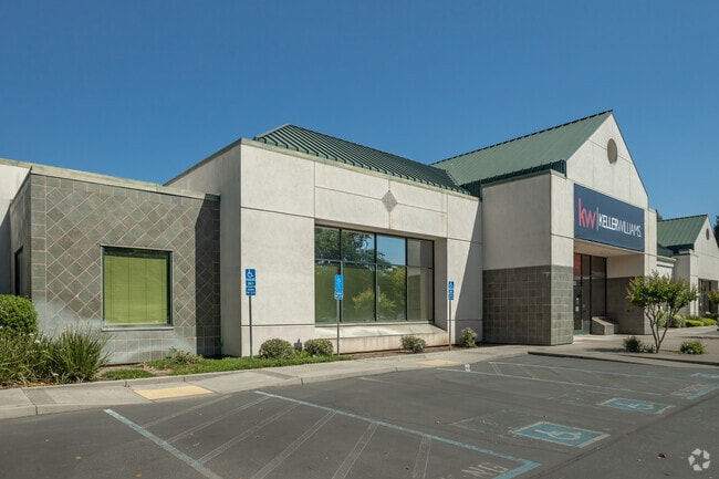
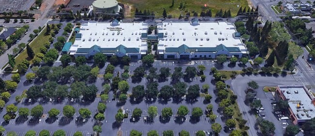
Property Record
2080 E 20Th St, Chico, CA 95928

Current Lease Availabilities
Property Detail
2080 E 20Th St
002-370-079-000
PCL 1 & PTN PCL 2 PM 147-70
Financialbuilding
BUTTE
OC
California
B and X Area of moderate flood hazard, usually the area between the limits of the 100-year and 500-year floods.
10.18 AC
2024
Redding/Chico
2025
Other Market Areas
000903
Chico, CA
99,180 SF
NEARBY LISTINGS FOR SALE OR LEASE
DEMOGRAPHICS near 2080 E 20Th St
1 mile
3 mile
5 mile
2025 Total Population
8,003
50,977
93,639
2030 Population
7,901
50,103
91,724
Pop Growth 2025-2030
(1.27%)
(1.71%)
(2.05%)
Average Age
37
37
37
2025 Total Households
3,330
20,975
38,471
HH Growth 2025-2030
(1.17%)
(1.89%)
(2.23%)
Median Household Inc
$68,633
$66,067
$66,280
Avg Household Size
2.30
2.30
2.30
2025 Avg HH Vehicles
2.00
2.00
2.00
Median Home Value
$463,450
$477,681
$468,060
Median Year Built
1991
1979
1981
Nearby Places
Map Layers
Map Styles
 Street
 Aerial
Transit
 Traffic
 Biking
Places
Listings with unknown addresses are not visible on the map
- Restaurants
- Banks
- Shops
- Fitness
- Groceries
PUBLIC TRANSPORTATION
COMMUTER RAIL
Chico Amtrak (Coast Starlight - Amtrak)
Drive
Walk
Distance
Chico Amtrak (Coast Starlight - Amtrak)
7 min
3.5 mi
Freight Ports
Port of Stockton
Drive
Walk
Distance
Port of Stockton
159 min
130.8 mi
Nearby Properties
Address
Land Use
TOTAL SIZE
Lot Size
Zoning
Address
Land Use
TOTAL SIZE
Lot Size
Zoning
150,000 SF
2.31 AC
Address
Land Use
TOTAL SIZE
Lot Size
Zoning
135,668 SF
3.43 AC
PQ
Address
Land Use
TOTAL SIZE
Lot Size
Zoning
102,010 SF
12.55 AC
Address
Land Use
TOTAL SIZE
Lot Size
Zoning
58,013 SF
7.08 AC
TND
Address
Land Use
TOTAL SIZE
Lot Size
Zoning
13,186 SF
4.97 AC
R2
Address
Land Use
TOTAL SIZE
Lot Size
Zoning
32,880 SF
25.36 AC
Address
Land Use
TOTAL SIZE
Lot Size
Zoning
20,643 SF
3.32 AC
TND
Address
Land Use
TOTAL SIZE
Lot Size
Zoning
185,744 SF
10.15 AC
Address
Land Use
TOTAL SIZE
Lot Size
Zoning
84,280 SF
1.60 AC
R4
Address
Land Use
TOTAL SIZE
Lot Size
Zoning
21,216 SF
9.60 AC
CC
Address
Land Use
TOTAL SIZE
Lot Size
Zoning
104,992 SF
5.64 AC
CN
Address
Land Use
TOTAL SIZE
Lot Size
Zoning
133,120 SF
5.37 AC
R3
Address
Land Use
TOTAL SIZE
Lot Size
Zoning
141,333 SF
7.08 AC
Address
Land Use
TOTAL SIZE
Lot Size
Zoning
56,480 SF
10.28 AC
PQ
Address
Land Use
TOTAL SIZE
Lot Size
Zoning
158,426 SF
16.19 AC
M1
Address
Land Use
TOTAL SIZE
Lot Size
Zoning
72,372 SF
1.90 AC
R3
Address
Land Use
TOTAL SIZE
Lot Size
Zoning
13,459 SF
3.61 AC
Address
Land Use
TOTAL SIZE
Lot Size
Zoning
160,214 SF
13.50 AC
Address
Land Use
TOTAL SIZE
Lot Size
Zoning
175,392 SF
14.83 AC
Address
Land Use
TOTAL SIZE
Lot Size
Zoning
31,291 SF
6.10 AC
CR
Address
Land Use
TOTAL SIZE
Lot Size
Zoning
44,492 SF
2.05 AC
R3
Address
Land Use
TOTAL SIZE
Lot Size
Zoning
18,809 SF
13.55 AC
Address
Land Use
TOTAL SIZE
Lot Size
Zoning
3.30 AC
CR
Address
Land Use
TOTAL SIZE
Lot Size
Zoning
51,698 SF
3.88 AC
C2
Address
Land Use
TOTAL SIZE
Lot Size
Zoning
24.26 AC
Address
Land Use
TOTAL SIZE
Lot Size
Zoning
90,400 SF
7.50 AC
Address
Land Use
TOTAL SIZE
Lot Size
Zoning
51,805 SF
2.50 AC
CN
Address
Land Use
TOTAL SIZE
Lot Size
Zoning
105,700 SF
10.03 AC
Address
Land Use
TOTAL SIZE
Lot Size
Zoning
22,032 SF
8.66 AC
The World's #1 Commercial Real Estate Marketplace
Connect with us
© 2026 CoStar Group
The information above has been obtained from sources believed reliable. While we do not doubt its accuracy we have not verified it and make no guarantee, warranty or representation about it. It is your responsibility to independently confirm its accuracy and completeness. Any projections, opinions, assumptions, or estimates used are for example only and do not represent the current or future performance of the property. The value of this transaction to you depends on tax and other factors which should be evaluated by your tax, financial, and legal advisors. You and your advisors should conduct a careful, independent investigation of the property to determine to your satisfaction the suitability of the property for your needs.