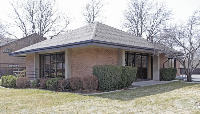
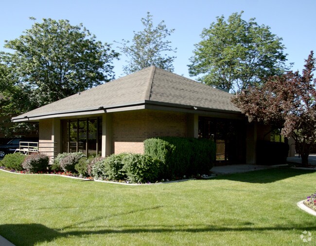
Property Record
2080 E Murray Holladay Rd, Salt Lake City, UT 84117

NEARBY LISTINGS FOR SALE OR LEASE
Property Detail
2080 E Murray Holladay Rd
22-10-106-006-0000
BEG 1880.09 FT N & 1747.97 FT W FT FR CEN OF SEC 10, T 2S, R1E, S L M; S 65^07 W 185.934 FT; N 25^ W 86.53 FT; N 65^57E 78.87 FT; N 14^30 W 54.897 FT; NELY ALG A CURVE TO L 46.008 FT; SELY ALG A CURVE TO R 15.309 FT; S 44^ E 127.117FT TO BEG. 0.40 AC
Medicalbuilding
Salt Lake
X
Utah
49035C0312G
0.40 AC
2024
Central Valley East
2025
Salt Lake City
110800
Salt Lake City-Murray, UT
2,874 SF
DEMOGRAPHICS near 2080 E Murray Holladay Rd
1 Mile
3 Mile
5 Mile
2024 Total Population
13,955
118,869
281,009
2029 Population
14,071
119,670
283,715
Pop Growth 2024-2029
+ 0.83%
+ 0.67%
+ 0.96%
Average Age
41
40
39
2024 Total Households
5,360
46,764
111,129
HH Growth 2024-2029
+ 0.76%
+ 0.58%
+ 0.95%
Median Household Inc
$84,724
$83,143
$78,405
Avg Household Size
2.50
2.50
2.40
2024 Avg HH Vehicles
2.00
2.00
2.00
Median Home Value
$724,066
$598,956
$521,678
Median Year Built
1969
1972
1974
Nearby Places
Map Layers
Map Styles
 Street
 Aerial
- Restaurants
- Banks
- Shops
- Fitness
- Groceries
PUBLIC TRANSPORTATION
AIRPORT
Salt Lake City International
DRIVE
WALK
Distance
Salt Lake City International
24 min
15.5 mi
Provo Municipal
DRIVE
WALK
Distance
Provo Municipal
54 min
43.2 mi
Nearby Properties
Address
Land Use
TOTAL SIZE
Lot Size
Zoning
Address
Land Use
TOTAL SIZE
Lot Size
Zoning
207,140 SF
23.06 AC
P
Address
Land Use
TOTAL SIZE
Lot Size
Zoning
257,003 SF
25.87 AC
1108
Address
Land Use
TOTAL SIZE
Lot Size
Zoning
691,463 SF
17.80 AC
RM
Address
Land Use
TOTAL SIZE
Lot Size
Zoning
524,108 SF
34.46 AC
RM
Address
Land Use
TOTAL SIZE
Lot Size
Zoning
302,944 SF
5.47 AC
Address
Land Use
TOTAL SIZE
Lot Size
Zoning
369,717 SF
2.50 AC
RO
Address
Land Use
TOTAL SIZE
Lot Size
Zoning
412,006 SF
1.70 AC
C3
Address
Land Use
TOTAL SIZE
Lot Size
Zoning
225,849 SF
16.36 AC
RM-ZC
Address
Land Use
TOTAL SIZE
Lot Size
Zoning
21,057 SF
17.96 AC
RM20
Address
Land Use
TOTAL SIZE
Lot Size
Zoning
125,518 SF
11.03 AC
RMZC
Address
Land Use
TOTAL SIZE
Lot Size
Zoning
371,607 SF
10.77 AC
A-1
Address
Land Use
TOTAL SIZE
Lot Size
Zoning
33,164 SF
6.88 AC
RM
Address
Land Use
TOTAL SIZE
Lot Size
Zoning
37,563 SF
15.34 AC
RM20
Address
Land Use
TOTAL SIZE
Lot Size
Zoning
28,078 SF
15.33 AC
RM-10
Address
Land Use
TOTAL SIZE
Lot Size
Zoning
241,418 SF
8.84 AC
ORD
Address
Land Use
TOTAL SIZE
Lot Size
Zoning
299,673 SF
2.16 AC
C3
Address
Land Use
TOTAL SIZE
Lot Size
Zoning
83,204 SF
12.87 AC
RM
Address
Land Use
TOTAL SIZE
Lot Size
Zoning
126,900 SF
0.38 AC
1108
Address
Land Use
TOTAL SIZE
Lot Size
Zoning
99,702 SF
12.73 AC
R-M
Address
Land Use
TOTAL SIZE
Lot Size
Zoning
84,246 SF
6.51 AC
RM
Address
Land Use
TOTAL SIZE
Lot Size
Zoning
317,495 SF
2.75 AC
O-R-D
Address
Land Use
TOTAL SIZE
Lot Size
Zoning
77,051 SF
8.34 AC
RM/ZC
Address
Land Use
TOTAL SIZE
Lot Size
Zoning
63,922 SF
7.96 AC
RM
Address
Land Use
TOTAL SIZE
Lot Size
Zoning
63,922 SF
3 AC
RM
Address
Land Use
TOTAL SIZE
Lot Size
Zoning
433,385 SF
3.64 AC
R/M-U
Address
Land Use
TOTAL SIZE
Lot Size
Zoning
132,942 SF
18 AC
1108
Address
Land Use
TOTAL SIZE
Lot Size
Zoning
150,570 SF
12.76 AC
ORD
Address
Land Use
TOTAL SIZE
Lot Size
Zoning
71,504 SF
7.11 AC
R-1-10
Address
Land Use
TOTAL SIZE
Lot Size
Zoning
222,312 SF
1.39 AC
MCCD
Address
Land Use
TOTAL SIZE
Lot Size
Zoning
97,657 SF
6.66 AC
RM
The World's #1 Commercial Real Estate Marketplace
Connect with us
© 2026 CoStar Group
The information above has been obtained from sources believed reliable. While we do not doubt its accuracy we have not verified it and make no guarantee, warranty or representation about it. It is your responsibility to independently confirm its accuracy and completeness. Any projections, opinions, assumptions, or estimates used are for example only and do not represent the current or future performance of the property. The value of this transaction to you depends on tax and other factors which should be evaluated by your tax, financial, and legal advisors. You and your advisors should conduct a careful, independent investigation of the property to determine to your satisfaction the suitability of the property for your needs.