Property Record
2080 E Williams St, Apex, NC 27539
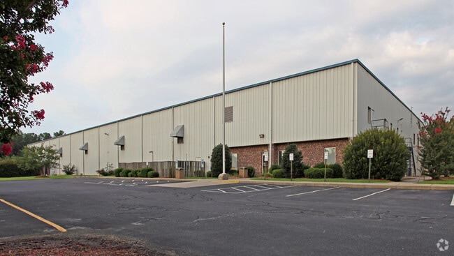

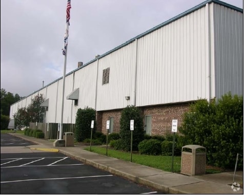

Property Detail
2080 E Williams St
0740.02-86-9031-000
HOPE COMMUNITY CHURCH SITE BM2016-01690
Religious
Wake
TF-CZ
North Carolina
B and X Area of moderate flood hazard, usually the area between the limits of the 100-year and 500-year floods.
12.66 AC
0
Southwest Wake County
2025
Raleigh/Durham
053432
Raleigh-Cary, NC
99,326 SF
NEARBY LISTINGS FOR SALE OR LEASE
DEMOGRAPHICS near 2080 E Williams St
1 mile
3 mile
5 mile
2025 Total Population
4,733
50,497
137,621
2030 Population
5,031
54,434
148,924
Pop Growth 2025-2030
+ 6.30%
+ 7.80%
+ 8.21%
Average Age
35
38
39
2025 Total Households
1,718
17,872
48,348
HH Growth 2025-2030
+ 6.69%
+ 8.26%
+ 8.60%
Median Household Inc
$100,771
$122,842
$137,702
Avg Household Size
2.80
2.80
2.80
2025 Avg HH Vehicles
2.00
2.00
2.00
Median Home Value
$448,823
$573,872
$612,695
Median Year Built
2002
2004
2004
Nearby Places
Map Layers
Map Styles
 Street
 Aerial
Transit
 Traffic
 Biking
Places
Listings with unknown addresses are not visible on the map
- Restaurants
- Banks
- Shops
- Fitness
- Groceries
PUBLIC TRANSPORTATION
COMMUTER RAIL
Cary Station (Piedmont - North Carolina by Train (NC Train))
Drive
Walk
Distance
Cary Station (Piedmont - North Carolina by Train (NC Train))
17 min
9.5 mi
AIRPORT
Raleigh-Durham International
Drive
Walk
Distance
Raleigh-Durham International
28 min
20.5 mi
Nearby Properties
Address
Land Use
TOTAL SIZE
Lot Size
Zoning
Address
Land Use
TOTAL SIZE
Lot Size
Zoning
402,468 SF
37.03 AC
HD MF
Address
Land Use
TOTAL SIZE
Lot Size
Zoning
362,567 SF
17.97 AC
NMX
Address
Land Use
TOTAL SIZE
Lot Size
Zoning
364,727 SF
27.65 AC
RMF-C
Address
Land Use
TOTAL SIZE
Lot Size
Zoning
301,882 SF
19.44 AC
MXR
Address
Land Use
TOTAL SIZE
Lot Size
Zoning
338,234 SF
18.77 AC
PUD-C
Address
Land Use
TOTAL SIZE
Lot Size
Zoning
260,809 SF
18.80 AC
HD MF
Address
Land Use
TOTAL SIZE
Lot Size
Zoning
242,251 SF
35.55 AC
SR
Address
Land Use
TOTAL SIZE
Lot Size
Zoning
208,323 SF
36.14 AC
CB
Address
Land Use
TOTAL SIZE
Lot Size
Zoning
230,176 SF
16.83 AC
MXR
Address
Land Use
TOTAL SIZE
Lot Size
Zoning
210,686 SF
14.57 AC
PUD-C
Address
Land Use
TOTAL SIZE
Lot Size
Zoning
361,582 SF
45.01 AC
LI
Address
Land Use
TOTAL SIZE
Lot Size
Zoning
221,860 SF
40.32 AC
PUD
Address
Land Use
TOTAL SIZE
Lot Size
Zoning
302,498 SF
25.99 AC
LI-CZ
Address
Land Use
TOTAL SIZE
Lot Size
Zoning
160,410 SF
14.11 AC
PUD-C
Address
Land Use
TOTAL SIZE
Lot Size
Zoning
234,000 SF
21.53 AC
LI-CZ
Address
Land Use
TOTAL SIZE
Lot Size
Zoning
161,910 SF
22.83 AC
HD MF
Address
Land Use
TOTAL SIZE
Lot Size
Zoning
138,083 SF
16.18 AC
LI-CU
Address
Land Use
TOTAL SIZE
Lot Size
Zoning
99,330 SF
11.05 AC
OIP
Address
Land Use
TOTAL SIZE
Lot Size
Zoning
161,082 SF
11.62 AC
MD
Address
Land Use
TOTAL SIZE
Lot Size
Zoning
144,356 SF
31.35 AC
HD MF
Address
Land Use
TOTAL SIZE
Lot Size
Zoning
95,819 SF
22.63 AC
NR
Address
Land Use
TOTAL SIZE
Lot Size
Zoning
146,215 SF
22.83 AC
LI
Address
Land Use
TOTAL SIZE
Lot Size
Zoning
503,896 SF
80.17 AC
LI
Address
Land Use
TOTAL SIZE
Lot Size
Zoning
95,937 SF
11.44 AC
LI
Address
Land Use
TOTAL SIZE
Lot Size
Zoning
125,702 SF
1.35 AC
GCP
Address
Land Use
TOTAL SIZE
Lot Size
Zoning
86,830 SF
6.59 AC
LI
Address
Land Use
TOTAL SIZE
Lot Size
Zoning
145,707 SF
15.40 AC
PUD
Address
Land Use
TOTAL SIZE
Lot Size
Zoning
59,764 SF
8.36 AC
MXR
Address
Land Use
TOTAL SIZE
Lot Size
Zoning
85,705 SF
11.01 AC
GCP
The World's #1 Commercial Real Estate Marketplace
Connect with us
© 2026 CoStar Group
The information above has been obtained from sources believed reliable. While we do not doubt its accuracy we have not verified it and make no guarantee, warranty or representation about it. It is your responsibility to independently confirm its accuracy and completeness. Any projections, opinions, assumptions, or estimates used are for example only and do not represent the current or future performance of the property. The value of this transaction to you depends on tax and other factors which should be evaluated by your tax, financial, and legal advisors. You and your advisors should conduct a careful, independent investigation of the property to determine to your satisfaction the suitability of the property for your needs.