Property Record
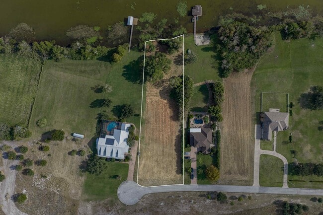
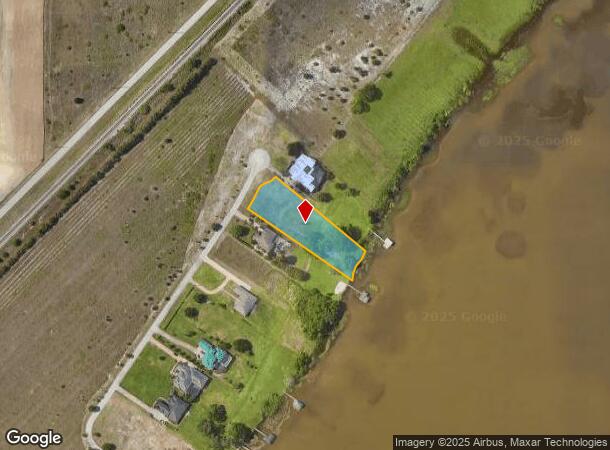
2080 Kennwood Grove Ln, Auburndale, FL 33823
This Property Is For Sale
NEARBY LISTINGS FOR SALE OR LEASE
Property Detail
2080 Kennwood Grove Ln
Lakeland-Winter Haven, FL
Kennwood On The Lake
25-28-01-307623-000090
KENNWOOD ON THE LAKE PB 121 PGS 15 & 16 LOT 9
Vacantlandnec
Polk
AE
Florida
12105C0335G
9
2024
1.24 AC
2025
Polk County
013002
Tampa/St Petersburg
DEMOGRAPHICS near 2080 Kennwood Grove Ln
1 Mile
3 Mile
5 Mile
2024 Total Population
5,652
39,433
89,604
2029 Population
6,510
45,396
103,027
Pop Growth 2024-2029
+ 15.18%
+ 15.12%
+ 14.98%
Average Age
40
41
41
2024 Total Households
2,108
15,033
34,860
HH Growth 2024-2029
+ 15.46%
+ 15.33%
+ 15.23%
Median Household Inc
$64,285
$65,916
$62,398
Avg Household Size
2.70
2.60
2.50
2024 Avg HH Vehicles
2.00
2.00
2.00
Median Home Value
$314,774
$303,262
$273,904
Median Year Built
1990
1987
1985
Nearby Places
- Restaurants
- Banks
- Shops
- Fitness
- Groceries
PUBLIC TRANSPORTATION
COMMUTER RAIL
Winter Haven (Silver Meteor - Amtrak, Silver Star - Amtrak)
DRIVE
WALK
Distance
Winter Haven (Silver Meteor - Amtrak, Silver Star - Amtrak)
18 min
7.9 mi
Freight Ports
Port of Tampa Bay
DRIVE
WALK
Distance
Port of Tampa Bay
69 min
46.4 mi
Nearby Properties
Address
Land Use
TOTAL SIZE
Lot Size
Zoning
Address
Land Use
TOTAL SIZE
Lot Size
Zoning
942,646 SF
91.30 AC
R3
Address
Land Use
TOTAL SIZE
Lot Size
Zoning
238,721 SF
11.66 AC
GI
Address
Land Use
TOTAL SIZE
Lot Size
Zoning
282,400 SF
19.59 AC
XX
Address
Land Use
TOTAL SIZE
Lot Size
Zoning
136,724 SF
4.62 AC
GI
Address
Land Use
TOTAL SIZE
Lot Size
Zoning
108,360 SF
4.23 AC
GI
Address
Land Use
TOTAL SIZE
Lot Size
Zoning
148,390 SF
10.42 AC
R1
Address
Land Use
TOTAL SIZE
Lot Size
Zoning
178,899 SF
10.09 AC
GI
Address
Land Use
TOTAL SIZE
Lot Size
Zoning
291,428 SF
59.34 AC
Address
Land Use
TOTAL SIZE
Lot Size
Zoning
122,364 SF
34.98 AC
Address
Land Use
TOTAL SIZE
Lot Size
Zoning
123,540 SF
5.89 AC
Address
Land Use
TOTAL SIZE
Lot Size
Zoning
129,567 SF
11.72 AC
C3
Address
Land Use
TOTAL SIZE
Lot Size
Zoning
76,664 SF
18.64 AC
RP
Address
Land Use
TOTAL SIZE
Lot Size
Zoning
191,975 SF
14.28 AC
HI
Address
Land Use
TOTAL SIZE
Lot Size
Zoning
160,755 SF
9.94 AC
Address
Land Use
TOTAL SIZE
Lot Size
Zoning
320,765 SF
14.93 AC
GI
Address
Land Use
TOTAL SIZE
Lot Size
Zoning
42,400 SF
121.06 AC
RC
Address
Land Use
TOTAL SIZE
Lot Size
Zoning
106,376 SF
18.36 AC
Address
Land Use
TOTAL SIZE
Lot Size
Zoning
42,668 SF
9.44 AC
R2
Address
Land Use
TOTAL SIZE
Lot Size
Zoning
44,662 SF
5.76 AC
Address
Land Use
TOTAL SIZE
Lot Size
Zoning
169,925 SF
11.88 AC
C3
Address
Land Use
TOTAL SIZE
Lot Size
Zoning
309,124 SF
31.33 AC
XX
Address
Land Use
TOTAL SIZE
Lot Size
Zoning
28,304 SF
10.28 AC
RE1
Address
Land Use
TOTAL SIZE
Lot Size
Zoning
122,260 SF
4.77 AC
Address
Land Use
TOTAL SIZE
Lot Size
Zoning
90,077 SF
12.41 AC
Address
Land Use
TOTAL SIZE
Lot Size
Zoning
199,355 SF
15.71 AC
C4
Address
Land Use
TOTAL SIZE
Lot Size
Zoning
69,835 SF
7.06 AC
CH
Address
Land Use
TOTAL SIZE
Lot Size
Zoning
84,312 SF
13.64 AC
Address
Land Use
TOTAL SIZE
Lot Size
Zoning
80,100 SF
4.68 AC
GI
Address
Land Use
TOTAL SIZE
Lot Size
Zoning
30,638 SF
4.22 AC
R3
Address
Land Use
TOTAL SIZE
Lot Size
Zoning
50,210 SF
4.67 AC
XX
The World's #1 Commercial Real Estate Marketplace
Connect with us
© 2025 CoStar Group
The information above has been obtained from sources believed reliable. While we do not doubt its accuracy we have not verified it and make no guarantee, warranty or representation about it. It is your responsibility to independently confirm its accuracy and completeness. Any projections, opinions, assumptions, or estimates used are for example only and do not represent the current or future performance of the property. The value of this transaction to you depends on tax and other factors which should be evaluated by your tax, financial, and legal advisors. You and your advisors should conduct a careful, independent investigation of the property to determine to your satisfaction the suitability of the property for your needs.